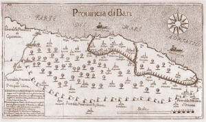
A detail of the map shown above, showing soundings in fathoms, “conspicuous objects circled in red,” and the five zones where six Canadian regiments were first ashore on June 6, 1944.
(Map: Detail of Juno area, Beach Chartlet. n.s., 1944, issued for Fleet Purposes by the Hydrographic Dept. of the Admiralty, 18th Feb. 1944 under the Superintendence of Vice-Admiral Sir John Edgell K.B.E., C.B., F.R.S., Hydrographer, 1944, Ian William Workman fonds, Library and Archives Canada, e011297133. Photo: Canadian soldiers, including Capt. M.A. Cardinal, from Régiment de la Chaudière with residents of Bernières-sur-Mer on June 6, 1944, Library and Archives Canada/Department of National Defence fonds/e010750632)
Like most of the Canadians fighting that day, Hester and his regiment encountered stiff resistance from German forces whose defences had been largely unaffected by the pre-landing bombardment. Still, by the end of the first day, the Canadians had secured the beach and cleared German troops from Saint-Aubin-sur-Mer, Bernières-sur-Mer and Courseulles-sur-Mer, and advanced farther inland than any other troops. Their success came at a cost, though, with 1,074 casualties, 359 of whom were killed. The Queen’s Own Rifles suffered the greatest loss of any Canadian unit on D-Day with 61 men killed. Hester himself was one of only three survivors from the regiment’s 10-man B Company.
The Juno Beach landings were one of the first steps in the long march toward the end of the Second World War. But for Canada, they were also an opportunity to distinguish itself, as military historian Mark Zuehlke writes in Juno Beach: Canada’s D-Day Victory: June 6, 1944, “Five Allied divisions landed that day — two American, two British, one Canadian. A David hit the beach alongside two Goliaths and did as well or better than the giants.”
*with files from Erika Reinhardt, archivist, Library and Archives Canada