Science & Tech
Six video games starring nature as the main character
How nature is levelling up in video games, from playing as a raccoon to navigating ecological grief
- 2132 words
- 9 minutes
This article is over 5 years old and may contain outdated information.
Mapping
Maps have long played a critical role in video games, whether as the main user interface, a reference guide, or both. As games become more sophisticated, so too does the cartography that underpins them.


“I wisely started with a map, and made the story fit.” —J.R.R. Tolkien
Guide Kassandra steps off a reconstructed trireme warship onto a wharf at the Port of Piraeus in Athens, Greece. The wooden vessel with bronze ram at the bow is powered by 170 oarsmen. Such ships were commonplace in the fourth to seventh centuries BC at the port, which has served Athens since ancient times.
Kassandra, decked out as a fifth-century mercenary, doesn’t break character to reveal her last name. She walks along a series of straight, cobblestone streets, passing wooden carts filled with bundled sacks, a blacksmith tending his anvil and ladies making rope amidst the sounds of lapping waves, the distant ringing of buoy bells and gulls squawking. As she reaches the city’s marble district, artisans re-enact shaping slabs of white marble into statues of celebrated warriors. “They truly are masters of their craft,” says Kassandra.
“Thank you, Kassandra,” quips Benjamin Hall, as a crowd watching Kassandra’s tour on a big screen behind him in a meeting room at the Wyndham Grand Athens hotel breaks into laughter. Like Jim Carrey’s Truman Burbank in the 1998 film The Truman Show, Kassandra has no clue she’s the main character in a simulated reality. Today Hall, the Canadian-based world director of the video game Kassandra stars in, Assassin’s Creed Odyssey, is playing puppeteer with an Xbox One controller.
Watch: A tour of Athens from Assassin’s Creed Odyssey
“The Piraeus was built using the Hippodamian style of urban design, the grid layout that’s very common today in North America,” says Hall. He’s the mastermind behind this historical fiction game’s recreation of ancient Greece circa 431 BC during the Peloponnesian War, and is showcasing the extraordinary efforts his Ubisoft Quebec team went to in designing the world, its cities, its architectural styles and its map — which at a glance appears identical to a real chart of Greece — for a group of journalists.
“We tried to accurately depict many of the different cities, villages and sanctuaries of the world,” says Hall, “but in a way that makes it interesting and fun and easy to learn to play.” To do so, he and his team create sets of basic maps for such areas and then drop them into their virtual world.
Maps have long played a critical role in video games, whether serving as the primary user interface, a player reference tool or both. This virtual cartographic world (and its remarkable Canadian connections), however, remains widely unheralded, even as mapping has become increasingly important to many games.

“Sometimes the maps represent the actual locations, sometimes made up places, but they always contain a graphical language specifically designed to fit the overall tone of the game,” wrote Spanish architects Enrique Parra and Manuel Saga in “Cartography in the Metaverse: The Power of Mapping in Video Games,” a blog published in March 2016.
“Someone who has experience in video games also has experience in how their spaces are represented,” the article concludes. “This brings cartographic and architectural language closer to the general public than ever before.”
Be they old-school two-dimensional environments (think Pong) or modern 3D worlds, spatial awareness in a virtual realm is a necessity for playing most video games. And as games advanced from their infancy in the 1970s, so too did the need for players to be able to understand their simulated environments.
In the earliest days, many gamers filled the void of in-game wayfinding by creating their own maps. And even as designers began to include basic maps in games, players continued to create their own charts. Some 40,000 such cartographic creations for more than 2,000 games are collected on VGMaps.com: The Video Game Atlas.
The site’s Edmonton-based founder, Jonathan Leung, 39, points to user creations such as those for Super Metroid and Castlevania: Symphony of the Night as particularly impressive, noting they’re more useful than in-game maps. Why? They convey in great detail the entirety of the small segments of two-dimensional space players see in a style similar to that of a mall directory map.

Most experts acknowledge the charts in the titles above among the industry’s early mapping milestones. Other cartographic evolutions in gaming often occurred in conjunction with new genres, such as the early role-playing games, or RPGs, of the 1990s.
“The original Pirates! [designed by Sid Meier, a Canadian] was very interesting because it came with a physical map that you had to use to take in-game measurements to actually understand where you were,” says Konstantinos Dimopoulos, 40, a self-described game urbanist and designer who’s just completed the manuscript for his book Virtual Cities: An Atlas & Exploration of Video Game Cities.
Based in Athens, Greece, Dimopoulos has a PhD in urban planning and geography and a master’s degree in urban and regional planning, making him uniquely qualified to share insights on mapping in video games. Dimopoulos’s list of games with revolutionary mapping approaches is akin to a reader’s list of classic literature: Final Fantasy, a 1987 RPG that was one of the first games to incorporate a map of its world similar to a real-world map; real-world location games such as 2000’s Deus Ex, the most recent sequels of which are produced by Eidos-Montréal and contain detailed site-plan maps of each level; and so-called sandbox games, where players can move nearly unfettered in large 3D worlds, such as the Grand Theft Auto series, which was first released in 1997 and sees players use GPS-like navigation to pinpoint their location and allow them to plan routes from point to point. He also highlights Meier’s strategy game Civilization, where players could customize their map of Earth as they built their own civilization.

Dimopoulos is particularly fond of Nintendo’s Zelda series, an early RPG famed among cartography-crazed gamers since the original debuted in 1986. “The latest Zelda: Breath of the Wild is interesting in the way it guides you around the map,” he says, noting that players can use the map for traditional navigation, including adding custom markers, but also to search out and explore intriguing geographic shapes. “It’s amazing how they’ve applied Lynch’s ideas on mental map creation in a non-urban environment,” says Dimopoulos in reference to noted American urban planner Kevin Lynch.
He’s similarly impressed with the aforementioned Assassin’s Creed series. “They’ve managed to more or less convincingly reconstruct everything from London to ancient Athens to Florence,” he says. “They’re really good at that.”
***
“We must come together now for the glory of Athens!” implores Greek statesman Perikles to a toga-clad crowd of about a dozen as guide Kassandra looks on.
“Glory for you!” barks a bystander hurling a tomato toward the stage. The glorious monuments of the Acropolis, the building of which were led by the real Perikles, loom in the background.
“The Parthenon is glorious, Perikles, but at what cost? How many triremes could we have built instead?” counters Kleon, an Athenian general at Perikles’ side.
The scene plays out atop the Pnyx, a rocky outcropping in central Athens that’s regarded as one of the earliest and most important sites in the creation of democracy. It’s just one of 50-plus real-life historic sites recreated in painstakingly accurate detail for Assassin’s Creed Odyssey.
The action RPG for home consoles, released by Ubisoft Quebec in October 2018, nabbed numerous best-of-2018 video game award nominations. (Its forerunners have combined to sell more than 125 million copies since the original debuted in 2007.) Beyond its renowned historical reconstructions, the franchise is also famed for its open-world environments. Odyssey has recreated an approximately 250-square-kilometre area of the Aegean Sea region.
“The maps are the most important thing,” says Hall about creating any video game, a comment echoed by most game designers. “One of the physical objectives,” he continues, “was to create a game world that had a recognizable footprint from a bird’s-eye perspective, from the unmistakable hand-shape of the Peloponnese to the cove of Salamis to the peninsula of Attica to the trident of Macedonia.”
Watch: Benjamin Hall, the world director for Assassin’s Creed Odyssey, explains how his Ubisoft Québec team used maps to build the game’s world
As real-world cartographers do, Hall and his team made informed cartographic generalizations to strike a balance between realistic replication and the map’s purpose, in this case to be “playable” in the game’s context. The result? By and large, the footprint of cities in Odyssey, while accurately reproduced, appear at a relatively larger scale than rural areas. It’s essentially a mash-up of two different scales at once.
“We needed to play about with scale,” says Hall. “We’ve got a world that’s much smaller than real life, but we want to still recreate a sense of depth and scale. And to make distances shorter so that players enjoy getting around.”
To create the basic topography, Hall’s team used digital elevation model mapping data from NASA. As the group — which includes terrain, landscape and architecture artists — refined its work, they relied on Google Maps, Google Earth, ordinance survey maps and historical maps. They also worked with a staff historian to define themes for various regions based on historic data for wealth, trade, population, leadership, allegiance and wildlife.

“From there, we drew paper maps of each region, with a rough notion of key landscape, cities, forts, sanctuaries and wildlife,” explains Hall. “This data was then worked on to create basic terrain layouts, which formed the very foundations of our world.”
The paper maps are then shared with the rest of the game’s developers, including writers so they can develop storylines based on them. The overall map then goes through a variety of drafts as it adapts to the competing needs of the design team before it’s finalized.
“We work very hard to try to make an authentic world, but it is a video game,” says Hall. “We have to make choices: technical, artistic and level-design choices. It’s not historical recreation. It’s an imagination of that.”
***
“Maps made for video games are not the same as maps in real life. But you will probably use the same skills reading them,” says Simon Dor, 33, a professor of video game studies at the Montreal campus of l’Université du Québec en Abitibi-Témiscamingue.
Dor, who wrote his PhD thesis on the history of strategies in real-time strategy video games and his master’s thesis on StarCraft, a military sci-fi franchise that debuted in 1998, says that video games are overlooked for the map-reading skills they impart.
“You have to know how to read a map in order to better understand a space. Some video games rely a lot on maps, and you have to be able to read them to play. That can be applied to real life.”
While players intuitively learn some cartographic basics from video games, Dor notes that the cartographic knowledge transfer from games to real-life technological applications is even greater. He points to drone manufacturers who are hiring user interface designers from the gaming world to build UI systems for drones. These are critical for understanding where the drone is and what it is seeing on a control screen. And real-world location games also reinforce real-world geography. “If you play a game that represents Europe throughout history, for example,” says Dor, “you will know most of the countries because of your experience in the game.”
Lynn Moorman, a professor in the department of earth and environmental sciences at Calgary’s Mount Royal University, concurs. She explored how people were interpreting geographical concepts from real-world digital maps in her PhD thesis and found that people “used the same navigation strategies exploring Google Earth as they do in video games.”
Moorman identified four specific areas of overlap between Google Earth and video games, including understanding content at different scales when the scale keeps moving, spatial orientation, top-down versus oblique perspectives and “dimensional transformation,” where a user reimagines a two-dimensional environment on a screen as a three-dimensional space.
Coincidentally (or perhaps not?), in March 2018, Google made its Maps interface available to game developers who want to use its real-world geo-graphy, geometry and 100 million 3D building and landmark footprints. Now game studios can import Google Maps data directly into a Google-based gaming software and tweak or add elements as desired.
The move followed the runaway success of the augmented reality mobile game Pokémon Go. The app, which spawned a craze of gamers of all ages roaming their local communities in packs in search of virtual Pokémon, or “pocket monsters,” after its release in July 2016, was the first game built on such technology. It combined Google Maps and virtual reality and has since been downloaded 800 million times. Now The Walking Dead: Our World (zombie chasing), Ghostbusters World (ghost stalking) and Jurassic World Alive (dino hunting) have joined Go as some of the most noteworthy augmented reality mobile games using the same system.
It’s even more evidence of the convergence of real-world cartography in video games.

Back in Athens, Kassandra is climbing steps toward the Propylaea, the monumental entrance to the Acropolis. Notably, she’s following the Sacred Way, the ancient Greek road connecting Athens to Eleusis, home of one of the nation’s most famed religious sites.
“What we created was as authentic as possible,” says Ubisoft’s Hall, “so that players could actually take the same journey as people who would have done it in the fifth century.”
As Kassandra passes through the gateway, an enormous bronze statue, the Athena Promachos (Athena who fights in the front line), emerges in front of her, the legendary Parthenon in its shadow.
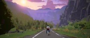
“And from the top, you get one of the best views of the city,” says Hall, as he manipulates Kassandra’s climb to the statue’s top. Kassandra turns south toward the Aegean. The game pans up toward a soaring eagle, then sweeps slowly across the expansive city and around toward the vista of rugged mountains, rolling seas dotted with postcard islands and a glowing sun slipping toward the horizon.
The view is as real as the maps used to create it.
Science & Tech
How nature is levelling up in video games, from playing as a raccoon to navigating ecological grief

People & Culture
Arctic sports and Dene games test pain resistance, agility and strength

People & Culture
With the 100th Grey Cup set to kick off this November, the Canadian Football League and its rough-around-the-edges charm is winning converts

History
Canada became a hotbed of gaming in the 1980s, for better or for worse