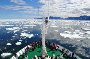
Ottawa’s St-Laurent Academy seems an unlikely setting for a re-enactment of a conflict that took place 200 years ago. After all, this sort of event is usually staged in fields, among stands of forest and even on water — not in a brightly lit activity room with canary-yellow walls.
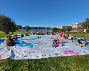
But on this snowy December day, their location isn’t stopping any of the grade-seven students filing into the room from imagining that they’re tramping over terrain that saw plenty of action during the War of 1812. The giant, richly illustrated floor map they’re walking across helps, of course, by pulling the students into — and onto — the story of the three-year conflict that helped shape Canada’s future.
The 11-by-8-metre map, produced by Canadian Geographic Education (CGE), depicts key battle sites along the border separating the then British colony and the northern United States. Step over here, and your left foot lands on Fort Henry, in Kingston, Ont. Step over there, and your right foot lands on Montréal. A few paces this way are familiar places the students have visited with their families — Fredericton, Halifax, New York City, Baltimore — while a couple of giant steps that way lies the vast swath of territory comprising the entire Hudson Bay drainage system, once known as Rupert’s Land.
Put yourself in front of a map, and it’s impossible not to become absorbed by it. On the surface, maps create an engaging portrait of a finite space — its places, people, events and landforms. On a more profound level, maps represent the starting point of every story about Canada. Like a good mystery, a good map provides clues and then invites creative and critical thinking about where we’ve been, where we’re going and how we can get there. “Thoughtful cartography is visual storytelling,” says Chris Brackley, lead cartographer at As the Crow Flies cARTography, the firm that designs the giant floor maps for CGE. “There’s no better way to distill the complex stories of Canada than with a map.”
Across most of the country, geography has been marginalized in elementary and high schools. But with its series of giant floor maps, CGE is reminding Canadians that geography matters, unfurling fascinating themes literally at our feet. By revolutionizing our understanding of what cartography can do, these maps are inspiring teachers and students to explore Canada in a novel way. “When a map fills a room,” says Brackley, “there is a physicality that changes your perspective, compared with when it’s all within the eye’s view. It’s a thrill to show something in a new way.”
To date, CGE has produced two of the huge laminated maps for circulation free of charge to Canadian schools: the War of 1812 map, created in partnership with the Government of Canada and the Department of Canadian Heritage, launched in September; a map showing all of Parks Canada’s sites, a partnership with Parks Canada, is due for release in April. A Boreal Forest map, co-produced with the Canadian Boreal Forest Agreement Secretariat, and an energy-sources map, in partnership with the Canadian Association of Petroleum Producers, will follow.
The art of the map
The cartographer’s art is typically restricted by the size of the finished product. So how does map-making change when the end result fills a large room? “In one way, it’s a familiar process,” says Brackley, “but what changes is how I interpret and visualize the information. The finished product is much more than a supersized regular map.”
Brackley begins by searching the vast digital archive of available data. The Government of Canada, a world leader in free mapping services, has an enormous inventory of what cartographers know as “base map datasets,” which show particular characteristics of the land. Cartographers use geographic information system (GIS) software to layer thematic datasets of various natural and human information, such as cities, roads, land cover or waterways, much as their predecessors used transparent Mylar sheets to sandwich map layers together.
After the base map is exported into design software, the creative work begins. Giant floor maps combine an artist’s decorative sensibilities with an editor’s eye for synthesizing information to a purpose-built theme. “You have to ensure that there is a good visual hierarchy so that everything is clear,” says Brackley. “You can hide things on a small map, but with a giant map, you can’t be vague.” An example is the thickness of roads or borders or choosing colours so that the text is legible over different types of terrain.
Brackley’s genius lies in how he gives each map a distinct visual character that embodies the theme. In the case of the War of 1812, the colours, backgrounds and typeface project an antique quality that situates the map appropriately in history. By contrast, the dense emerald green land cover on the Parks Canada map is studded by turquoise waterways and captures the splendour of our country’s natural heritage. “Maps should evoke the place,” says Brackley. “You always try to choose colours and a style that reflect the experience of being there.”
Geography at its best
A groundbreaking article appeared in the Journal of Geography more than a decade ago. In it, Charles Gritzner, now a professor at South Dakota State University, famously described the nature of geography and its value to everyday life with a thought-provoking definition: “What is where, why there and why care?”
In a technology-dominated world of powerful digital tools such as Google Earth and GIS, it may seem counterintuitive that a simple print product like a map could help students answer Gritzner’s questions and understand their role in the world. But, as Jeff Grove notes, technology has its pitfalls. “One of the problems with electronics,” he says, “is that there are too many temptations and diversions competing for the students’ attention.”
A print map, however, encourages students to focus and share, regardless of their learning style. “In teaching, we have to approach a subject from a hundred different angles to meet everyone’s needs,” says Anne Smith, a geography instructor in the faculty of education at Queen’s University, in Kingston, Ont. “I’ve seen kids who’ve held back all year in class suddenly show a leadership role in explaining an idea when the giant floor maps have been used in a lesson.”
The multi-layered storytelling of the giant floor maps also invites students to dig into Gritzner’s definition of geography. For example, they can trace the path of an oil pipeline and see the impact it will have on local communities and the environment or plot the migration of endangered species in Canada’s wilderness and better understand why those areas need protection. Brackley believes this depth of understanding is what makes printed cartography such a powerful tool. “On one level, you want people to get something out of a map by just seeing it without a legend — it’s the experience of that immediate quick hit,” he says. “The flip side is that you can sit and ruminate with a map, and that’s the enduring aspect. If it’s a rich map, there are insights to be gained over a lifetime.”
How to order the giant floor maps
The giant floor maps are available to schools across Canada, free of charge. The map of the War of 1812 is available until 2015. Bookings for the National Parks of Canada and the energy-sources maps begin in April and May, respectively. Starting in September, there will be limited availability of the Boreal Forest map. For information on how you can obtain these resources for your school or to register a booking date, visit education.canadiangeographic.ca.
Secrets of the trunk
Each giant floor map arrives with a trunk full of teacher-support materials that the Canadian Geographic Education team developed, including a binder of 10 classroom activities and lesson plans, which are based on the Canadian National Standards for Geography and serve the curriculum needs of every province and territory for kindergarten through grade 12.
The trunk also includes a host of innovative gadgets and replica items to engage students. In the War of 1812 trunk, for instance, a classroom activity entitled “A Tale of 20 Battles” comes with cue cards and coloured mini pylons so that students can mark key battles while they present information to classmates. The Parks Canada map will come with similar tools to help students explore wildlife species, habitats and migratory patterns, as well as forests, bodies of water, the Arctic and ways in which our parks tell the story of the rise of a nation. “The trunks are a great accompanying resource,” says Jeff Grove, a teacher. “They guide you but are flexible enough for teaching whatever comes up.”
Three stages of the War of 1812 giant floor map which debuted in Ottawa on Canada Day last year (Maps: Chris Brackley/Canadian Geographic)