Exploration
Tracking a 37-day expedition in the Monashee Mountains
Reflecting on an epic 600-kilometre ski traverse across the southeastern B.C. range and charting human and wildlife activity along the way
- 1591 words
- 7 minutes
Exploration
A behind-the-scenes look at the adventures and discoveries of the passionate explorers funded by the Royal Canadian Geographical Society

It was the second week of July 2022. Noah Booth looked out at 360 kilograms of packs, food and canoes dumped onto the Northwest Territories floodplain and knew the task ahead was ambitious.
Over the next month, Booth — along with his childhood friend Alex Traynor and brothers Kyle and Graham Ereaux — planned to canoe about 850 kilometres, mostly upstream, through the Northwest Territories and Nunavut until they reached the Arctic Ocean.

“The Arctic has appealed to us for a long time,” explains Booth, 31, who has completed a canoe trip every summer with Traynor since they were kids growing up in Nova Scotia. “We wanted to see as much as we possibly could, and we thought the best way to do this was through a cross-section of the different ecozones up there.”
The route they designed for this Royal Canadian Geographical Society-supported expedition would take them through one of Canada’s most remote regions, beginning in the boreal forest at the east end of Great Slave Lake and moving north along Kaché Kaɂá, or Pike’s Portage, a historic route used by Indigenous people to reach caribou hunting grounds and, later, by trappers and explorers. Today, much of Kaché Kaɂá falls within the national park reserve Thaidene Nëné and is managed by the Łutsël K’é Dene First Nation, Northwest Territory Métis Nation, Deninu Kųę First Nation and Yellowknives Dene First Nation.
The paddlers planned to tour the Contwoyto River, where, in 1821, explorer John Franklin lost his notes and nearly died trying to cross the waters after a failed attempt to survey the Northwest Passage. Eventually, they’d wind into the Mara River, with its series of wind-exposed rapids and narrows, and then the Burnside River where they’d meet a swift downstream current to whisk them into the Arctic Circle. They’d set the finish line at Bathurst Inlet, a bay on the Arctic Ocean where a floatplane could land safely to carry them back to Yellowknife.

“We were going from a low height of land to a high height of land without ever making much of a descent,” says Graham. People familiar with canoeing in the area “thought we were nuts.”
First, though, the foursome had to get to their starting point at Kaché Kaɂá, about five kilometres from where the floatplane deposited them. It took them 10 hours and three trips, carrying up to 45 kilograms a time, to shuttle their gear to the campsite at the water’s edge.
That night, they fell into their tents, exhausted and hot, the first of 29 nights they’d spend baking in their sleeping bags under the northern sun’s ceaseless summer rays.
The next morning as they prepared coffee, Booth heard a clip, clop, clip, clop sound at the edge of their campsite, like a horse trotting on pavement. About 20 metres away, he spotted a giant muskox sauntering across a rocky outcrop, its long hair swaying like “some sort of goddess,” he says. None of the four had seen a muskox before, though the animal was high on their list of must-sees. They stood in awe and watched the animal, a combination of ice age survivor and modern star of a shampoo commercial.

But once it moved on, they kicked into gear. The group knew they needed to maintain a relentless pace — an average of 32 kilometres a day — to make it through their planned route on time. They’d chewed up every vacation day they could spare from their day jobs — geologist (Booth), marketer (Traynor), tree planter and musician (Graham Ereaux) and lawyer (Kyle Ereaux) — and they had return flights booked out of Yellowknife.
The first five days of the journey were sunny and windless as they pushed their way along Kaché Kaɂá, through nine chilly lakes and over eight grueling portages. They began to question if their three bottles of sunscreen were enough under the sun’s bright rays.
Their next big challenge: three of the largest lakes in the region — Artillery, Clinton-Colden and Aylmer lakes. They hoped to move quickly through these bodies of water, with the goal of covering 40 to 50 kilometres a day to make up for lost time.
As the foursome neared Artillery Lake, they expected to see blue-grey waters, trimmed by a sky of a similar shade and a rocky shore. Instead, they found a surprise: a white expanse stretched out before them.

Ice break-up always lingers into the summer in the North, so the group was prepared for some ice — but not like this. And as they pressed on, the ice floes grew larger, blending into one frozen sheet. On the horizon, the paddlers saw what appeared to be a milky blue glacier.
The ice forced the canoes to shore. The group clambered out of their boats and climbed a small hill to look out over the lake and plan their route of attack. As they passed a set of binoculars among themselves, trying to figure out how to navigate past the glacier ahead, they realized something: the glacier was a mirage, created by the contrast between the hot summer air and the cold winter ice pack. There was no glacier, only ice as far as the eye could see.
“We realized then that we were contending with what would end up being a pretty large hurdle that we would have to overcome,” says Graham.
Ice has always been a defining factor for travel in the region. Subarctic Indigenous peoples originally used snowshoes, sleds and toboggans to travel distances in winter and switched to canoes once the ice had thawed. Warburton Pike, an eccentric explorer from England for whom Pike’s Portage is named, explored Canada’s North in the 1880s and ’90s and wrote two books about his expeditions. In them, ice is a recurring character, upending the plans of anyone seeking to travel through the area.
More than a century and a quarter later, Booth and team, despite their modern equipment, found themselves confounded by the same barrier. “It’s very humbling to see how ice still dictates all sorts of travel up there,” says Booth.

Ice continued to bedevil them. They spent much of the next week walking around the shoreline and pushing ice out of their way. “It was super slow,” say Booth. The canoeists pressed on, knowing that, with one windy day, the ice could blow apart and open passage for them. But the wind never arrived.
“There’s nothing we could have done. We just had to sit and watch and go with the flow of nature,” says Booth.
They hoped that the next stage of the journey through the Back River, with its 50-kilometre downstream stretch, would change their fortunes. It wasn’t to be. When they arrived, they found a dry riverbed. Instead of the single day they’d planned to travel the river, they spent three days portaging through the area.
Two weeks into the trip, the foursome made the difficult call: they would end their adventure somewhere short of the Arctic Circle.
The decision set off a “philosophical conundrum,” says Booth. “We were trying to figure out what the point of doing a trip is when the purpose of the trip has been pulled out from under you.”
They committed to slowing down, sometimes travelling only 15 kilometres a day, and taking in the small scenes they’d been too busy to enjoy in the first two weeks. One morning, while camped on an island, they pulled out a magnifying glass and studied different types of lichen, marvelling at how slowly it grows yet still survives in harsh conditions.

The four men were struck by how far they could see once they were in the barren lands without trees for perspective. Mountains in the distance looked gargantuan but proved quite tiny by mountain standards as they drew close. The air—free of pollen, dust and pollution — felt extra crisp.
“It was the land of opposites,” says Graham. “You have these massive, massive landscapes. But if you want to sit down and soak up nature, that [means] looking at the smallest details, like how lichens form on rocks or the tiniest plants that are somehow surviving up there.”
One day, they noticed odd black specks in the distance: a herd of muskox, running, their thick manes bouncing.
At the same time, the paddlers observed a notable presence of death. They frequently spotted animal bones that had neither decayed nor moved over time — they had remained frozen in place for years.
In the evenings, they fished to supplement their carefully planned, 3,000-calorie-per-day diet. They caught and feasted on different varieties of trout, fatter and bigger than what they were used to back home. The lakes felt “very alive,” says Graham, perhaps more akin to what rivers in British Columbia were like before overfishing and climate change affected life in its waters. But even with the abundance of fish, the team was burning calories at a rate far beyond their caloric intake. They lost two to seven kilograms each over the four weeks.
They ended the trip at Contwoyto Lake, which they estimated to be 300 kilometres short of their planned finish. And they’re already considering a return trip. Like Warburton Pike, they’re waiting for the right moment when Mother Nature clears a route for them.
“One lesson I consistently learn on these trips is how important patience is,” says Booth. “Sometimes I just want to go and do the hard work. But there’s nothing we could have done.”
Deep in the Monashee Mountains of British Columbia lies a unique cave system. Known as the White Rabbit karst, this series of caves is more than eight kilometres long, with some as deep as 600 metres underground. A team of cavers led by Kirk Safford are seeking to cover new ground, exploring previously unexplored passageways and digging through the rock to connect two of the larger caves. In the process, they hope to achieve a new Canadian depth record. The team started their work in January 2022 and are set to finish later this year. Here’s a peek at their progress.
Team members: 9
Digs undertaken to date: 10
Metres of passage dug: 21
Metres of rope needed to access digs in both caves: 116
Total metres of new surveyed passage: 214.6
Hours of digging undertaken in a busy September 2022: 80


The Great Island Expedition was a unique endeavour to document the historic shipwrecks, Second World War artifacts and underwater landscapes of Newfoundland’s fiords. For two weeks, a 15-member team of explorers investigated and shared the province’s hidden geography. The team, which included Royal Canadian Geographical Society Explorer-in-Residence Jill Heinerth, overcame frigid temperatures and murky waters to log a remarkable discovery.
On Sept. 4, 1943, a Second World War-era B-24 Liberator bomber (dubbed “Liberator 589D”) crashed upon takeoff into Gander Lake, taking the lives of all four crew. Search and salvage missions were conducted by military divers in diving helmets but abandoned when the bomber slipped off a steep ledge and disappeared into the depths of the lake.
Wing Commander J.M. Young, Squadron Leader John Grant MacKenzie, Flying Officer V.E. Bill and Leading Aircraftman G. Ward perished when the engine failed on takeoff and the aircraft plunged into the lake. The body of MacKenzie, from Lucknow, Ont., was the only one originally recovered. He is buried in the Gander cemetery.
The Royal Canadian Air Force had rough coordinates from the original crash report 80 years ago. In July, the Shipwreck Preservation Society of Newfoundland and Labrador found the plane’s exact location using multibeam sonar and made 3D images of the wreck. On Sept. 5, 2022, the Great Island Expedition team made six challenging dives, managing to locate the aircraft in ice-cold, murky conditions.
The wreck’s identity was confirmed through a series of artifacts, including a small landing light on the wing, a turbo launcher, a turret and ammunition belts. The team passed along sketches, video and images to the Shipwreck Preservation Society, the Department of National Defence and the RCAF. The RCAF will determine what happens next.


On a cold May morning, friends Amaya Cherian-Hall and Heather Waterous set off on an epic journey from the Targhee Pass trailhead in Idaho. The duo, who have been adventuring together since meeting in 2015 at university in Squamish, B.C., planned to spend five months on the road, hiking, biking and canoeing through the traditional territories and lands of more than 20 First Nations and Métis while taking in the breathtaking landscapes of the famed Yellowstone to Yukon corridor. Along the way, they’d visit the popular geysers of Yellowstone, experience the wonders of
the Rockies and paddle parts of the mighty Yukon River. Unfortunately, an achilles injury for Cherian-Hall and a knee injury for Waterous forced them to re-evaluate their goals mid-expedition. They abandoned much of the planned hiking and cycling section beyond Banff, instead road-tripping to Whitehorse to finish up with a nine-day canoe trip down the mighty Yukon River to Dawson. It was, they reported on Instagram, “a pretty phenomenal way to wrap up a summer of adventuring, growth, big emotions, friendship and love.”
“I love being in the Arctic in winter because the light has a different feel when the sun is just barely cresting the horizon,” says adventurer and RCGS Explorer-in- Residence Ray Zahab. In March 2022, Zahab and fellow extreme athlete Kevin Vallely hitched their sleds behind them and set out from Ausuittuq (Grise Fiord) at the southernmost point of Umingmak Nuna (Ellesmere Island), Nunavut, with the goal of completing a 50-day, 1,000-kilometre expedition on ski and foot to Alert. Joining them for part of the journey was a small support team of filmmakers and locals. Here’s what happened.

In the Arctic winter deep freeze, temperatures reached estimated daytime highs of -30 C and night- time lows of -50 C. These frigid temps were hard on the body in more ways than one. The snow became incredibly abrasive, says Zahab, and hauling a sled felt like dragging it over large chunks of glass.
The duo’s original plan of covering 20 to 25 kilometres a day quickly fell apart. When they tried using snow machines (small motorized sleds) to carry some of their gear, they immediately encountered another problem — the snow machines refused to start in the frigid temperatures. Zahab and Vallely quickly realized the expedition was becoming unsafe for everyone, and they made the tough call to end it at Vendom Fiord.
Despite Zahab and Vallely’s disappointment, this project was never about testing their endurance. Instead, it was more important for the pair to interact with the community and the land. “These projects where we’re given an opportunity, in this day and age, to be able to connect, make new friends and learn about a place from the people who live there every day,” says Zahab, “that’s the more meaningful part of the expedition now for me.”
The modified plan is for the team to return to Ausuittuq in March 2024 to complete the expedition by foot and dogsled. In the meantime, Zahab has plans to travel to the eastern Arctic and to the Suguta Valley in Kenya.


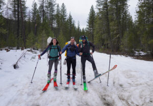
The powder-laden Monashee Range is a popular playground for outdoor adventurers looking to heli-ski down its scattered peaks and sled through its sweeping alpine valleys. But for Isobel Phoebus, Stephen Senecal and Douglas Noblet, the Monashees were home for 37 days from April to May 2022 as they traversed the entire length of the range by ski, linking together high-traffic areas and more remote sections. All told, the team undulated their way across 605 kilometres and 42,000 vertical metres from Grand Forks to Clemina Creek, B.C., observing and recording human and wildlife activity. Here, Phoebus, expedition lead and wildlife biologist, recounts the most memorable moments along the route.
“In two decades of travel, doing large expeditions, Pikialasorsuaq was where I most felt like I was on the edge of the planet,” says wildlife ecologist and adventurer Dave Garrow.
In May 2018, Garrow and his fellow mountain adventurers Frank Wolf and John McClelland skied into Pangnirtung, Nunavut, having descended from Baffin Island’s Penny Ice Cap, and noticed something surprising. Dozens of people from the community were on snowmobiles and qamutiiks, heading out of town to hunt, fish and travel. Not towards the 2,000-metre-high ice cap, but in the other direction. Towards the floe edge, where ice and open water meet.

“It opened my eyes,” says Garrow. “I recognized then that the true story of the North is one of sea ice.”
From there, the Pikialasorsuaq Expedition was born. Garrow, Wolf and McClelland set out on May 5, 2022, from Ausuittuq (Grise Fiord), Ellesmere Island, on a 310-kilometre ski traverse aiming to explore, document and research the North Water Polynya, a massive area of open water surrounded by sea ice. The name of the expedition, Pikialasorsuaq, is the Kalaalisut (West Greenlandic) name for the North Water Polynya and translates as “the Great Upwelling.”
“This was really an expedition focused on better understanding sea ice,” says Garrow, “and bringing stories of sea ice and the changes we’re seeing to Canadians.”
Wedged between Umingmak Nuna (Ellesmere Island), Tallurutit (Devon Island) and Greenland in the northern reaches of Baffin Bay, Pikialasorsuaq is the largest polynya in the Arctic. Open year-round, at its peak it spans up to 85,000 square kilometres — about the size of Ireland. It’s an oasis in a frozen desert. Plankton drift in the water column. Shrimp feed on them and are in turn fed on by char and cod. Beluga, bowhead whales and ringed seals peruse the buffet, take their pick, then vanish. Polar bears lurk. This is one of the most biologically productive regions north of the Arctic Circle.
For Garrow and his expedition mates, sea ice was a completely different dynamic to the sturdy glaciers they were accustomed to as experienced mountain travellers.
Terry Noah, Qikiqtaaluk Inuk and operator of outfitting and guide service Ausuittuq Adventures, and his assistant Nolan Kiguktak transported the team from Ausuittuq to Ward Point on the northern coast of Tallurutit. They shared long-held knowledge critical to understanding sea ice conditions, prevailing winds, polar bear travel corridors and how to move safely through their habitat.

In spring, polar bears mostly rest among scattered ice heaves during the day, when Garrow and company would be on the move. Noah and Kiguktak warned them to navigate the larger heaps of ice with caution lest they come face-to-face with a startled bear. But in the heart of polar bear country, encounters of some kind are inevitable.
“Each night after dinner, we’d come out of the tent and have whiskey and some chocolate,” says Garrow. “As we piled out [one night], I glanced over my shoulder. And there, about 50 feet from the camp, was a nine-foot polar bear.” Twenty minutes of curious investigation later, the bear left them to their nightcap, off to find itself a ringed seal or two.
They divided the expedition into three legs: first, sea ice travel from Ward Point to — and then along — Pikialasorsuaq’s edge, before crossing the Devon Ice Cap and exiting via the Sverdrup Glacier. Then, back to Ausuittuq via Cape Hardy and Jones Sound.
Each leg provided its own set of thrills and challenges, but the first
was what Garrow called the technical crux of the expedition — the edge of the polynya.
“When you see images of the floe edge, it’s quite calm,” says Garrow. “People are sitting in lawn chairs, watching whales go by. That wasn’t our experience.”
The team spent a day travelling less than 20 metres from the edge of the polynya, about six kilometres offshore and skiing on a mere 1.2 metres of ice, before retreating satisfied to a safer distance. “There was so much wind that the sea spray was hitting us from 60 feet away, and you could actually see chunks of ice shearing off as the wind grabbed them. It felt like being on the summit of a mountain for far too long.”
Pikialasorsuaq and its surrounding sea ice form a life-supporting and dynamic environment — and an increasingly fragile one. Garrow and his teammates left Pikialasorsuaq with a new perspective and, through storytelling, an aim to bring more Canadian eyes and ears to this vital ecosystem. They saw that the sea ice is changing, becoming increasingly unstable, and it kept them in a state of uncertainty. Yet it was only a glimpse of what is being experienced by the people for whom sea ice has been an infrastructure and an extension of their working land for millennia.
“That day, we’d been grinding against the wind all day long,” says wilderness traveller, photographer and veteran Arctic adventurer John Dunn of this sunny scene on Umingmat Nunaat (Axel Heiberg Island), Nunavut. “If you look down on Wolf Valley from a satellite picture, it’s the most amazing looking place with glaciers all coming down. But when you’re grinding up there in the late winter or early spring with a sled, you don’t appreciate that quite as well.”
That deceivingly windy day in the Wolf Valley marked the end of the first week of the Double Axel Expedition, which saw Dunn and Dr. Graeme Magor, a medical doctor and fellow adventurer, complete a roughly 900-kilometre ski traverse of Umingmat Nunaat from south to north and back again. The duo left Sherwood Head at the southern tip of the island on April 29 armed with their skis and sleds packed with some 100 kilograms each of gear and food.
On June 7, they reached the northernmost point of the island — and began their trek back down, finishing at Buchanan Lake on June 26, just shy of their starting point.


This story is from the January/February 2023 Issue
Exploration
Reflecting on an epic 600-kilometre ski traverse across the southeastern B.C. range and charting human and wildlife activity along the way
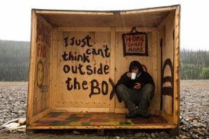
Travel
An insider’s account of the modern-day gold rush
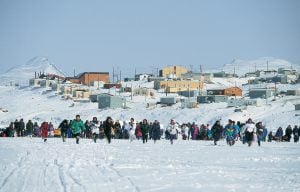
History
On April 1, 1999, Canada’s youngest population took control of its largest territory. Here’s how Canadian Geographic covered the story.

Exploration
From coast to coast to coast and into the ocean as well, eight grants expand our understanding of Canada