Exploration
The 2022 Expedition Insider
A behind-the-scenes look at the adventures and discoveries of the passionate explorers funded by the Royal Canadian Geographical Society
- 3864 words
- 16 minutes
Exploration
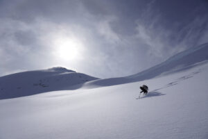
Reflecting on an epic 600-kilometre ski traverse across the southeastern B.C. range and charting human and wildlife activity along the way


As I gather thoughts to provide a genuine sense of our expedition, useful information or inspiration, I ponder over a way to transform my experience into something valuable. My mind comes to the deeper meaning behind this traverse, one I hadn’t expected when I originally signed on for up to 42 days of backcountry ski touring with Douglas Noblet and Stephen Senecal.
My high school dream was to work onboard a research vessel travelling somewhere far from my home — a real scientific expedition — though I was never clear on how I’d get there. Since then, I’ve become a wildlife biologist, working many remote field seasons and taking steps in the right direction. That dream has now evolved into bringing my professional and recreational expertise to expeditions that combine science, technical mountain skills and nature conservation.

When Douglas Noblet, a friend from kindergarten, first told me about his ski traverses of the Selkirk and Purcell mountain ranges in southeastern British Columbia with Steve Senecal, I was instantly intrigued. It felt beyond my abilities (I didn’t even ski tour yet), but I admired their tenacity. Two years later, when Douglas brought up their plan to traverse the Monashees in the spring of 2022, my thoughts started firing. Could I join them? Would I have time? Am I physically and mentally strong enough? That day, I cautiously hinted at the possibility of joining them for a section of the trip.
The idea of completing the entire traverse stayed in my mind and, eventually, I joined the team. After learning about the Royal Canadian Geographical Society’s Expedition Grant, I was excited to add new meaning and value to the adventure by incorporating a survey of human and wildlife activity. I could bring my unique professional knowledge to the team, develop my snow tracking skills and contribute to the conservation of threatened species.
First, we had to come up with a plan. Organizing logistics for our route through the Monashees took months. We spent hours poring over satellite imagery, reading guidebooks and online resources, acquiring knowledge from locals to the area, planning food drops and crunching lots of numbers: total expedition days, segment lengths between food caches (kilometres, elevation gain and days), calories per day, litres of cooking fuel, weight of gear on our backs, and the acceptable minimum number of treats. Then it was time to put all our planning to the test.

April 1, 2021, day one of our expedition. The tiny city of Grand Forks, B.C., on Highway 3 just north of the Canada-United States border, bike pedals under foot, no snow in sight. We cycled 45 kilometres before reaching the Monashee alpine expanse. Once we donned skis, our track followed closely as planned, with a few variations due to weather and conditions. At the start, my expectations for wildlife tracks were low. I imagined animal numbers would be limited, and the remoteness would keep humans away, but there were ample tracks and signs to keep me busy. Constantly on the move, I balanced continuous travel with quick identification. Each day I scribbled in my notebook and filled data tables, recording signs of wildlife (e.g. sightings, tracks, scat), human recreation (e.g. ski tourers, snowmobile tracks) and industrial activity (e.g. forestry harvest blocks, roads). On our first six-day leg, I began by counting the specific number of each animal signs I observed. Day five saw signs of 94 marten, 38 snowshoe hare, 30 squirrels, 10 mice/voles and four felines. And that was just mammals. It didn’t take long to realize that memorizing so many numbers on repeat while skiing was too much, so I shifted to recording daily species presence instead.
During the southern portion (days 1-19), our most frequent feathered friends included chickadees and varied thrushes, with rare sightings of Steller’s jays, dippers and mountain bluebirds. Common mammal tracks included canine, feline, marten, squirrel, hare and mouse or vole, with rare deer and moose tracks. Our excitement spiked at the first wolverine tracks near Mount Odin at the start of the Gold Range. We passed ski lodges, heli-ski tracks, ski tour tracks, snowmobile tracks and even met people along the way. We also passed many forest harvest blocks and travelled along forestry roads.


We witnessed a substantial change in environment between the first and second half of our traverse; Grand Forks to Revelstoke had fewer, mellower mountains, while Revelstoke to Valemount brought us through big remote glaciated terrain. In parallel, there was a stark difference in certain wildlife (Figure 13) and human activity (Figure 14).

After crossing the Trans-Canada Highway near Revelstoke, signs of other humans nearly vanished (days 20-37). We were on our own. The ski lodges were replaced with an abandoned mine exploration camp. Heli-ski runs were left untouched. We were out of reach from ski tourers and snowmobilers. Instead, the mountains gifted us with new species tracks. Adding to our list we identified porcupines, small weasels, black bears, pikas and mystery tracks (see “Uncovering Mystery Tracks” below). Our typical views were of mountains with glaciers and drainages, and forestry harvest blocks in the distance. Most notably we were in prime wolverine habitat, evidenced by the presence of tracks on 12 of the 18 days in this section and two wolverine sightings (see “Charged by a Wolverine”). We submitted 51 wolverine locations to Wolverine Watch, and I am now assisting a wolverine research project.
The combination of a ski traverse and a scientific transect along an entire mountain range provided me with an opportunity for greater learning, while developing a stronger connection to the landscape. By the time we reached the finish line in Valemount, B.C., after covering more than 605 kilometres, I felt like I truly explored the Monashee mountains, its wildlife and how we humans use the area. Part of my longtime dream was realized, and my desire to interweave technical expeditions with science and conservation, reaffirmed.
The Complete Monashee Ski Traverse: 3 people, Grand Forks to Valemount over 605 km, 42,000 m elevation gain, 37 days, 289 hours on the move, at least 150 cm of fresh spring snow, 31+ species, 4 cabins, 2 ski lodges, 1 abandoned mine camp, snowmobile tracks, ski tracks, harvest blocks, roads, glaciers, mountains, and so much more.

On a cold and sunny morning, we climbed through an alpine col, followed by a descending traverse and an ascent to yet another col. I was in front, with Steve a few hundred meters behind me, and Isobel another few hundred meters behind him.
Having worked through a short, steep section, I was landed on a terrain bench peppered with large boulders. About 50 metres ahead, I noticed an animal walking up to one of the boulders. “Look at that big marmot,” I thought to myself, “…wait, don’t marmots hibernate during the winter?”
I then realized what I was looking at — a wolverine! It spent some time checking out the boulder, then ran down towards me. It didn’t take long before I felt the need to make my presence known, so I started speaking loudly. Still, it continued in my direction. Finally, when it was about 30 metres away, it stopped.
The animal – like a housecat, back arched and fluffed tail – looked at me for a few seconds. It then bolted off to my left, stopped, looked at me again. It did this about five times before cresting a small knoll and vanishing out of sight.
Minutes later, when Steve arrived (having missed the sighting), we skied to the knoll and saw the tracks headed all the way to valley bottom. It was an experience I will remember forever.
—Douglas Noblet

After a 4:15 am departure and a few hours of travel over crusty snow, we stopped for a break at the intersection of two valleys. As I munched on my snacks, I noticed many large footprints. They looked like moose tracks, but at 1,500-metre elevation with soft, deep snow — it seemed unlikely. I roamed around to investigate, looking at the prints for particular characteristics, pocketing a hair sample and noting the track behaviour. We carried on, and I kept my thoughts to myself.
The tracks returned as we entered a narrow creek drainage. They flowed over a snow roll and then converged to cross the steep slope we were ascending, all stepping in line to form one set of efficient tracks. I veered off our trail to follow them. My excitement grew as I found more evidence —a few exemplar tracks, well rounded and wide with evident dewclaw (rear toe) marks. Continuing up the creek, we passed another set of tracks headed down valley. At top of the drainage, the two directions overlapped and a new species joined the party — wolverine, also looking fairly fresh. I then saw evidence for a definitive I.D. for the mystery tracks: a cluster of small dark pellets, about one centimetre in length. It certainly didn’t belong to a strange herd of alpine moose.
“Caribou!” I exclaimed to Douglas, who was waiting for me at the edge of a snow-covered lake. There we counted eight beds, with more pellets, urine and hair. Later, a caribou biologist friend informed me that the tracks were on the boundary of the Groundhog and Columbia North caribou herd ranges. Back at the lake, the tracks stopped. It was as if the herd had come up just for a scenic alpine nap.
—Isobel Phoebus
Exploration
A behind-the-scenes look at the adventures and discoveries of the passionate explorers funded by the Royal Canadian Geographical Society

Exploration
From coast to coast to coast and into the ocean as well, eight grants expand our understanding of Canada

People & Culture
Food planning for ski trips — do we really eat that much in a month?

Science & Tech
As geotracking technology on our smartphones becomes ever more sophisticated, we’re just beginning to grasps its capabilities (and possible pitfalls)