Environment

Infographic: Understanding atmospheric rivers

A closer look at the mechanics of the intense rains they bring to the West Coast

[ Disponible en français ]
As the climate warms, the air holds more moisture and heat. Since 1980 alone, that has made atmospheric rivers more frequent, larger and moister. They will become even more intense as the planet heats up even more. (Photo: Abhishek Tewari/Unsplash)
Expand Image
Advertisement
Advertisement
Advertisement

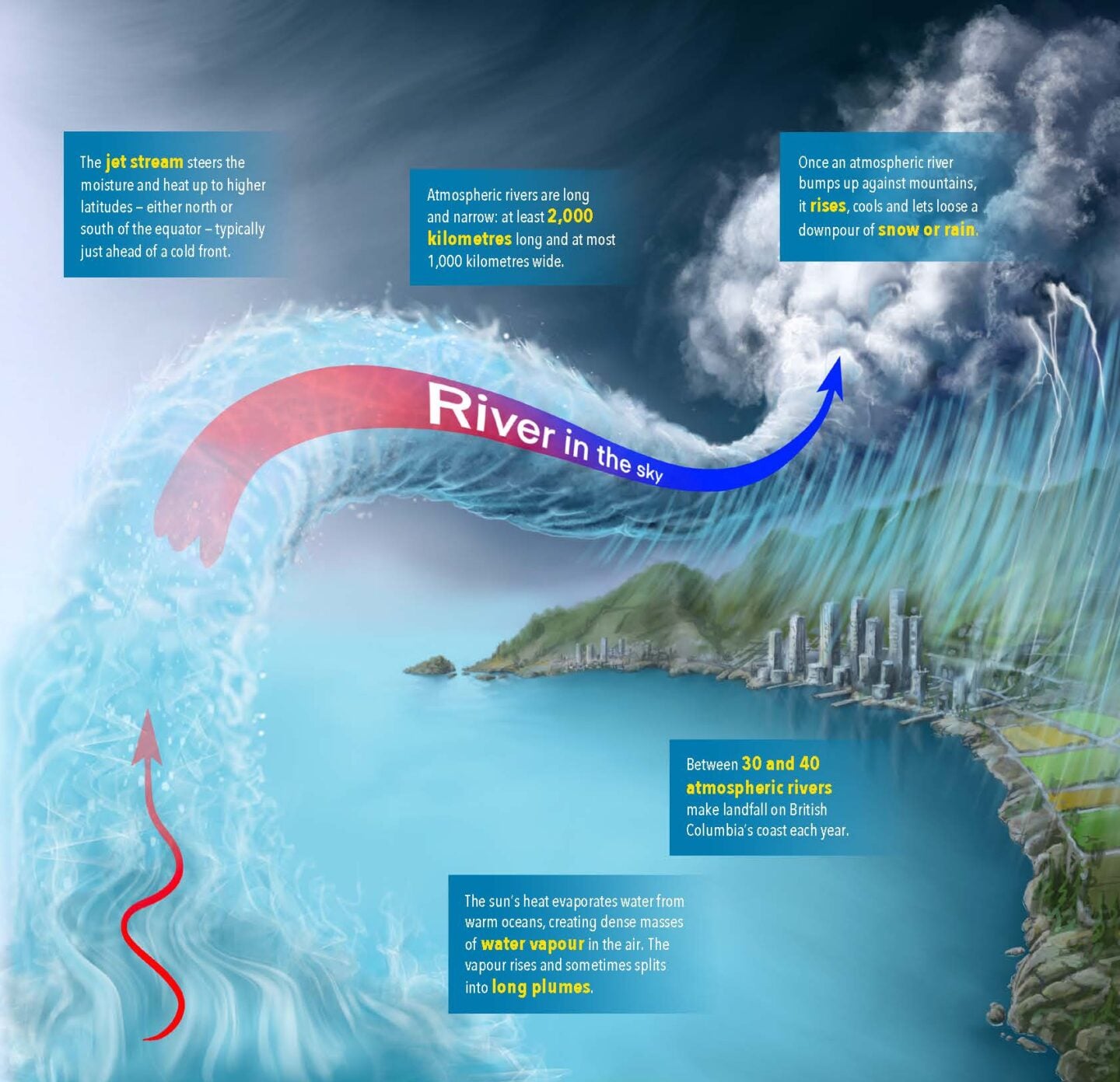
If it seems like the term “atmospheric river” has only recently leapt into everyday vocabulary, that’s because it has. It got its formal definition from the world’s meteorological community in 2018. To wit: a long, thin, transient corridor of water vapour flowing from low latitudes to higher ones, not far above Earth’s surface.

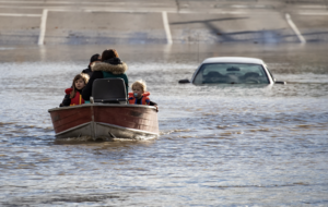
But for Canadians, the idea that the sky could let loose a river hit home hard in November 2021. That’s when a catastrophic atmospheric river struck the south coast of British Columbia and just kept going. Two and a half days later, it had led to the deaths of at least six people, the evacuation of nearly 15,000 and the deaths of 1.3 million farm animals. Buildings shook in the strong winds, sides of mountains broke away, bridges collapsed in the floods, Highway 8 fell into the Nicola River, and sections of the Coquihalla Highway were closed for months.

If the nomenclature is new, the phenomenon is not. Weather scientists have been tracking these streams of water in the sky for nearly a century. In the 1930s, they were called “moist tongues.” Later, they were “warm conveyor belts” or “tropical plumes.” If it began off the coast of Hawaii and then hit the west coast of North America, it used to be known as a “pineapple express.”

Atmospheric rivers look different on weather satellites from typical storms: plumes instead of a comma or a cinnamon bun, says Bobby Sekhon, a warning preparedness meteorologist with Environment and Climate Change Canada, based in Vancouver. 

When they are extreme, they are like a giant firehose that won’t turn off. 

But not all atmospheric rivers are monsters. In fact, these plumes of warm vapour are one of the main ways that water and energy move around the planet. The sun’s heat evaporates water from warm oceans, creating dense masses of water vapour in the air. The vapour rises and sometimes splits into long plumes. Then the jet stream picks it up, carrying all that moisture and heat to higher latitudes — either north or south of the equator — typically just ahead of a cold front.

Once the mass bumps up against mountains, it rises, cools down and then lets loose its moisture. The river in the sky turns into a downpour of snow or rain as it makes land. Most are unremarkable, simply filling up Earth’s aquifers or replenishing pack snow on mountaintops.

But when they are extreme, they are like a giant firehose that won’t turn off. The volumes are astounding; some hold twice as much water as the Amazon River, the world’s largest. The amount of damage they cause depends on where they fall, how long they last, how saturated the land already is, and how many people and how much human infrastructure are in the area, says Sekhon.

And they are getting worse. As the carbon load in the atmosphere heats the planet, the air holds more moisture and heat. Since 1980 alone, that has made atmospheric rivers more frequent, larger and moister. They will become even more intense as the planet heats up even more.

This story was created in partnership with Environment and Climate Change Canada.

Weather scientists have been tracking atmospheric rivers for nearly a century. In the 1930s, they were called “moist tongues.” Later, they were “warm conveyor belts” or “tropical plumes.” If it began off the coast of Hawaii and then hit the west coast of North America, it used to be known as a “pineapple express.” (Illustration: David Wysotski/Can Geo)
Expand Image
Advertisement

Help us tell Canada’s story

You can support Canadian Geographic in 3 ways:

Related Content

Environment

Canada has a new weather alerting system. Here’s what the colours mean — and what to do when severe weather strikes

Environment and Climate Change Canada has launched a new colour-coded system for its severe weather alerts. Here’s what you should know.

  • 2512 words
  • 11 minutes

Science & Tech

Is it “normal,” or is it climate change? Understanding Canada’s weather extremes

Known as the Rapid Extreme Weather Event Attribution system, a new program from Environment and Climate Change Canada measures how global warming affects our local weather

  • 1449 words
  • 6 minutes

Science & Tech

Flying through Arctic storms in the name of science

Zen Mariani explains the ground-breaking Polar Night Experiment, plus more atmospheric stakes in the Far North

  • 1622 words
  • 7 minutes

Environment

Q&A: A Canadian river conservation leader on protecting our waterways

Mark Angelo, founder of BC Rivers Day and World Rivers Day, shares insights on his love of rivers, his forthcoming film and what can be done to protect the planet’s waterways

  • 1092 words
  • 5 minutes
Advertisement
Advertisement