Environment
The research project trying to find every tornado in Canada
Tracking the country’s extreme weather events to answer the question: are storms getting worse?
- 3514 words
- 15 minutes
Environment
Environment and Climate Change Canada has launched a new colour-coded system for its severe weather alerts. Here’s what you should know.
It was going to rain; Robyn Roste knew that much. Roste lives in Abbotsford, B.C., but on Nov. 14, 2021, she and her husband were on vacation in the Rockies. What they didn’t know, as they set out from Canmore, Alta., for Fairmont Hot Springs, B.C., was the table was already set for a once-in-a-generation storm that would devastate much of southern B.C. The culprit was an atmospheric river, which, until that fall, Roste had never heard of and thought sounded made up.
Under normal circumstances, atmospheric rivers — long, narrow flows of concentrated water vapour with twice the flow of the Amazon River — carry beneficial moisture from tropical oceans to the coasts. They contribute to the alpine snowpack, which provides water to communities and ecosystems downstream, and have been responsible for ending major droughts up and down the west coast of North America. But 2021 had been anything but normal in British Columbia. Early in the summer, the province sizzled under a record-smashing heat dome. Fires ripped through tinder-dry forests, leaving burn scars that were less able to absorb the autumn rains, which arrived with a vengeance.
“It rained and rained and rained and then it rained more,” recalls Roste, who works as a freelance editor and marketing consultant for various non-profits. “When you do the math through the seasons, there’s a lot of signs that things are going to go wrong. But of course, we didn’t recognize it, because we’ve never been through this.”
In advance of the storm’s arrival, Environment and Climate Change Canada meteorologists issued a special weather statement for southern B.C., cautioning that the incoming heavy rain on top of all the rain that had fallen previously, as well as melting snow, could cause localized flooding and elevated river levels. But in a region accustomed to seasonal rains, provincial emergency managers refrained from issuing flood warnings or travel advisories.
As they drove south on Highway 93, Roste and her husband encountered heavy snow. Then, traffic stopped completely. Roste had no cell service, but drivers further ahead in the queue who had opted to turn around reported that between the snow and multiple vehicles that had spun out in the treacherous conditions, the road was impassable. Roste and her husband waited through most of the night, running the engine periodically to keep warm. Eventually, with their fuel running low, they decided to turn back.
“People just weren’t prepared. It caught everyone off guard … at every level, from government to homeowners.”
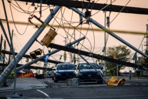
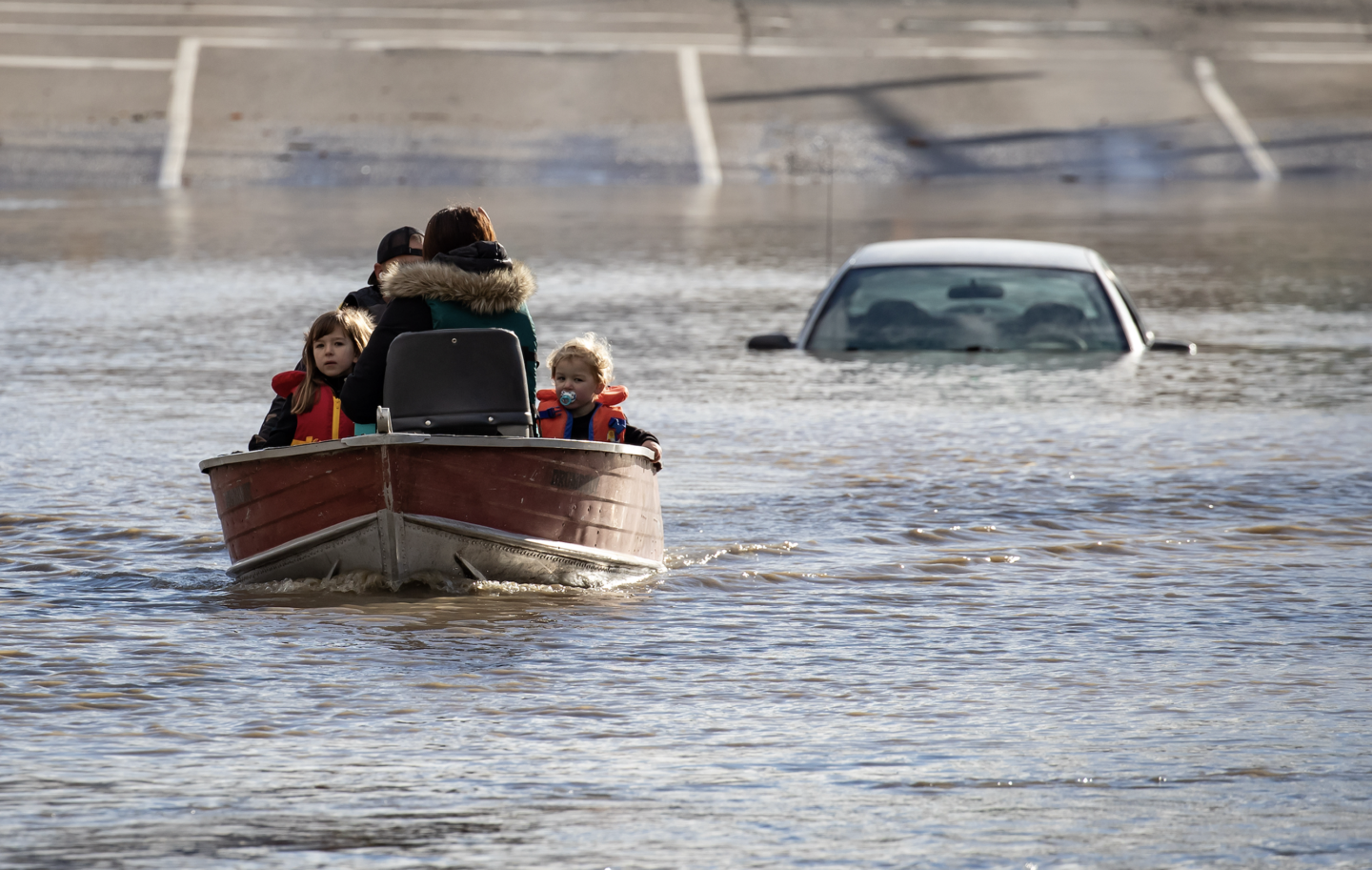
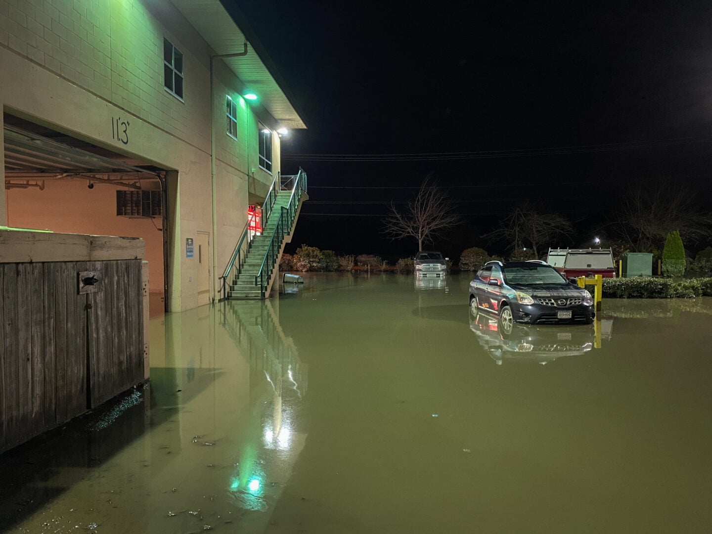
As dawn broke, their phones lit up with messages from home. Neighbours in Abbotsford had been advised to prepare to evacuate as the rain made the mountain slopes unstable. Slopes weakened by the summer’s drought and fires and saturated with rain and melted snow loosed mud and debris onto the highways below, eventually completely cutting off the Lower Mainland from the rest of Canada. Roste spent the day on the phone, getting updates and making plans to get her pets to safety if the worst came to pass. By nightfall on Nov. 14, nearly every major highway across southern B.C. was closed, blocking the transport of essential goods and stranding thousands of motorists who had headed into the mountains for weekend fun not realizing this storm would be the tipping point for a stressed environment.
“People just weren’t prepared,” says Roste. “It caught everyone off guard … at every level, from government to homeowners.”
For Bobby Sekhon, a Vancouver-based meteorologist with Environment and Climate Change Canada, the catastrophe that unfolded in southern B.C. through mid-November 2021 underscores the challenge forecasters face with every big storm: how to predict not just the weather, but its impacts.
“It’s always hard to say the extent of the damage that could occur,” he says, adding existing infrastructure problems can exacerbate the effects of a storm. In the case of this atmospheric river, “it was a lot of elements lining up that caused so much damage at the time.”
The need to better understand and communicate the risks associated with certain types of weather was the impetus for a major overhaul of Canada’s weather alerting system.
Previously, alerts were issued when forecast conditions were expected to meet a certain threshold — such as winds gusting to 90 kilometres per hour or more, or more than 50 millimetres of rainfall in an hour. But most people have little to no frame of reference for what these hazards mean in practice, says Jesse Wagar, a warning preparedness meteorologist based at Environment and Climate Change Canada’s Edmonton weather office.
“We can talk about 10 centimetres of snow, we can talk about 90 kilometre-per-hour winds, but for the average person who’s going to experience this weather, it can be difficult to apply that information,” she explains. “What are 90 kilometre-per-hour winds? Is that strong enough to do damage?”
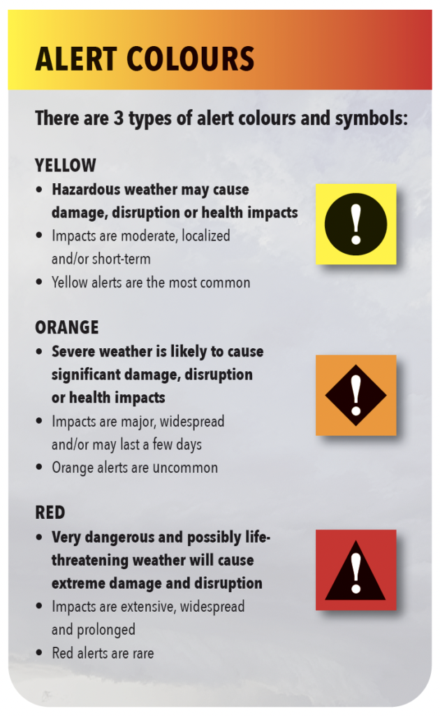
The new system, which launched at the end of 2025 and aligns with best practices set out by the World Meteorological Organization, instead uses different colours to alert the public to the expected impacts of the incoming weather, with yellow being the least severe but still impactful in the short term, orange for significant widespread impacts, and red for dangerous and life-threatening weather with extreme and long-lasting impacts. Under this new system, the B.C. atmospheric river would have been a red-level event, Wagar says. Ideally, that means everyone, from the public to municipal and provincial emergency managers, would understand the dangers posed by the incoming storm — and be ready to act.
“We really want to be able to empower people to make those decisions to protect themselves.”
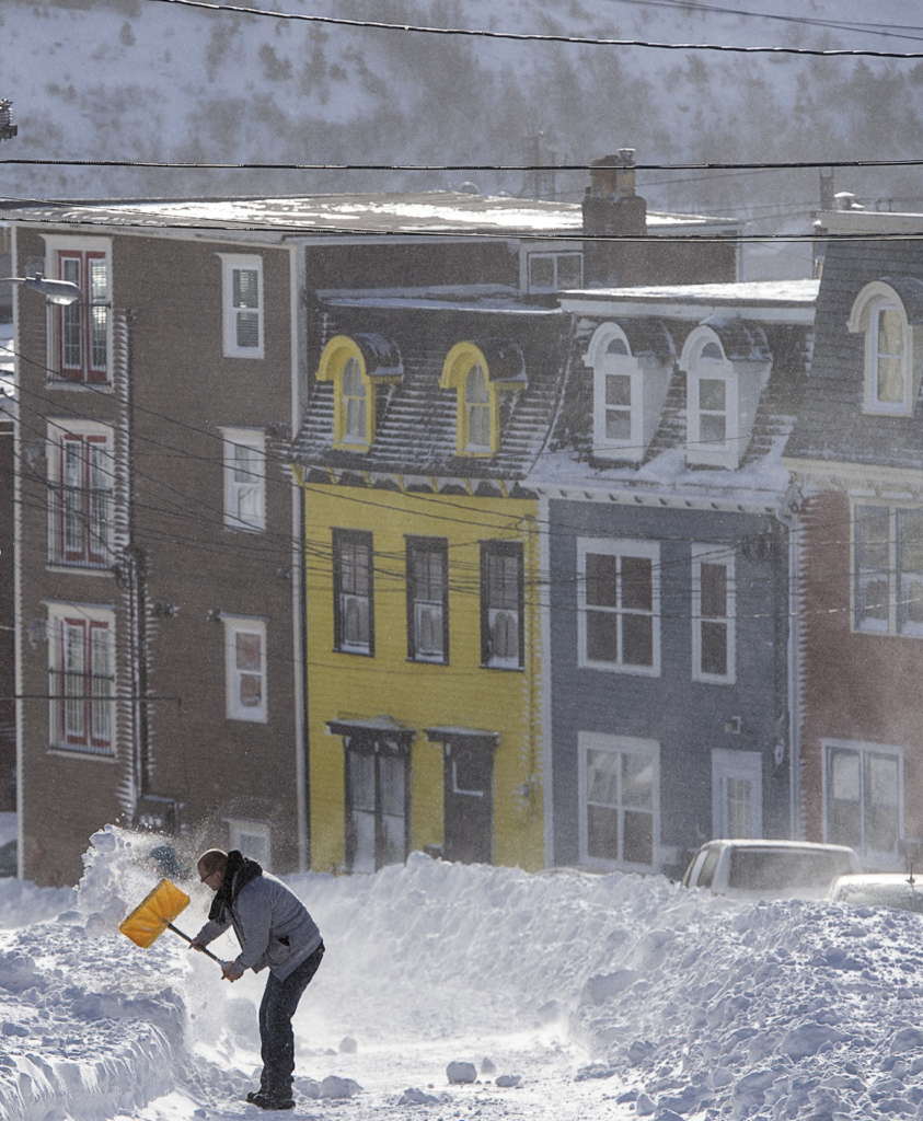
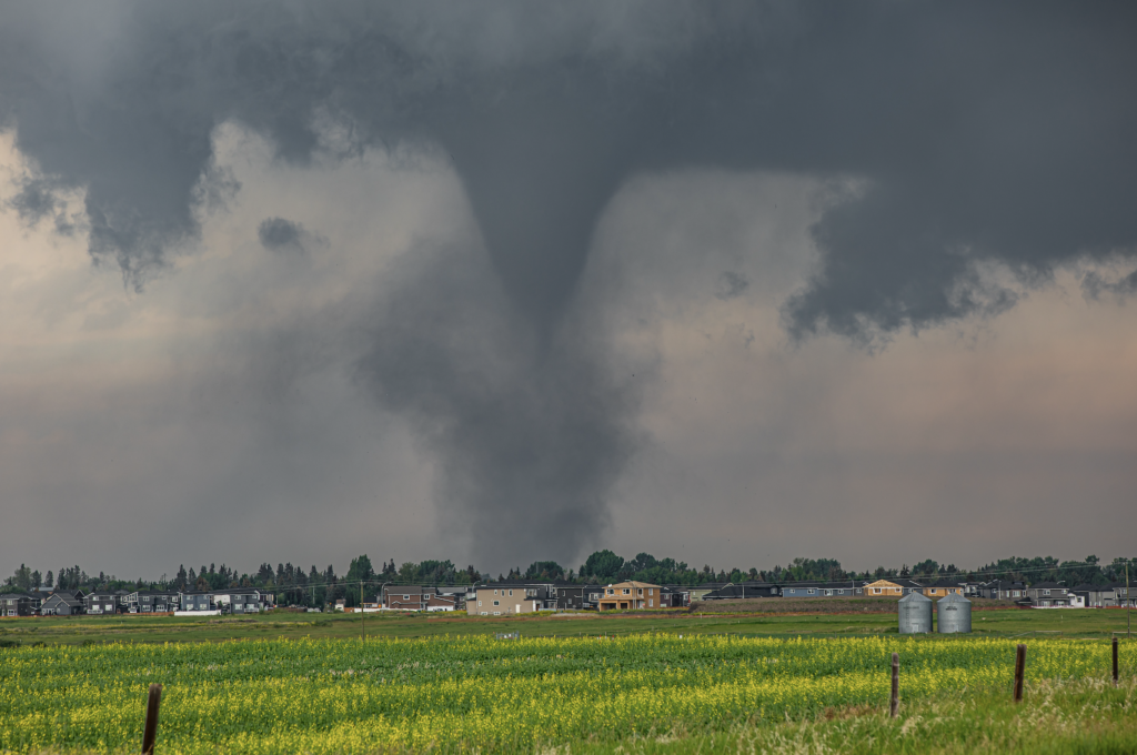
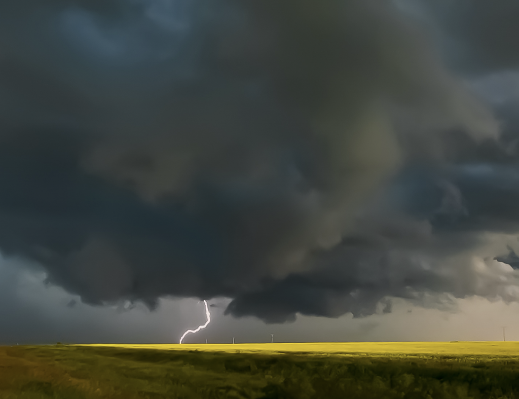
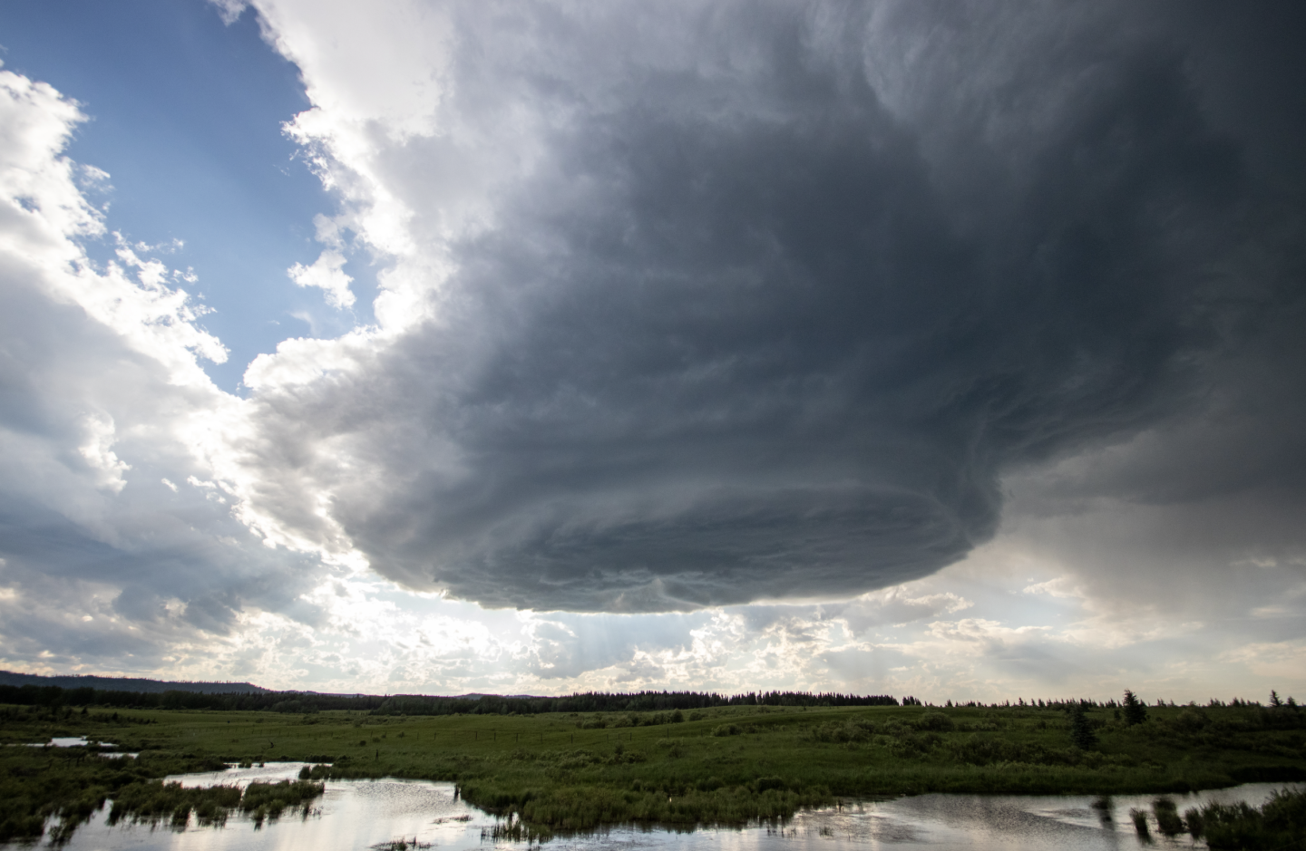
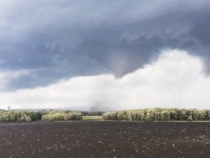
ONE OF THE MOST enduring stereotypes about Canadians is that we can’t stop talking about the weather — and for good reason. The sheer size of Canada’s land mass engenders the full spectrum of nature’s fury. Temperatures in many places can climb above 30 C in summer and fall to -20 C in winter. Hurricanes spin up the Atlantic coast, bringing rain, wind and scouring seas to the Maritimes and Newfoundland, and their effects can be felt as far inland as southern Ontario. For reasons not yet fully understood, atmospheric rivers can sometimes arrive one after another over a period of weeks, increasing the risk of flooding and landslides on the east and west coasts. Arctic air flowing over the warm Great Lakes at winter’s onset can generate jaw-dropping snowfall amounts and sudden blizzard conditions that routinely snarl traffic on some of the busiest roadways in the country. Tornadoes have been recorded in every province and territory but Nunavut.
So, the challenge facing Environment and Climate Change Canada’s meteorologists was to design an alert system that would be relevant and easy to understand no matter what type of severe weather is unfolding on any given day somewhere in the country. “Extreme cold” has a different definition in Iqaluit than it does in Toronto. Wagar hopes basing alerts on expected impacts instead of numerical criteria will help people better understand the risks associated with certain types of weather — and prepare accordingly. “We really want to be able to empower people to make those decisions to protect themselves.”
The other important factor in determining the level for an alert is confidence: how sure are Environment and Climate Change Canada’s forecasters that the weather is going to do what they think it’s going to do? In order for an orange or red alert to be issued, forecasters must be very confident that the event is going to have significant impacts. Wagar says today’s weather and climate models — computer simulations of the movements of the atmosphere used to predict the weather — are leagues beyond what they were even 15 years ago in terms of accuracy and precision. “We can tell you temperature trends several months out. We can see a big snowstorm coming next week. Is it going to be 10 centimetres or 20? As we get closer to the day, we can get more and more precise.”
A major advantage of the tiered system is that it gives meteorologists the flexibility to change an alert when new information becomes available as a result of on-the-ground observations. Wagar gives the example of a cold alert for Norman Wells, N.W.T. that was upgraded from yellow to orange when local authorities reported water pipes were freezing a few days into a prolonged period of temperatures in the low minus 40s in January. “There’s a lot of collaboration that goes on behind the scenes … to get an understanding of what the particular vulnerability of an area might be,” she says. “If there’s a widespread power outage going on and there’s a massive cold wave coming through, your vulnerability is higher, so that’s a big piece of that impact assessment.”
Once forecasters have determined an alert is needed, and the appropriate level for that alert, the next crucial step is to communicate it to the public. That’s where broadcasters like Kelsey McEwen come in. McEwen is the chief meteorologist for CTV Your Morning, where she delivers the daily forecast to a national audience and often breaks down unfolding severe weather events. Deciding what to focus on usually comes down to who is getting the worst weather — but “worst,” she’s learned, is relative.
“I was really excited for my first hurricane,” she recalls with a laugh. “I was like, ‘Oh, it’s gonna be a big one!’ And then we interviewed someone in the region who was like, ‘It’s just a little windy.’ That was a great lesson for me as a forecaster in Ontario that I needed to be in tune with what was out of the norm for [the east coast].”
For McEwen, one of the biggest positives of the new alerting system is that it takes into account the context in which the weather is happening. “There have been times through my career where it’s felt a little siloed, where you think ‘well, 10 centimetres of snow … is not that big of a deal.’” But now, if that snow is falling after 30 centimetres of snow on the previous day, a yellow-level event could be escalated to orange. And that is a big deal.
One thing that hasn’t changed from the previous system is that alerts can still take the form of a watch or a warning — a consistent point of confusion for McEwen’s viewers, especially during thunderstorm season. Watches indicate that conditions are favourable for severe weather to develop and are issued hours in advance. Warnings mean a storm is happening and will impact the warned area within 30 to 60 minutes. A favourite metaphor McEwen uses to explain the difference is meal preparation: “a watch [means] all the ingredients for dinner are on the counter; a warning means you’re about to take your first bite.”
According to Dave Sills, deputy director of the Canadian Severe Storms Laboratory at Western University in London, Ont., the purpose of a watch is to get people thinking about the possibility of an impactful storm before it’s upon them. “There are things you can do during that time [to prepare] that you wouldn’t be able to do later,” he says, such as securing loose items around your property that can become airborne during strong winds or making sure your family knows where to take shelter in the event that watch becomes a warning.
Under the new system, all tornado warnings will automatically be red level alerts. Sills, who also heads up the Northern Tornadoes Project, a major research initiative to improve the detection and prediction of tornadoes in Canada, is curious to see how the public will respond to that. Many people he’s talked to say the colour coding is intuitive, but he points out that when an orange blizzard warning was issued for London and other communities along the shore of Lake Huron in early February strongly advising people to stay off the roads, police still responded to dozens of collisions on the region’s highways. “You couldn’t make it any more clear that this is not a time to travel, so people also have to take up the message that is in these [alerts],” says Sills. “If you read that there’s going to be this risk of dangerous weather and you still are going out in it, there’s not much Environment and Climate Change Canada can do about that.”
McEwen agrees and says she’ll keep hammering home the difference between watches and warnings, even if it feels repetitive. “The difference between those two qualifications could mean the difference between somebody making a plan to go outside or cancelling. So I’ll say it over and over again if it means [keeping] somebody safe.”
One of the biggest positives of the new alerting system is that it takes into account the context in which the weather is happening.
IN THE END, it would be two weeks before Roste and her husband were able to get home to B.C. They hunkered down with friends in Calgary, feeling grateful as the days passed that they were safe and that their home was unscathed. But the news was grim. Flooding forced more than 17,000 people from their homes. On the fourth day of the storm, the Nooksack River in neighbouring Washington State overflowed, inundating the Sumas Prairie region of Abbotsford in several feet of water and killing thousands of farm animals. Mountain rivers became raging torrents, sweeping away bridges. Grocery store shelves were bare and gas rationing went into effect throughout southwestern B.C. as critical supplies couldn’t get through on the province’s broken highways.
Finally driving into Abbotsford on Highway 1 and seeing water all around was “surreal,” Roste says. The experience has changed how she understands and acts on weather alerts.
“When we hear an atmospheric river is coming again, you get nervous,” she says. “Now we take it seriously and we’ve paid a lot more attention to making sure the land around our home is tended properly.”
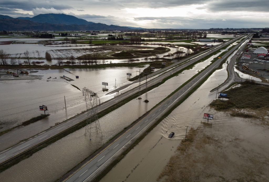
In late 2025, another strong atmospheric river dumped close to 100 millimetres of rain on parts of the flooding-prone Fraser Valley. This time, Environment and Climate Change Canada issued an orange rainfall warning for the valley and other areas extending inland. The B.C. River Forecast Centre responded with its own flood watches for the tributaries of the lower Fraser River, and the provincial transport ministry pre-emptively closed a stretch of Highway 1 between Hope and Lytton due to the risk of landslides.
“That was a great example of being able to upgrade [our warnings] to indicate the higher level of risk,” says Sekhon.
As of press time, no red alerts of any kind have yet been issued under the new system. There’s no telling when the first one will be needed and why. But when it is, hopefully we’ll be ready.
This story was created in partnership with Environment and Climate Change Canada.
This story is from the May/June 2026 Issue
Environment
Tracking the country’s extreme weather events to answer the question: are storms getting worse?

Science & Tech
Alberta-based computer scientist Mark Simpson can design anything he puts his mind to. So why has he chosen to chase tornadoes?
Science & Tech
Physical distancing requirements to slow the spread of COVID-19 will make it difficult for researchers to visit suspected tornado sites this year, so the team behind the Northern Tornadoes Project is calling on the public to help

Environment
Program used community reports and remote sensing to confirm tornadoes