Mapping
Best Canadian Geographic maps from 2015
If you’ve ever had to help make a map, it gives you a whole new appreciation for the art form. As editor of Canadian Geographic, I’ve found myself more…
- 899 words
- 4 minutes
Mapping

“I wisely started with a map, and made the story fit.” So once famously said author J.R.R. Tolkien of Lord of the Rings fame. I was reminded of his position on the importance of cartography in storytelling while I was doing research for “Map quest,” a feature exploring the amazing mapping connections in video games that I wrote for the July/August 2019 issue of Canadian Geographic. Personal bias aside, I’ve included the map our cartographer — the unrivaled Chris Brackley — created to accompany that story below along with five other standout pieces Brackley and my colleagues at Can Geo helped make this past year to highlight some of the best of our cartographic creations from 2019. This is our fifth annual such roundup (see 2018, 2017, 2016 and 2015, too). I hope your inner map geek enjoys scrolling through these as much as I did collecting them!

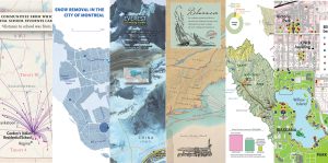
This colourful map accompanied a feature story by Leslie Anthony on the slow disappearance of permafrost in Canada and how it is influencing global warming in communities and habitats in Canada’s North and around the world. The inset map depicts the permafrost types or zones in Canada, while the main map indicates the concentrations of organic carbon in surface layers of permafrost. As it thaws, this carbon is released in the form of greenhouse gas emissions, which contributes to the effects of climate change.

This chart of Canada’s Far North marine environment combines a number of data sets — from shipping types and hydrocarbon potential to commercial fisheries and marine mammal concentration areas — included in Canada’s Arctic Marine Atlas, which was produced by conservation group Oceans North in partnership with World Wildlife Fund Canada and Ducks Unlimited Canada. The result of this compilation is a dizzying, yet impactful, snapshot of areas where human and animal habitat use overlap.

In conjunction with the 60th anniversary of the St. Lawrence Seaway, we created this map that shows, amongst other things, the total volume of cargo shipped through the seaway by port, both imported and exported. What emerges is a quick glimpse at the economic importance of this critical continental transportation route and the cities along it that see the most activity.

The map on the left is the one I mentioned above from my feature story on the importance of mapping in video games. In and of itself, there’s nothing special about it — indeed, it’s simply a real-life map of the Aegean Sea region. But it’s critical in appreciating the lengths the designers of the video game Assassin’s Creed Odyssey went to in accurately recreating the area for the historical fiction. It was designed to mimic the real world from “a bird’s eye perspective, from the unmistakable hand-shape of the Peloponnese to the cover of Salamis to the peninsula of Attica to the trident of Macedonia,” as the game’s world director Benjamin Hall told me. And it does. Of course, a key difference? Urban areas (pink on the maps) appear much larger in the game than in reality — a conceit necessary for the game-playing experience. Bonus: check out this great video of Hall explaining the game’s cartographic process.

The beauty of this piece, which appeared as the “On the map” department in our November/December 2019 issue, is in its simplicity. We asked Brackley to show the nation’s largest lakes entirely within Canada’s borders at relative size and the result is both visually and thoughtfully artistic. I could go on at length about all the layers of intrigue I see in it, but that feels like it goes against the basic approach behind this “map.”

As much graphic as map, this creation accompanied a feature story by Canadian Geographic contributing editor Alanna Mitchell on the latest research on the health of the world’s oceans — 10 years after the release of her seminal book Sea Sick: The Global Ocean in Crisis. Brackley was keen to make a map that showed the critical interplay and impact of greenhouse gas emissions on the Southern Ocean, its globally dominating circumpolar current, the troposphere and the stratosphere. Mission accomplished. This piece encapsulates in a nutshell how climate change-induced impacts on the Southern Ocean are worsening planet-wide ocean health and negatively affecting other key Earth systems.
Are you passionate about Canadian geography?
You can support Canadian Geographic in 3 ways:
Mapping
If you’ve ever had to help make a map, it gives you a whole new appreciation for the art form. As editor of Canadian Geographic, I’ve found myself more…

Mapping
Maps have long played a critical role in video games, whether as the main user interface, a reference guide, or both. As games become more sophisticated, so too does the cartography that underpins them.

Kids
Canadian Geographic Education’s series of giant floor maps gives students a colossal dose of cartography and is a powerful teaching tool
Mapping
Cartographic highlights from Canadian Geographic’s 2021 issues