Travel

The thrill of the hike: Exploring Bic National Park

Shaped by the sea, Bic boasts more than 25 kilometres of marked trails taking visitors over the water, through the forest and into the clouds

  • Oct 19, 2022
  • 944 words
  • 4 minutes
Bic National Park showcases the beautiful natural features and exceptional flora that make up this picturesque area. (Photo: Madigan Cotterill/Can Geo)
Expand Image

Open from sunrise to sunset, Bic National Park proudly showcases an array of changing landscapes, from islands and mountains to capes and coves. And with more than a dozen hiking trails to choose from, you can be sure to find a slice of nature that will put your busy mind at ease. But when it comes to specific routes, time is often of the essence, bringing a level of thrill to an already challenging adventure.

One of Quebec’s most underrated parks, Bic is a coastal paradise that offers wildlife watching, guided kayaking tours and trails. Located on the south shore of the St. Lawrence River, Bic covers 33 square kilometres and is best known for its large populations of harbour and grey seals and jaw-dropping views. You may want to linger, but if you choose one of Bic’s more challenging hikes, best not to dawdle.

Le Grand Tour takes visitors along Bic’s rugged coastline, which is only accessible during certain times of the day, depending on the tides. The trail may only be a 5.5-mile loop, but with its steep portions and rocky terrain, it can take more than three hours.

Bic National Park is known for its capes, bays and islands surrounded by the St. Lawrence River. (Photo: Madigan Cotterill/Can Geo)
Expand Image
Many of the trails throughout Bic will take hikers along rocky beaches with perfect views of the river. (Photo: Madigan Cotterill/Can Geo)
Expand Image

Le Grand Tour begins at the visitor centre. Follow Le Chemin du Nord, a four-kilometre trail along the coast that showcases small chalets presenting historical evidence of human occupation; this is also where you come to one of the first coves, a wide-open rocky beach with expansive views of the St. Lawrence river. And if you’re lucky, you might see sunbathing seals during low tide.

After a half hour of walking along this trail bounded by wildflowers and birch trees, the path deviates onto the beach for the first views of Bic’s rocky coastline. A sign has information on the tides and the appropriate times needed to complete this trail. The visitor guide suggests heading out two hours before the scheduled time of the lowest tide. The guide also recommends that hikers bring a first aid kit, gloves and proper hiking shoes while also being in good physical condition.

It’s easy to make a first rookie mistake and underestimate the difficulty of this trail — the  rocks will be slippery and potentially dangerous to walk on if you end up having to attempt the hike when the tide has risen.

At the end of Le Chemin du Nord, the trail begins on the rocks where no signage indicates you are going the right way. But don’t worry; just stick to the coastline. This is where the trail gets challenging. It is also where your hike may end if your timing is off with the tides. Several kilometres of Le Grand Tour is entirely underwater during high tide, rendering the trail inaccessible for 12 hours of the day. But if you’ve planned accordingly and are up for the challenge, this is where the views become even more impressive — just don’t enjoy them for too long.

The section of the trail known as Le Cap-à-L’Orignal is the most difficult, often entailing a four-limb scramble. The visitor guide describes it as “steep, dizzying and dangerous.” Rocks are often slippery from fog, rain or waves. With no set path to follow, it can also be tricky to figure out an exact route. Go too close to the water and you’re at risk of slipping on the seaweed-covered boulders, but climbing over the jagged rocks risks falls. Use your judgment to select a “comfortable” route.

Once the most challenging portion of the hike is completed, the trail opens up onto an open beach - the perfect place to take a quick break. (Photo: Madigan Cotterill/Can Geo)
Expand Image

After clinging to the coastline for several kilometres, the trail transitions into Le Grand Tour before diverging back into the forest. Some portions of this trail are along another expansive beach, Anse à Moulle-Cul. This section of the trail will bring complete satisfaction if you appreciate the smell of salty air, cool winds and being immersed in nature. The looming threat of encroaching tides has passed, and from here on out, you can enjoy a more typical hike. Just keep your eye out for the signage indicating the transition of the trail into the woods; otherwise, you will be stuck walking around the perimeter of the peninsula for several kilometres.

In the woods, the sound of crashing waves subsides and peace reigns, with a shady walk through a pine-dominated forest. Continue for about two kilometres until you reach a sign indicating that you have reached Le Scoggan, a seven-kilometre trail through the woods. Keep your eyes out for deer, foxes and the occasional porcupine.

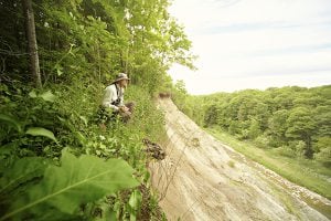
If you are not too tired, there is an option to deviate from Le Scoggan to Le Parcours La Pinède, a 5.8-kilometre trail through century-old jackpines to two magnificent lookouts. This hike is predominantly uphill, but the view is definitely worth it. Unfortunately, La Pinède does not transition into another trail, so you must backtrack to Le Scoggan before continuing your hike.

The view from one of the lookout points along La Pinède. (Photo: Madigan Cotterill/Can Geo)
Expand Image
On foggier days, views of the St. Lawrence River may be obstructed but the scenery can still be enjoyed. (Photo: Madigan Cotterill/Can Geo)
Expand Image

Now that you have made it to the home stretch, the remaining few kilometres along Le Scoggan can be enjoyed in peace as few people venture to this part of the woods. Named after renowned botanist Homer J. Scoggan, who inventoried the flora and fauna of the park from 1930 to 1940, Le Scoggan takes you through the majestic Fourche à Louison landscape before circling back to the visitor centre.

The hike, which takes approximately three hours is strenuous and best for advanced hikers and individuals confident in their outdoor capabilities. For families and less experienced hikers, there are more than a dozen other easy to intermediate hikes to choose from.

Other park activities include kayaking, geocaching, snow tubing and backcountry skiing. There are also more than 15 kilometres of bike trails.

Advertisement

Are you passionate about Canadian geography?

You can support Canadian Geographic in 3 ways:

Related Content

A crowd of tourist swarm on a lakeside beach in Banff National Park

Places

Smother Nature: The struggle to protect Banff National Park

In Banff National Park, Alberta, as in protected areas across the country, managers find it difficult to balance the desire of people to experience wilderness with an imperative to conserve it

  • 3507 words
  • 15 minutes
Andy McKinnon

Places

Canada’s first national urban park

It’s an ambitious plan: take the traditional Parks Canada wilderness concept and plunk it in the country’s largest city. But can Toronto’s Rouge National Urban Park help balance city life with wildlife?

  • 3601 words
  • 15 minutes

Places

National parks beginning to reopen across the country

Not all, but many of Canada's national parks will reopen to some extent on June 1

  • 438 words
  • 2 minutes

Environment

Green spaces crucial, but a challenge says 2020 Parks Report

The 2020 Canadian City Parks Report looks at challenges and opportunties for Canada's parks under a COVID-19 lens

  • 1415 words
  • 6 minutes