Mapping

RCGS releases new map in solidarity with Ukraine

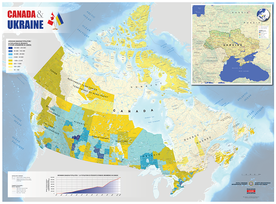
Map shows the distribution of people of Ukrainian descent across Canada, highlighting the deep connection between the two countries

  • Published Mar 25, 2022
  • Updated May 06
  • 770 words
  • 4 minutes
Choropleth map of Canada showing distribution of the Ukrainian-Canadian population across census divisions Expand Image
Advertisement
Advertisement

Over the past month, the world has watched in horror as Russia invades Ukraine in the largest military assault on a European state since the Second World War. And although the war is happening thousands of kilometres from Canada, for many Canadians it hits close to home, as this new map shows. 

Produced by the Royal Canadian Geographical Society as a gesture of solidarity with the people of Ukraine, the map shows the distribution across Canada of people of Ukrainian descent.

“The map is a reminder that Canadians have a stake in the survival of a free and democratic Ukraine,” says John Geiger, CEO of the RCGS. “For many of our citizens, it is deeply personal.” 

Some 1.4 million Canadians identify as being of Ukrainian descent — about four per cent of the country’s population. The data used to create this map came from the 2016 census; 2021 census results were not available at the time of publication. Each coloured area represents a census division, though Canadian Geographic cartographer Chris Brackley, who created the map, is quick to point out that the Ukrainian-Canadian population is not evenly distributed across each census division. For example, although census division 6 in Alberta encompasses Calgary and three surrounding counties, the largest share of the Ukrainian-Canadian population in that division resides in the city. The decision to use a choropleth map — where enumeration units like population density correspond to a particular shade or intensity of colour — was a stylistic one, allowing the colours of the Ukrainian flag to stand out visibly on the map of Canada. 

“Maps carry social meaning,” says Akaash Maharaj, a Governor of the RCGS and Ambassador-at-Large for the Global Organization of Parliamentarians Against Corruption (GOPAC). “For better or worse, how we choose to draw lines or representations of the world says something about the way we believe the world to be and the way we feel that the world ought to be.” 

Advertisement

It was Maharaj who initially suggested that the RCGS create a map to demonstrate that the Society and Canadians stand with Ukraine. Through his work with GOPAC, Maharaj witnessed firsthand Ukraine’s attempts to rebuild and strengthen its democratic institutions in the wake of the 2014 Maidan Revolution that ousted President Viktor Yanukovich.

“I think one of the reasons Ukrainians have been so astonishingly successful at holding back the invasion is because they are fighting for their home,” he says. “The fact that there are so many people in Canada for whom Canada is their home, but to whom home in Ukraine also calls, carries meaning.”

Another striking feature of the map is that Canada and Ukraine are shown at the same scale. The size of Ukraine in relation to Canada surprised Canadian Geographic Education Special Projects Editor Tanya Kirnishni, who was born in Ukraine and immigrated to Canada with her parents at the age of seven. 

Kirnishni has created a lesson plan for educators to use alongside the map, centering the immigrant experience and examining “push” and “pull” factors that might motivate someone to leave their country of origin and seek a new life elsewhere. The lesson plan was informed by her own family’s experience, she says. 

“When my parents graduated university, the future they had been planning no longer existed. The Soviet Union fell apart, and all their plans and expectations for the future became much more complicated.”

For Kirnishni, the opportunity to work on the map and lesson plan was a meaningful way to explore the connections between the country of her birth and the one she now calls home, and to show support for relatives and friends in Ukraine.

“I’m hoping Canadians will see this map as an example of one group of people that are just one thread in the tapestry of multiculturalism,” she says. “We are a nation of immigrants, and although we’ve come to call Canada home, I think that part of our hearts are still in other places.” 

A tiled, printable version of the map and the accompanying lesson plan are available for free download on the Canadian Geographic Education website. 

“Like most Canadians, we are horrified by this tragic war, while at the same time in awe of the bravery of the Ukrainian people fighting for their freedom and their country,” says Geiger. “We asked ourselves how we could help. Well, we are a geographical society, so we could produce a map, and we are an educational charity, so we could write lesson plans. Canadian individuals, organizations, and businesses all need to support Ukraine in any way they can.”

Expand Image

Are you passionate about Canadian geography?

You can support Canadian Geographic in 3 ways:

Related Content

Assassin's Creed Odyssey landscape

Mapping

Inside the intricate world of video game cartography

Maps have long played a critical role in video games, whether as the main user interface, a reference guide, or both. As games become more sophisticated, so too does the cartography that underpins them. 

  • 2569 words
  • 11 minutes

People & Culture

The symbolism of refugee ‘arrival kits’

The items given to Syrian refugees — warm clothing, DVDs, the Charter of Rights and Freedoms — represent more than just practical considerations; they're the building blocks of a shared Canadian identity

  • 1882 words
  • 8 minutes

Mapping

Creative Cartography: Matt Cusick’s map collages

This article is part of a series of Q&As with some of the best artists working with maps. Read…

  • 1186 words
  • 5 minutes
The War of 1812 giant floor encourages students to interact with history

Kids

Giant floor maps put students on the map

Canadian Geographic Education’s series of giant floor maps gives students a colossal dose of cartography and is a powerful teaching tool

  • 1487 words
  • 6 minutes
Advertisement
Advertisement