Travel
Go with the fleuve: 5 days in La Belle Province
Following the St. Lawrence’s winding course through Quebec delivers a feast of history, culture and food
- 2137 words
- 9 minutes
This article is over 5 years old and may contain outdated information.
Mapping

“I walk on unexplored ground every day,” explains Louis-Pascal Rousseau. He’s referring to the challenges of programming a unique mapping project, but —unintentionally — Rousseau is evoking the very core of his work: an interactive map that will let users walk through time and see Quebec City in ways no one has ever seen it before.
Touch History is still in development (watch the video below), but Rousseau, a postdoctoral researcher at the University of Pennsylvania, is hoping to get the website online in the next seven months. When it is finished, users will be able to use historic maps, photos and even paintings to explore the development of the oldest city in North America through six sieges and four centuries.
Several years ago, the Mannahatta Project, which mapped the pre-European ecology of what now forms New York City, aimed to remind the public that even the greatest cities are built on a natural setting. Now, Rousseau’s project will take that natural setting and overlay the city’s historical development to form a four-dimensional picture of Quebec City, street by street.
“I want to allow everybody in the city to visualize any place in the city in its historical context,” says Rousseau. “With the interface we are building, it will be possible to go back in time in such a way.”
Rousseau grew up in Quebec City, but one person’s knowledge can only go so far. So with only historical documents to rely on, Rousseau enlisted the help of locals to fill in some of the blanks. He started a Facebook page where he has benefited from a wealth of collective knowledge.
“When a group gets together and starts sharing their knowledge, you can get a lot of new information,” he says. “It’s a big part of the research.
Even with local help, superimposing imprecise historical maps on an exact modern satellite image has its challenges. Many of the maps Rousseau uses were hand-drawn, so the scale is less than perfect. But even the shape of the land itself has changed as the city has grown, pushing out into the St. Lawrence River.
“You have to stretch the old map, compress them, twist them, so that they fit the territory,” explains Rousseau.
War doesn’t help, either: parts of cities get fortified, demolished and rebuilt during conflicts, and a city like Quebec City has seen its share of conflict.
Rousseau hopes to eventually bring the application to other cities, where he believes he would get the same local leg-up as he has had in Quebec.
“I think that people have a special interest in their own history,” he says. “I think Canadians would be willing to play that game.”
Travel
Following the St. Lawrence’s winding course through Quebec delivers a feast of history, culture and food

Mapping
Maps have long played a critical role in video games, whether as the main user interface, a reference guide, or both. As games become more sophisticated, so too does the cartography that underpins them.
Mapping
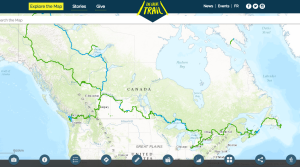
As Canada's most famous trail celebrates its near completion, Esri Canada president Alex Miller discusses the ambitious trail map that is helping Canadians get outdoors
Mapping
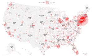
Canadian Geographic cartographer Chris Brackley continues his exploration of how the world is charting the COVID-19 pandemic, this time looking at how artistic choices inform our reactions to different maps