Travel
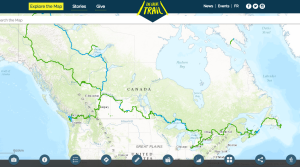
Trans Canada Trail celebrates 30 years of connecting Canadians
The trail started with a vision to link Canada coast to coast to coast. Now fully connected, it’s charting an ambitious course for the future.
- 1730 words
- 7 minutes
Travel
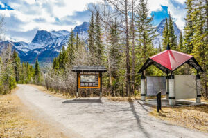
With its proximity to a number of small towns along the route, this Eastern Ontario trail is perfect for the seasoned walker looking for a not-too-rugged, wildlife-filled four-day hike
High grades for a level-grade, straight-ahead rail trail crossing three distinct Eastern Ontario ecological zones.
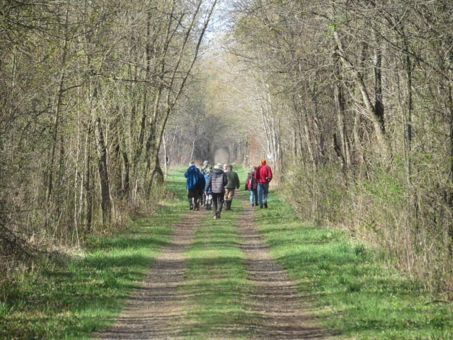
I made this trek in late April — no bugs! — so it wasn’t until Day 2 on Eastern Ontario’s Cataraqui Trail that I saw my first fellow walkers. It was the whimsically named Curd n’ Birding group, who had worked their way along the farm fence lines, looking for birds while edging ever closer to the Forfar Dairy Cheese Store.
Although they shared sightings of rufous-sided towhees, brown thrashers and meadowlark, alas, they had no curd to spare. Sigh. I could see the dairy just 600 metres across the field, but was unwilling to break momentum so early in the day, so on I walked dreaming of fresh, warm curd. And after another 10 kilometres, poutine.


On Day 1, I’d departed southwest out of Smiths Falls in a light rain and encountered not a soul during my 25-kilometre walk to the village of Portland on Big Rideau Lake. Plenty of wildlife, though: Deer, turkey, rabbits, turtles, snakes, birds of all feathers, and a particularly annoyed pair of swans that swam parallel to me through several hundred metres of their territory in the sprawling swamps below Otter Lake. A welcome feature of the trail is that it’s a level and graded rail bed, leaving plenty of time to look for wildlife and viewpoints, not your feet.
The Cataraqui Trail runs 104 kilometres from Smiths Falls to Strathcona (just northeast of Napanee), following a very well-maintained rail bed that alternates between fine gravel and packed-earth. The trail divides neatly into three distinct landscapes: the farm fields and lowland swamps from Smiths Falls to Highway 15 (not too far beyond Forfar); the highland swamps and rocky outcrops of the Canadian Shield, running from Highway 15 through Chaffey’s Lock to Sydenham; and the Limestone Plain that gradually descends from high escarpment just west of Sydenham down to the Napanee River valley at Strathcona.
I walked the trail in four days, in segments from Smith Falls to Portland (25 kilometres), Portland to Chaffey’s Lock on the Rideau Canal (18 kilometres), Chaffey’s to Sydenham (30 kilometres), and Sydenham to Strathcona (31 kilometres). It’s possible to line up Airbnb’s or bed and breakfasts in each village, but you can also camp at Chaffey’s Lock as long as you let the lockmaster know you are through-hiking the trail. It would also be possible to make stops and/or find accommodation at Otter Lake, or the lovely small towns of Harrowsmith, Yarker, Camden East and Newburgh. The longest stretch between trail access points is 15 kilometres from Chaffey’s Lock west to Maple Leaf Road.
The Cat is shared use, although predominantly a bike trail, with no motorized vehicles allowed in summer. Being on wheels would be very convenient for popping over to Forfar Dairy in Forfar village or Abrams Bakery in Newburgh, though!
Note that the trail starts at the edge of a small strip mall in Smith Falls and ends in back of a paper mill in Strathcona, but the 104-kilometre stretch in between is all rural bliss! As well, the Cataraqui Trail shares sections — or intersects with — the Trans Canada Trail, the Rideau Trail and the K&P Trail.
Travel
The trail started with a vision to link Canada coast to coast to coast. Now fully connected, it’s charting an ambitious course for the future.

Travel
An ancient Mi’gmaq migration route that follows the Nepisiguit River’s winding route to the salt waters of Chaleur Bay, the Nepisiguit Mi’gmaq Trail is now one of the world’s best adventure trails
Mapping
As Canada's most famous trail celebrates its near completion, Esri Canada president Alex Miller discusses the ambitious trail map that is helping Canadians get outdoors
Travel
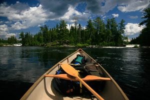
Inspired by age-old travelways, a new canoe route knits together the Trans Canada Trail