Environment
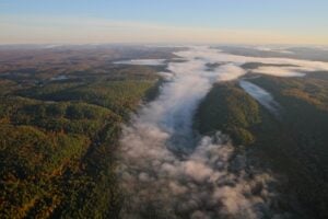
Preserving connectivity in the Laurentian Highlands
The new Plaisance-Tremblant (P2T) Connectivity Plan is preserving space for nature in a rapidly developing area between Ottawa and Montreal
- 1909 words
- 8 minutes
Mapping
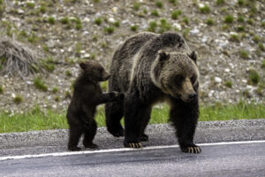
Connecting protected areas allows wildlife to roam, and is a vital part of the conservation conversation

When it comes to preserving biodiversity through the creation of protected areas of vital habitat, size matters. But so, too, does connectivity.
The reason is simple: all wildlife needs a lasting natural environment to thrive, but medium and larger mammals also need room to roam.
That’s why the international “30 by 30” initiative — which seeks to designate 30 per cent of the Earth’s land and ocean as protected areas by 2030 — completes only half the puzzle. Equally important is maintaining or creating wildlife corridors between protected areas to allow wildlife to travel from one protected area to another to find food, water, refuge and, critically, diverse mating opportunities to maintain healthy gene flow across the landscape.
A recent study — creating the first global map of where mammals are most likely to move between protected areas — shows that Canada is both a world leader in connectivity and home to many areas critical to animal movement.
“Previous studies have looked at the distance between protected areas, overall distribution of protected areas and how they are structurally connected,” says lead author Angela Brennan, research associate at the University of British Columbia’s Institute for Resources, Environment and Sustainability. “But nobody has looked at the connectivity of protected areas from the perspective of moving mammals. That’s called ‘functional connectivity.’”
Brennan and colleagues used an array of modelling and field data to rank countries by their functional connectivity between protected areas. Globally, they found the best- connected protected areas occur within the world’s two most intact biomes: boreal forest and tundra.
While that was expected, an important surprise was the countries — Canada in particular, which ranks third — where functional connectivity revealed greater linkages than in past research that simply measured physical connections. “We were able to account for all possible pathways between protected areas. That’s one reason Canada does a lot better,” says Brennan. “Large protected areas in the northern half of the country are surrounded by a lot of natural landscape with [relatively] low human pressures. So that means there’s a high degree of permeability and many different pathways for animals to move.”
Zeroing in locally, Canada has several spots that stand out as “critical connectivity areas” — zones where animal movement is both plentiful and concentrated. You can see these on the map. “They’re critical because if they’re lost, you’ll have a disproportionate effect on connectivity; you’re basically blocking connectivity by doing that,” Brennan says.
Brennan’s research found that more than two-thirds of critical connectivity areas globally are unprotected. This doesn’t necessarily mean the only solution is to create more protected areas, however. “We have options and opportunities to make sure that landscapes are managed to become more permeable to moving animals. These sorts of measures could be retaining natural habitats within agricultural areas, removing fences, building highway overpasses and underpasses — things like that.”
And Brennan has a message she wants all Canadians to take to heart: “People in Canada love their protected areas; they love to go and see wildlife and spend time in nature. I’d love to find a way for [them] to recognize the importance of connectivity to those experiences. Because if protected areas become isolated, those experiences will change. You have to have connected populations for ecosystems to thrive and for biodiversity to persist.”


This story is from the November/December 2022 Issue
Environment
The new Plaisance-Tremblant (P2T) Connectivity Plan is preserving space for nature in a rapidly developing area between Ottawa and Montreal
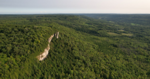
Environment
How the Escarpment Corridor Alliance is balancing the needs of wildlife and people in southern Georgian Bay
Environment
The ambitious B.C. non-profit is working with like-minded organizations to create a regional network of 12 protected corridors in the Kootenays

Wildlife
Jill Heinerth explores what can we learn from the lifecycle of freshwater mussels