People & Culture
2013 Innovation in Geography Teaching Award winner : Andrew Young
For an educator who has gone above and beyond their job description to further geographic literacy
- 533 words
- 3 minutes
This article is over 5 years old and may contain outdated information.
Environment
To fully understand our national identity, we must consider Canada’s geology as well as its geography

Harold Innis, an important early 20th-century Canadian intellectual, famously claimed that Canada “emerged not in spite of geography but because of it.” This assertion rested on Innis’s remarkable study of the fur trade in Canada. The statement was intended to emphasize that the country occupied a broad swath of territory — extending northward from the St. Lawrence-Great Lakes axis and the 49th parallel to wrap around Hudson Bay — where the fur trade had developed most fully. In this view, Confederation, and the transcontinental nation that followed, was the political reflection of a logic imposed by river systems (access routes) and the rock, forest and muskeg (beaver-friendly habitat) of the Canadian Shield.
There is something uncanny about Innis’s insight in the way that it floats easily between the mundane and the miraculous. It gives new significance to the inescapable fact that three of the five great North American drainage basins east of the Great Divide (which follows the crest of the Rocky Mountains) are almost entirely Canadian. It also makes obvious the not-entirely-self-evident conclusion that beaver from the boreal forests yielded heavier and better pelts than those from more southern climes. More than this, Innis’s claim did important political and nationalist work in its day. In particular, it suggested — in defiance of arguments that the country was a fragile political anomaly, doomed by its attempt to straddle the north-south grain of the continent — that the east-west nation rested on robust, natural foundations.

Innis’s provocative adage opened a new vista on the Canadian past, but it intrigued and tantalized rather than altered how historians wrote. Innis himself never fully explored its implications, although he had a more capacious view of the historian’s task than most of his contemporaries. His work on the fur trade was unusual in that it paid attention to the biological characteristics and life history of the beaver. Memorably, he pointed out that the beaver is an animal that “migrates very little and travels over land very slowly.”
But Innis was also a product of his times. His histories turned on the migration of Europeans to rich resource frontiers. They focused on the links between economic activity and political development, cultures and empires. He took the vast expanse of thin soil and exposed bedrock that encircled Hudson Bay — and the rivers that ran through it (upon which the fur trade was centred) — for granted. His book essentially ignored the eons of geological processes, climatic fluctuations and biophysical changes that had brought these features into existence. It paid scant attention to the particular characteristics of the north country and offered little detail about their influence on Canadian development. For Innis, as for others in the years between the world wars, everything had a past, but not everything was grist for the historian’s mill.
Today, rising anxieties about global climate change and other “environmental problems” have expanded horizons of concern, for both historians and the public at large. We are all now aware of the dynamic qualities of Earth systems and the complex reciprocal relationships that bind humans and nature together. So, it’s important to return to Innis’s assertion to rethink the bounds of Canadian history and develop a more expansive account of the past. Bringing history and geography together in this way means paying attention to the movements of mountains, the migrations of continents, the waxing and waning of deserts and swamps and the advances and retreats of glaciers, plants and animals. These processes open certain possibilities for human existence in some places and foreclose them in others. They create the (un)inhabitable Earth. In other words, humans live in material settings produced by physical processes — and their capacity to amend and transform their surroundings is, and always has been, highly variable. Everywhere, however, lands and lives are shaped by the reciprocal interplay of humans and their environments. This is the central insight of environmental history and a source of endless fascination.
In Canada, ancient and continuing physical processes underpinned the development of a nation across the vast expanse of northern North America. So we need to think anew about the “deep past,” which extends beyond the furthest reaches of human time, and the few millennia in which people have inhabited this ancient territory so recently named Canada. To look backward across this span is to contemplate a world in motion. Much of this movement was propelled by biogeophysical (or, broadly, Earth) processes. Sometimes they were infinitesimally slow, sometimes they occurred at rates discernible only over the course of a human lifetime and sometimes they were so rapid they were catastrophic. Humans came late to this place and story, and here and there, and with increasing potency, they added their agency to the forces of nature. Yet the very survival and prosperity of migrants to this world — which was at once old and new — rested on foundations laid down millennia before. At the same time, these people depended on their own resilience, ingenuity and perseverance to adapt to circumstances and utilize nature’s endowments.
Scientific and popular interpretations of the natural world have evolved through time, as have the words we use to describe it. This means that we need to pay attention to how knowledge is constructed. Only by doing so can we hope to understand nature’s role in shaping human lives, people’s individual and shared prospects and, ultimately, even intangible and elusive ideas such as nationhood. For example, the terms pre-Cambrian and Canadian Shield trip so easily from 21st-century tongues that it is easy to forget that both are recent coinages. The science of geology, to which these words “belong,” only emerged in the late 18th and early 19th centuries. Not until 1835 was the name Cambrian applied to the earliest known fossil-bearing strata (in Wales and now dated to between 541 and 485 million years ago). Earlier so-called primitive rocks then became pre-Cambrian by implication, but they were also known until 1900 as Azoic (or lifeless) rocks.
When British North American geologists claimed, in 1863, to have discovered a primitive fossil, christened Eozoo?n canadense, in ancient (metamorphosed) limestone from the Ottawa Valley, they believed they had made a revolutionary discovery that challenged the Azoic paradigm. But they located their find in so-called Laurentian rocks, a local nomenclature that was applied (as Laurentien) in 1845 by Franc?ois-Xavier Garneau, a French Canadian nationalist historian, to the mountains north of the St. Lawrence River. The term was subsequently conferred upon the larger Laurentian Plateau and the Laurentide Ice Sheet that covered it during the Pleistocene glaciation. The Canadian Shield only came into terminological being in the 1880s. Its name combines two ideas. The first was colonial politician Thomas D’Arcy McGee’s vision, articulated in 1860, of “one great nationality bound, like the shield of Achilles, by the blue rim of ocean” encompassing “the Western mountains and the crests of Eastern waves” as well as the rivers and valleys between. The second was the strong nationalist sentiment of influential Canadian imperialists in the quarter century after Confederation.
Comprising over half the area of present-day Canada, the eight million square kilometres of pre-Cambrian “shield” is the exposed portion of the ancient geological core of North America. Radiometric dating and other recent techniques have revealed that parts of it are four billion years old and that the whole is made up of various fragments of material, which erupted from hundreds of now-extinct volcanoes that coalesced and amalgamated between 2.45 and 1.24 billion years ago. But such a fine-grained understanding was beyond scientific reach until it became possible, in the latter part of the 20th century, to determine the age of rocks by calibrating decay in their radioactive elements.
Scholars were skeptical when the German scientist Alfred Wegener suggested, in 1912, that the continents were in motion. He came to this conclusion in an effort to account for the presence of warm-climate fossils in Arctic rocks and to explain why continental edges seemed to fit together like pieces in a puzzle (think of Brazil and West Africa). Despite the intuitive logic of Wegener’s idea, the notion of continental drift seemed largely fanciful until the 1950s. In that decade, studies of paleomagnetism (which reveal the intensity and orientation of Earth’s magnetic field locked into ancient rocks at the time of their formation) showed that the Indian subcontinent had once been in the southern hemisphere. Within a few years, scientists had refined the idea of continental drift (or wandering continents, to use South African geologist Alex du Toit’s felicitous 1937 phrase) into a theory of plate tectonics and had added a driving mechanism to explain the outwardly improbable. Simply put, the theory envisaged convection currents in the Earth’s mantle causing convergent and divergent movement of several plates comprising the Earth’s surface. Proceeding at between 250 to 1,500 millimetres a year, these movements are now understood to have caused the formation, breakup and migration of continents over time.
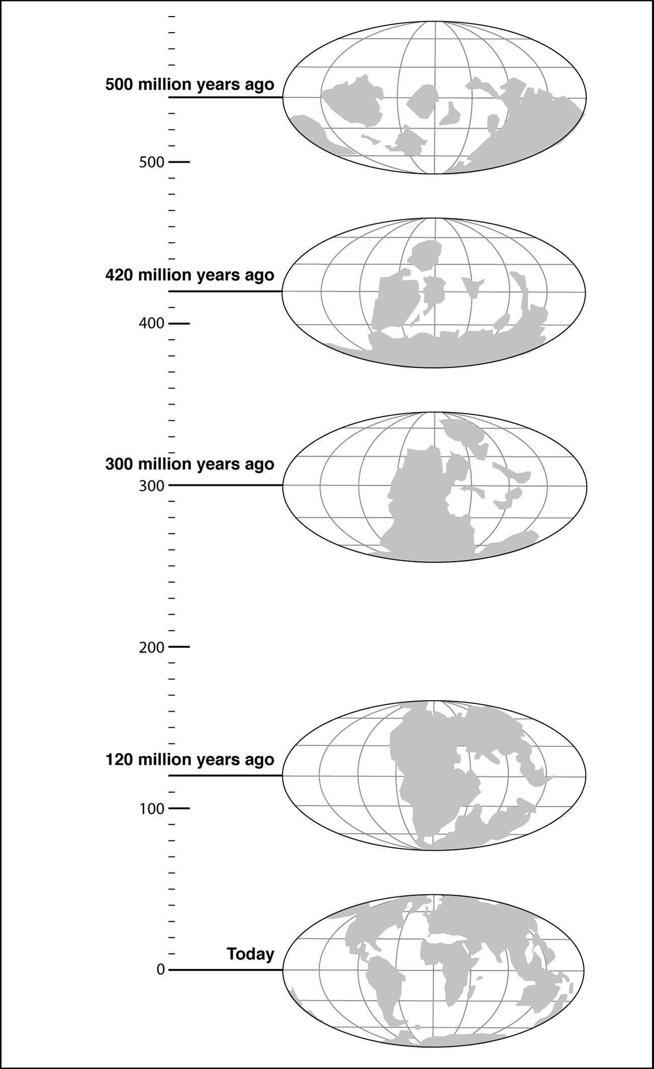
Through the millions of years of these movements, the shield formed the nucleus around which geological processes built the North American continent. It shaped the configuration of the continent, differentiated its topography and moulded its potential (or otherwise) for settlement and development by humans eons into the future. Two examples suffice to make the point. First, about two billion years ago, the Flin Flon greenstone belt of central Manitoba and east central Saskatchewan was formed by volcanic activity. Approximately 45 kilometres wide and five times as long, it is one of the richest mining areas on the globe. Since 1916, more than 20 mines have extracted copper, zinc and related metals from this area, and three others have produced gold and silver. Second, some 1.85 billion years ago, a giant meteorite struck the Nuna (or Columbia) supercontinent, from which later plate configurations evolved. The resulting crater, the second largest in the world, filled with magma that contained nickel, copper, platinum, gold, palladium, and other metals. Unsuspected and undetected until the decade before Confederation, these deposits made the Sudbury Basin of Ontario one of the world’s most productive mining areas. Early this century, it produced half of the $10 billion generated annually by mining in Ontario. It also accounted for an eighth of the $40 billion that the 370,000 Canadians directly employed in mining contributed to Canada’s GDP.
Through the ages, winds, rain, and ice eroded the shield’s soaring mountains (some of them thousands of metres higher than present-day Everest) down to a low plateau of rolling hills. Vast quantities of sediment were deposited, layer after layer, in the shallow waters surrounding the plateau. Over time, they formed sandstones and shales, interleaved with limestones formed in clearer waters. Today, the land between the shield and the St. Lawrence Valley produced by these processes (the country north of Belleville in present-day Ontario) is a region of bare limestone plains, thin soils, and abandoned farms. This, wrote poet Al Purdy in a memorable phrase that echoed the tribulations of those who had tried to settle there in the nineteenth century, was “the country of our defeat.”
Another vestige is the vast Western Canada Sedimentary Basin, the lower reaches of which are made up of limestone-dolomite rich in evaporite minerals, including potash. As the Laurasia (Laurentia and Eurasia) Plate, with the shield at its heart, traced its gradual course across the globe through tropical and subtropical latitudes during the Carboniferous and Cretaceous periods, lush vegetation flourished, died, and decomposed. It turned, eventually, into rich coal and oil and gas deposits in what we now call the Atlantic provinces, the central Plains, and British Columbia. At much the same time, an eastward-moving oceanic plate slid beneath the continental landmass off the Pacific Coast. New terranes or continental fragments were accreted to the western margin of the continent. These processes raised up the cordilleran mountains and produced a spate of tectonic activity that created important deposits of copper, lead, zinc, gold, silver, and other minerals.

Much of Canada’s modern development has turned on these ancient foundations. For all the importance that Innis attached to geography, Suzanne Zeller, a historian of science, argues that geology (as well as meteorology and botany) was crucial in bringing British North Americans to contemplate the idea of a transcontinental nation. In her view, the mid-19th-century geological surveys of William Logan were vital to the development of an ideology of nation building. In the wake of Britain’s industrialization, when coal was regarded as a prerequisite for industrial wealth and power, Logan’s report of a dearth of coal in central Canada and its abundance in Nova Scotia was a significant impetus to Confederation. It prompted those who lived by the Great Lakes to recognize a “community of interest” with those who dwelled by the sea. Similarly, the gold and other mineral rushes that brought remote locations in the North and the Cordillera into the world trade system, fired Canadian imaginations about the value of the great Northwest and promoted interest in these territories. Mines continue to generate billions of dollars for the Canadian economy. Oil and gas do the same. In 2013, Canada’s oil exports, about two-thirds of total domestic production, were valued at $75 billion. But the uneven distribution of these resources has shaped and sharpened political tensions within the country.
People & Culture
For an educator who has gone above and beyond their job description to further geographic literacy
Kids
Éveiller la curiosité des enfants pour la nature est bénéfique à leur bien-être et essentiel à la préservation des espaces naturels. Les guides Curieux de nature, une nouvelle ressource pour les enseignants et les parents, peuvent y aider.
People & Culture
Alex Trebek's involvement in the Canadian Geographic Challenge and International Geographic Olympiad inspired generations of young learners

Science & Tech
Canadian Geographic is following this history-making mission, which saw Canadian Space Agency astronaut Jeremy Hansen become the first Canadian to fly around the moon