
People & Culture
Geographers create action plan for geographic education in Canada
Despite Canada's silver win at the National Geographic World Championship in July,…
- 463 words
- 2 minutes
This article is over 5 years old and may contain outdated information.
History
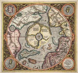
Defining where southern Canada ends and the North begins is trickier than it seems


Let’s say you live in Flin Flon, Man. Or maybe Fort Vermilion, Alta. Or maybe even Whitehorse, Yukon. Would it surprise you to learn that you don’t actually live in the North? Well, not according to Chuck McNiven and Henry Puderer, anyway.
Instead, you live in an area called “North transition,” one of four regions the Statistics Canada geographers created (the others being “North,” “South transition” and “South”) in an attempt to determine exactly where Canada’s North is.
“To solve this cartographic brain teaser,” Mary Vincent wrote in the September/October 2000 Canadian Geographic story that explained McNiven and Puderer’s work, the two men “defined ‘northness’ using 16 characteristics, such as how often you have to flick on the furnace; the limits of permafrost, boreal forest, railways and all-season roads; number of agricultural growing days; climate; and accessibility to urban centres.”
The conclusion Vincent draws might cheer those who live in the North but discourage North transitioners, to coin an appellation for residents of that region. “And in Canada, it seems, it’s better to be on top of the country than in the middle. The North has huge hydroelectric facilities in Labrador and Quebec, extensive mining and jobs in territorial capitals and is less reliant on government sources of personal income than is any other part of the country. The North transition zone, on the other hand, emerges as Canada’s hidden have-not region, an area with few resources or urban centres.”
People & Culture
Despite Canada's silver win at the National Geographic World Championship in July,…

Places
The 49th parallel forms a major part of Canada’s southern border with the United States. Test your geography smarts with our ultimate quiz!

People & Culture
Ontario students uphold Canada’s legacy of excellence at annual student competition held in Indonesia
People & Culture
In this essay, noted geologist and geophysicist Fred Roots explores the significance of the symbolic point at the top of the world. He submitted it to Canadian Geographic just before his death in October 2016 at age 93.