Exploration
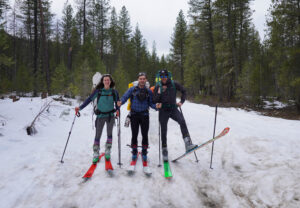
Tracking a 37-day expedition in the Monashee Mountains
Reflecting on an epic 600-kilometre ski traverse across the southeastern B.C. range and charting human and wildlife activity along the way
- 1591 words
- 7 minutes
This article is over 5 years old and may contain outdated information.
Science & Tech
As geotracking technology on our smartphones becomes ever more sophisticated, we’re just beginning to grasps its capabilities (and possible pitfalls)

At 11:39 p.m. on the night of December 30, 2015, about 51 kilometres below the surface of the Haro Strait between Vancouver Island and the San Juan Islands, the Juan de Fuca plate slipped. The response, in bedrooms up and down the coast of British Columbia’s mainland and island communities, was quintessentially modern: people reached for their phones. Within two minutes, the European-Mediterranean Seismological Centre, maker of the LastQuake app, was already receiving eyewitness reports. From Victoria, 18 kilometres from the epicentre: “Like something rolled through the house.” From Delta, 60 kilometres away: “Sudden, hard jerk, but short.” From New Westminster, 74 kilometres away: “We were awoken by rattling.”
In truth, the 1,422 comments received — a new record for LastQuake — were just gravy. Merely by opening the LastQuake app or surfing to its website, regardless of whether they filed an eyewitness description, users were sending a geolocated signal to the centre’s servers. When enough people in a given area open the app, the system automatically generates a map that pinpoints the approximate location of the suspected earthquake, typically within 20 to 90 seconds of the event — before the sophisticated network of seismic sensors installed around the world kicks in. “In 2015 in Vancouver,” says Marina Corradini, a seismologist at the centre’s headquarters outside Paris, “the launches of the app and the visits to the website were the first indications of the existence of this felt earthquake.”
If that feat doesn’t impress you, it may be because familiarity and ubiquity have made something truly magical — a tiny device that lives in your pocket or purse and always knows exactly where you are — seem normal. The first phone to incorporate Global Positioning System service, a model called the Esc! made by now-defunct Finnish company Benefon, was a relatively obscure niche product when it launched in 1999. But rapidly advancing technology, along with a decision in 2000 by U.S. president Bill Clinton to discontinue the longstanding policy of deliberately degrading the accuracy of GPS satellite signals for non-military users, helped the idea catch on. By 2009, a year after Apple added the feature to its second-generation iPhone 3G, 40 per cent of smartphone owners reported using their phones for turn-by-turn navigation.
The feeling, and perhaps even the very concept of being lost, is fading from our collective consciousness.
These days, about 90 per cent of Canadians have a smartphone (the figure is over 97 per cent for those under 45, according to Statistics Canada). We’ve quickly grown accustomed to neighbourhood-specific weather alerts, to real-time traffic guidance, and to being able to instantly pull up a list of moderately priced, kid-friendly restaurants within walking distance of wherever we happen to be. The feeling, and perhaps even the very concept of being lost, is fading from our collective consciousness.
And yet we’re just beginning to grasp the power and capabilities of universal geotracking. Our devices, and the services we use them to access, don’t just know where we are. They know where we’ve been, and where everyone else is and what people who go to the places we’ve been to are likely to do next. That awareness unlocks a whole different set of capabilities beyond simply knowing your coordinates. It also raises concerns about privacy and changes the way we interact with the spaces we inhabit. To understand what it all means, start with a turkey named Turk.
Today’s geolocation capabilities have far broader implications. They don’t just tell you where in the world you are; they help construct that world.
In the spring of 2019, a wild turkey escaped from an agricultural event at Calgary’s Stampede grounds. Pretty soon, sightings in the nearby neighbourhood of Ramsay, southeast of the city’s downtown core, began to show up on Facebook. A pilates instructor named Avery Maxwell set up a page called Loyal Followers of the Ramsay Turkey to keep track of his wanderings and to encourage people to give Turk — as he was soon dubbed — plenty of space and to avoid feeding him. It soon became clear that Turk intended to make the most of his freedom, with sightings popping up in neighbourhoods around the city as he crossed and recrossed both the Bow and Elbow rivers.
When COVID-19 shut down traffic, Turk had more space to roam, and people had more time to see him. The Facebook group soon grew to more than 6,000 members, and the resulting profusion of photos gave Lynn Moorman, a professor at Mount Royal University, an idea. Moorman, whose areas of instruction include geographic information systems (GIS) and geospatial innovation, had attended a workshop a few weeks earlier on a software tool called ArcGIS Survey123 that enables users to create simple forms or surveys tagged with precise location information. Over the course of a single weekend, she put her newly acquired skills to work and created an app called TurkTracker that let people report their sightings, automatically grabbing the geolocation data from their phones and feeding it into an interactive map and database.
For Moorman, a governor of the Royal Canadian Geographical Society, the goal of the exercise was partly educational, to give her students a real-life dataset that would allow them to play around with ways of visualizing geographic data — like plotting a heat map of sightings that conveyed Turk’s favourite haunts. It was also a way of engaging people in “citizen science” and raising awareness about geography — a rousing success, Moorman says, although Turk’s grassroots campaign for mayor was abruptly ended last July when he was eaten by a coyote. But perhaps the most remarkable thing of all was the timeline. That Moorman was able to throw together the app in a weekend, working alone and with no budget, shows that geotracking is no longer the exclusive domain of big tech companies. “It’s so accessible to the public now,” she says. “We’ve really democratized the geospatial tools.”

These days, Moorman teaches her undergraduate students how to build simple location-aware apps using off-the-shelf software called ArcGIS Collector — a far cry from her grad student days in the early 1990s, when her tools for fieldwork were topographic maps, a compass and a big, clunky altimeter. She spent months hiking up and down cliffs, measuring and remeasuring coordinates and elevations to determine ancient lake levels. Even a decade after that, in the early 2000s, the work and cost involved in something like TurkTracker would have been prohibitive, she says. You would have had to manually collect each GPS point, give it to an expert using expensive enterprise-level software to put each point into a geographic database, then produce and disseminate a map.
That’s more or less how geographers tried to map the extent of the flooding in Alberta during the summer of 2013. Moorman recalls a colleague in Canmore manually entering water levels using GPS points collected by people on mountain bikes, day after day. Moorman herself was in California, at a seminar on the latest digital mapping and geolocation tools, when the catastrophic floods struck. She realized that the new skills she was learning offered a much more efficient way of tracking the water levels. After each day’s sessions ended, she worked all through the night using what she’d learned that day to generate instant maps of the latest flood data in Calgary, then sent them back to her colleagues at Mount Royal University to disseminate to the public. “It felt very big, and you felt very helpless, and it was the one thing I could do,” Moorman recalls. “And that says something about the power of geography, right?”
“That says something about the power of geography, right?”
When William Rucklidge joined Google’s Street View team in 2010, the company was rolling out its third generation of omnidirectional GPS-linked cameras to dispatch to the streets, laneways and footpaths of the world. Rucklidge, a Toronto native who works as a software engineer at Google’s Mountain View, Calif., headquarters, faced the unenviable task of figuring out how to handle the firehose of data flowing in from the growing number of cameras gathering imagery. “They were literally getting pallets full of disk drives,” he recalls. The mission was to “take this enormous number of pixels and make sense of them — try to extract knowledge.”
The interactive panoramas that Rucklidge and his colleagues introduced helped transform maps from inert two-dimensional outlines into the immersive and interactive digital worlds that Lynn Moorman and her colleagues now study. In addition to photos, Google and its competitors began adding contextual information about the environment: what businesses are nearby, when they’re open, how well traffic is moving, and so on.
This last addition marked another important transition, because traffic updates aren’t that useful if your phone knows only your own location. In 2009, Google started crowdsourcing geolocation data from users of its Maps app, allowing it to provide realtime updates on traffic flow throughout major cities. By comparing current traffic data to its growing cache of previous traffic data, the app can also determine whether conditions are more or less busy than usual, and even forecast future conditions — whether, for example, you’re likely to get stuck half an hour up the road in a traffic jam that hasn’t even started yet.

The key feature that enables Google to reach into the past and peer into your future is called location history, a setting that you can toggle on and off in your Google account (it’s off by default, and even when switched on, it’s set to delete your data after 18 months). If you leave it on, you can look back at the places you’ve been and the routes you’ve travelled, or zero in to figure out exactly where you were on a given day. This is the data, anonymized then aggregated with everyone else’s, that Google uses to analyze traffic patterns and determine how busy stores and restaurants are. Location history data lets Google determine hour-by-hour busyness throughout the week. The lighthouse at Peggy’s Cove, for example, is busiest between 2 and 3 p.m. on Saturdays, and people usually spend between 25 and 60 minutes there. Live busy-ness data, a feature that was launched in 2016 and experienced a big bump in popularity between March and May of last year thanks to the pandemic, also tells you how busy a place is right now.
It all starts to sound a bit technoutopian: the more location-specific information you give away, the better the location-specific information you get in return, in a virtuous cycle that seemingly benefits everyone. Earthquake detection apps, for example, don’t just use your information to rapidly detect tremors; they can send alerts, tailored to your precise location, warning you of an inbound quake. The MyShake app, developed at the Berkeley Seismology Lab in California, uses the accelerometers in phones to detect shaking directly, rather than waiting for a user to open the app. A pilot warning system launched in California in 2019 uses MyShake to confirm a quake and issue an alert within three to 10 seconds, potentially giving people up to 20 seconds to duck and cover. (The headline in Berkeley rival Stanford’s student newspaper: “Berkeley Develops Earthquake Warning App, Giving Each California Resident Just Enough Time to Illegibly Scribble Will Onto Napkin.”) With about 2,000 users in Canada, MyShake doesn’t issue warnings here yet — though that may change in the future, says Jennifer Strauss, the app’s program manager. She notes that Canada is a seismically active country — especially around British Columbia.
It all starts to sound a bit technoutopian: the more location-specific information you give away, the better the location-specific information you get in return.
Aggregated geotracking data is also beginning to inform big decisions about urban planning, thanks to companies like StreetLight Data, which is headquartered in San Francisco but also has an office in Vancouver. StreetLight analyzes the “location data exhaust” from cell phones, explains Martin Morzynski, the company’s VP of marketing and product. In addition to geolocation data from GPS navigation, Street- Light harvests location signals from about 400 apps — shopping apps, weather apps, dating apps, and so on. That yields about 100 billion anonymized location records a month, which it plugs into a massive data-processing system that uses machine learning to figure out who’s going where in both urban and rural areas around the world. “To you and me, it would look like a whole bunch of dots that are moving around,” explains Morzynski, “but to StreetLight’s data engine, they look like trips.”
The resulting trips can then be broken down by mode of transport, distance, duration and speed. Thanks to the app data gleaned alongside the trip coordinates, the company can also make inferences about the race, income, family status and education of the people travelling on a given route and whether they’re travelling to work or for other purposes. Compared with traditional traffic-counting methods, like pneumatic tubes laid across roads, the picture that emerges is much more detailed and nuanced. That allowed StreetLight to, for example, analyze the effects of Vancouver’s Slow Streets pandemic initiative (the city designated 40 kilometres of “slow streets” in summer 2020, using traffic barriers and signs to open up routes for walking and cycling, so residents could exercise and walk, bike or roll to many local businesses). It used app data to determine who was affected by the street closures, where they came from and where they were going, and which nearby streets absorbed the resulting traffic. Toronto city planners also turned to StreetLight in 2017 to understand travel patterns around two major suburban hubs slated for redevelopment — Don Mills Crossing and Keele-Finch.
As with all technology, there is a tremendous amount of good that can be done. But it is always a Faustian bargain. What we get on one side is taken from the other.
Urban planners aren’t the only ones turning to StreetLight and its competitors, Morzynski notes. Uber used StreetLight’s data to model where helipads should be located for its planned Uber Air service in Los Angeles; Siemens used it to model where electric vehicle charging stations should go. Retailers decide where to site new stores, developers conduct traffic studies for new buildings, and hedge funds look at customer traffic before investing in a firm. Your “location data exhaust,” in other words, can be monetized.
“The most valuable piece of data any and all app developers and service providers wish for is location,” says James Boxall, a lecturer in Dalhousie University’s department of Earth and environmental sciences. “As with all technology, there is a tremendous amount of good that can be done. But it is always a Faustian bargain. What we get on one side is taken from the other.”
The TurkTracker app that Lynn Moorman built was fully capable of displaying all the Turk sightings in real time — but she chose to deliberately delay the updates by a few days, to avoid spurring disruptive poultry-viewing chases by Turk’s fans. Even turkeys, it seems, need deliberate and thoughtful privacy protections once they’re being geotracked. StreetLight says it uses only data that has been stripped of personally identifiable details and presents only aggregated insights. Google adds random statistical “noise” to its location data that makes it slightly less accurate but more anonymous. Every app that tracks your location has to ask your specific permission to do so — though the full meaning of that consent isn’t necessarily clear. “If you’ve read the 95 pages of a Starbucks app licence,” Boxall says drily, “you’ll see they can use your location to ‘push notices’ or ‘use beacons’ to match your location and send you ads. That also means they can see where you are and who you are.”
For most people, location-sharing and privacy aren’t all-or-nothing propositions: the details of the implicit bargain matter.
A New York Times investigation in 2018, using anonymized app data of the type StreetLight relies on, was able to reverse engineer the identities of individuals from among the sea of “dots moving around.” “Your Apps Know Where You Were Last Night, and They’re Not Keeping It Secret” read the article’s inflammatory headline. One of those dots isolated by the Times turned out to belong to a 46-year-old math teacher named Lisa Magrin, whose dot travelled each day from a house in upstate New York to a school 22 kilometres away and then back again. The dots also traced a trail to her Weight Watchers meeting, her ex-boyfriend’s home and other potentially private destinations. “An app on the device gathered her location information, which was then sold without her knowledge. It recorded her whereabouts as often as every two seconds,” according to the article. It continued: “While Ms. Magrin’s identity was not disclosed in those records, the Times was able to easily connect her to that dot.”
The findings sparked another round of debates about privacy — but even Magrin, who used her phone to track her running routes, didn’t necessarily want to ditch geotracking entirely. For most people, location-sharing and privacy aren’t all-or-nothing propositions: the details of the implicit bargain matter.
That idea of a fair exchange is at the heart of an experiment Sarah Schmalbach ran in 2018 and 2019 with the Philadelphia Inquirer. Schmalbach leads the Local Lab at the Lenfest Institute for Journalism, a non-profit promoting innovation in journalism. Her focus is on local news, a struggling sector whose unique strategic advantage compared with national competitors is its focus on location. “These very tiny places — your block, the convenience store you go to, your grocery store, the restaurant you went to last week, the apartment you used to live in before you got married, where your parents took you on vacation in the summer — all these locations play a role in why local news matters,” she says.

The rise of personal geolocation, Schmalbach figured, presented an opportunity for local news organizations to deliver the right news at the right time to readers — based on knowledge, gleaned from cell phones, of where the readers were at any given moment in time. Ideas like this have been circulating for years, but it’s only recently that both geotracking technology and people’s comfort with sharing their location have come together to make it feasible, Schmalbach says. So, as a test, she and her colleagues set up an app called Here for Local Journalism and populated it mainly with stories from the Inquirer’s Pulitzer Prize-winning architecture critic Inga Saffron, along with other stories about real estate and public art that were strongly associated with specific locations in Philadelphia. If you’re wandering through downtown’s Love Park, for example, your phone might ping you about Saffron’s column exploring why the park’s $26-million renovation produced a disastrous “granite Sahara.”
The results were promising: the app’s location-based notifications received about four times more reader engagement than typical news alerts. And perhaps just as impressively, 98 per cent of users gave the app permission to access their location. “People trust Inga and her content,” says Schmalbach. They also trust local newsrooms to make a fair bargain that delivers value to the user: “We’re not trying to be extractive and just take location information,” she says.
The app’s request for permission to access location was designed to be as clear and succinct as possible. And in the end, it simply didn’t turn out to be a significant barrier. “You know how there’s that notion of what people say they care about, and then there’s what they actually care about?” Schmalbach muses. “I’m not saying they don’t care about who their location information is shared with, and to what end, and why. People definitely care about privacy. But I think they care about it more as a concept than the day-to-day ‘Where is my location information going?’”
Knowing where you are isn’t just about latitude and longitude.
In early February of last year, hunters snowmobiling home to the Arctic community of Cambridge Bay on Victoria Island in Nunavut noticed a fissure in the sea ice, six or seven metres across, stretching more than 15 kilometres across the mouth of the bay. The fissure cut directly across the usual winter route from the mainland back to Victoria Island, presenting a serious danger to anyone who didn’t expect it. “That’s a stretch of the trail that’s quite high speed,” says Angulalik Pedersen, a member of the search-and-rescue crew that scrambled to map the crack and flag out an alternate route. “You do a 10-kilometre straight run on the ocean where you’re picking up speed towing your load, and then all of the sudden you’ve got to make a 90-degree turn because there’s open water.”
Knowing where you are isn’t just about latitude and longitude. Back in 2009, I wrote an article about the neuroscience of navigation, and one of the people I spoke to was an anthropologist named Claudio Aporta, now at Dalhousie University, who along with colleague Eric Higgs had studied how the increasing use of GPS among the Inuit was changing their relationship with their environment. Back then, GPS units were mostly clunky singlepurpose devices, not the ubiquitous cell phones of today. Aporta told me about a 500-kilometre snowmobile trip he’d taken with an Inuk hunter during which they got fogged in. The hunter, who had been leading the way based on traditional cues like snowdrifts and wind directions, asked Aporta to guide them back to the main trail by following the GPS track he’d taken on the way out. “It was an incredible experience, because I could see absolutely nothing,” Aporta told me. “Believe me, I was sweating like crazy.” Luckily, they didn’t encounter any unexpected ice fissures — but the story illustrates what’s missing when all you’ve got is coordinates.
Among the Inuit, Aporta and Higgs wrote back in 2005, “the idea of being lost or unable to find one’s way is without basis in experience, language or understanding — that is, until recently.” More than a decade later, the adoption of navigation technology has only accelerated. A typical Arctic search-and-rescue crew, Pedersen says, will pack a cell phone, a satellite phone, a radio and perhaps a GPS-enabled tablet. The multiple layers of redundancy protect against issues like dead batteries and spotty satellite coverage. “Recently we’ve relied more on the technology,” he acknowledges. “But the other side of it is the traditional knowledge. All of our search-and-rescue crews have a lot of very experienced personnel that don’t need technology to go on the land. So that’s another level of redundancy.”
In the right hands, geotracking can be an amazingly powerful and positive technology.
News of the fissure that Pedersen and his colleagues flagged last year first spread through a Cambridge Bay Facebook page. But in December 2019, a new app called SIKU was launched with the goal of helping Inuit hunters and travellers share information about ice safety, wildlife sightings, weather and other topics of interest. Developed by a Nunavut-based charity called the Arctic Eider Society, the app relies on the geo-location capabilities of cell phones (which work even when hunters are far from cellular reception) so that photos or observations are automatically mapped and targeted alerts can be delivered. The app has been adopted by more than 6,000 users in 48 communities across the Arctic, with uses ranging from dangerous ice warnings to mapping the progress of the annual migration of geese across the Arctic. Privacy and trust, Pedersen notes, are built right in: “When you post anything on Facebook, it becomes Facebook’s data,” he says. “Whereas with SIKU, you are the knowledge holder.”
Geolocation, in other words, turns out to be valuable even — or perhaps especially — in the Arctic. Pedersen’s rescue missions are particularly straightforward if the missing party has a satellite beacon that sends their precise coordinates. But is there a cost for the convenience? If you no longer need to understand the subtle language of snowdrifts and water currents (or, farther south, if you no longer need to look at street signs and remember landmarks), does this change how you relate to the places around you?
“Something feels wrong about each of us inhabiting our own personal map rather than sharing something more universal.”
When I wrote about the rise of GPS back in 2009, I worried about losing my ability to find my way around my home city. But today’s geolocation capabilities have far broader implications. They don’t just tell you where in the world you are; they help construct that world. “The Google map on the phone in your pocket will show a kind of biased view of the world, tilted toward the things that it knows you are interested in based on your searches and also the businesses you’ve visited,” says Colin Ellard, a University of Waterloo psychology professor who studies how we navigate and how the spaces around us affect our brains and bodies. In a sense, it’s a physical manifestation of the idea of “filter bubbles,” the worrying social media trend in which clever algorithms present us with only the news and information we already agree with. “To me,” Ellard says, “something feels wrong about each of us inhabiting our own personal map rather than sharing something more universal.”
I share Ellard’s concerns but remain optimistic that, under the right circumstances, geotracking might also serve to better connect us with the physical environment around us. When the pandemic first shut down schools last spring, I downloaded an app called iNaturalist. The idea is simple: you snap a picture of a plant or animal, and the app uploads the location-coded image to a server that uses artificial intelligence to suggest possible identifications based on what it looks like, where you are and what similar species have been observed nearby. If the automatic identification doesn’t work, one of the app’s million- plus other users will likely chip in to help you nail down the ID.
Not every geotracking app delivers this sort of epiphany, and some take from us more than they give in return.
The data collected is used by scientists for things like tracking the spread of invasive species. But its primary purpose, the website notes, is simply “to connect people to nature.” The first time I went for a stroll with the app, on a trail along the Humber River near where I live in Toronto, I was surprised to discover a blackcurrant bush lurking in the woods. Its existence, a few blocks from where I grew up and have spent decades living, caught me by surprise. How many other edible plants lived nearby, I wondered. The short answer: a lot. We dined heartily on garlic mustard salads and pesto that spring, and as the season progressed, we ranged far and wide to harvest mulberries, mayapples, dewberries, wild grapes and other delicacies. Sometimes we found them ourselves and verified their identity with the app; other times we used the app’s search function to find new patches of, say, black raspberry.
Thanks to this app, whose very essence depends on knowing the exact location of all its users, I have a whole new sense of connection to the places around me. Scarcely a day now goes by that I’m not peering at a tree or bush in my neighbourhood and wondering, “Can I eat that?” Of course, not every geotracking app delivers this sort of epiphany, and some take from us more than they give in return. But iNaturalist serves as a reminder that, in the right hands, geotracking can be an amazingly powerful and positive technology.
Sarah Schmalbach, the locationbased news innovator, summarizes the dichotomy succinctly: “Anything can be used for good or bad, right? But we have to figure out when it’s good. And then do it.”
Exploration
Reflecting on an epic 600-kilometre ski traverse across the southeastern B.C. range and charting human and wildlife activity along the way
Environment
Another reckoning is coming with climate change. How do we deal with our mental health — and ultimately find hope?
Science & Tech
A sound artist listens for quiet in Grasslands National Park
Science & Tech
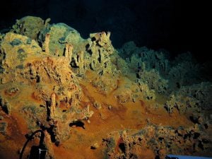
Researchers and industry leaders now have quicker access to data showing the complexity of the world’s seabed. Part five of Canada’s Ocean Supercluster: A six-part series.