
People & Culture
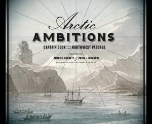
Excerpt from Captain Cook Rediscovered: Voyaging to the Icy Latitudes
Captain Cook Rediscovered: Voyaging to the Icy Latitudes seeks to provide a fresh view on Cook's legacy from a North American perspective.
- 1452 words
- 6 minutes
This article is over 5 years old and may contain outdated information.
Mapping
Canada’s Pacific coast took tangible shape after a visit from one of history’s most famous navigators


In an age when detailed maps of places halfway around the world are at your fingertips, it’s easy to forget that large parts of the globe were once a complete enigma.
In the late 18th century, one of those mysterious regions was the northwest coast of North America — that is until Captain James Cook arrived and, quite literally, put it on the map. The British navigator was on what would be his final voyage — a search for the Northwest Passage — when he sailed into Vancouver Island’s Nootka Sound in March 1778.
Cook wasn’t the first European to visit these waters — Spanish sailors had reconnoitered the area in 1774 and 1775, and when a mid-16th-century English shilling was unearthed on Vancouver Island last December, it added fuel to the theory that Sir Francis Drake voyaged to the region in 1579. But it was Cook who, in the words of the Canadian Institute of Geomatics, delineated the true shape of the northwest coast, ending the “imaginary cartography of the region.”
Cook and his crew spent a month in the sound, repairing their ships and, perhaps most notably, trading for furs with the Nootka people. They then sailed north and west, but were forced back by ice after passing through the Bering Strait.
Cook’s search for a route through the Arctic failed, but his exploration of the Pacific coast — and the subsequent tales of the treasures he found — helped bring to the West a flood of those hungry for the riches of the fur trade.
With files from Isabelle Charron, early cartographic archivist, Library and Archives Canada
People & Culture
Captain Cook Rediscovered: Voyaging to the Icy Latitudes seeks to provide a fresh view on Cook's legacy from a North American perspective.

Mapping
Maps have long played a critical role in video games, whether as the main user interface, a reference guide, or both. As games become more sophisticated, so too does the cartography that underpins them.
History
“There has been much myth making about Cook the man and Cook the navigator.”
Mapping
This article is part of a series of Q&As with some of the best artists working with maps. Read…