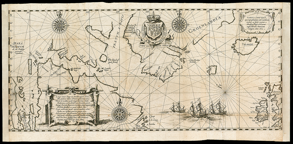
Maps can tell intriguing stories. But the tale of revolt and death behind this cartographic creation — the first to show Hudson Bay — is as fascinating as the map itself. The map might not have been published if it wasn’t for Abacuk Pricket, one of just eight mutinous crew members to return from explorer Henry Hudson’s ill-fated 1610 voyage aboard the Discovery to find the Northwest Passage.
After sailing through a strait and into a bay, both of which would eventually take his name, Hudson believed he’d found the Pacific — the Mare Magnum (Latin for “great sea”) seen on the map. He then steered south, a decision that by November would see the Discovery trapped in the ice of what is today known as James Bay (note the text on the bottom left corner of the map that reads “The bay wher Hudson did winter”).
By June 1611, the ice had melted and Hudson was ready to continue the search. Some crew members, however, were not, and the bitterness that had festered over the winter led to Hudson and eight others being set adrift in a small boat, never to be seen again. The remaining crew sailed back to England.
Pricket’s written account of these events caught the attention of Hessel Gerritsz, a Dutch cartographer and publisher. Gerritsz published this map, which is based on Hudson’s own cartographic work from the Discovery voyage, in Amsterdam in 1612.
Henry Hudson’s voyages
For a man who no one really knows much about, Henry Hudson certainly left a lasting legacy.
The English explorer’s name graces what is arguably Canada’s most famous bay, the strait that leads into it and, far to the south in New York, a vitally important river. Hudson travelled into these bodies of water (as well as several others on the other side of the Atlantic) during his four known voyages from 1607 to 1611, the year his mutinous crew set him and seven or eight others adrift during a search for the Northwest Passage. That journey would be Hudson’s last, and to this day his fate remains unknown. Listed below are details of Hudson’s first three voyages.
1607 The Muscovy Company of England employs Hudson to find a route to China via the North Pole. He captains the Hopewell to the east coast of Greenland before sailing as far north as the Svalbard archipelago. Ice blocks any further passage north, and the ship returns to England.
1608 Hudson sails for the Muscovy Company again, but this time in search of a Northeast Passage to Asia, via the Arctic waters off the coast of Russia. Hudson and his crew (which includes Robert Juet, who would play a role in the mutiny in 1611) take the Hopewell as far north and east as Novaya Zemlya, but are forced back again by ice-clogged waters.
1609 The Dutch East India Company hires Hudson to find a Northeast Passage. He sets sail for Russia’s northern coast once again, this time in the Half Moon. When ice blocks the ship’s passage, the crew refuses to go any farther. Acting outside his employer’s orders, Hudson turns around and heads to the New World, where he sails up what is now known as the Hudson River (which Italian explorer Giovanni da Verrazzano had discovered in 1524) as far as present-day Albany. His exploration would eventually lead to the Dutch colonizing the area.
To learn more, read about the inscription on Hudson’s map.