Places
Troubling signs of climate change are showing up on Nova Scotia’s remote Sable Island
Despite its isolation, tiny Sable Island is a microcosm of the broader environmental forces reshaping our world
- 779 words
- 4 minutes
This article is over 5 years old and may contain outdated information.
Travel
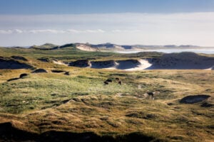
New drone footage showcases the spectacular beauty of this wild sandbar in the North Atlantic

About 200 kilometres off the coast of Nova Scotia lies a wild island that few people besides shipwrecked sailors, researchers and a handful of tourists have ever seen.
A wind-carved crescent of white sand dunes topped with marram grass, Sable Island is actually the visible part of a vast submarine sandbar that has claimed some 350 ships since the 16th century. Although it appears barren, the island is actually home to a unique and delicate ecosystem that includes the only known breeding ground of the Ipswich sparrow and, famously, about 500 feral horses believed to be descended from horses confiscated from Acadians during their expulsion from New France in 1755.

Its remoteness and frequent appearance in seafaring tales of the North Atlantic have caused Sable Island to be added to many travellers’ bucket lists, but tourism to the island is tightly controlled by Parks Canada to protect its fragile biodiversity. Those who do get to visit usually only get to do so for a few hours, which makes Gary Brinton’s experience all the more special.
Last summer, the Halifax-based photographer was invited to spend seven days on the island as a guest of Parks Canada, shooting drone footage that would help the federal agency showcase the island’s beauty and ecological significance. Over the course of the week, Brinton photographed sunsets, rain squalls, horses grazing, grey seals lazing, and even some crystal-clear night skies — rare for the usually fog-bound island. He notes that he was accompanied by a Parks guide at all times and followed a long list of rules to ensure the environment and animals were not disturbed as he worked.
“I wanted to capture what Sable Island’s beauty really looked like, but I also wanted to bring awareness to the importance of keeping the impact on this place to a minimum,” he says. “As much as people would love to visit this eighth wonder of the world, it’s important to realize that this is a very sensitive ecological landscape, with very unique characteristics found nowhere else on earth.”

Watch a supercut of Brinton’s spectacular footage below and be sure to follow him on Instagram to see more of his work.
Places
Despite its isolation, tiny Sable Island is a microcosm of the broader environmental forces reshaping our world

Places
The majority of bird species sighted on the Atlantic island are “vagrants” far outside their ordinary range

People & Culture
From a solo ski and mountain-climbing expedition to the South Pole to a project that mapped portions of Devon Island’s coasts for the first time, see what just a few of the RCGS’s Fellows have been working on in late 2018

Science & Tech
The students’ device will compete at an international innovation competition June 18 to 20