
Exploration
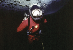
King of chill: Diving in the Arctic with the future King Charles III
Remembering a 1975 journey under the ice of the Northwest Passage with King Charles III
- 2808 words
- 12 minutes
Places
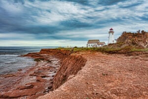
Remembering P.E.I’s iconic natural wonder after being washed away by Hurricane Fiona in the fall of 2022

Teacup Rock dies as it lived: dramatically. The formation stood alone, a stark, top-heavy mass of jagged, rust-red rock balancing delicately on a narrow and crumbling base. It looked impossible, defying the elements, the Atlantic and the laws of physics. Everyone knew it was on borrowed time, assuming winter ice pushing in from the Gulf of St. Lawrence would eventually topple the structure. In the end, it was the 140-kilometre winds and punishing waves of Hurricane Fiona that brought “the Teacup” down and washed it away.
“Every winter I would go check on it,” says Stephanie McQuaid, a part-time photographer and content creator who shares her work on Instagram under the handle @TheRedheadRoamer. “The road isn’t always plowed, so I’d snowshoe in to see it. The Teacup was always there.”
The rock, just off P.E.I.’s Thunder Cove Beach, was more than just the focus of many of McQuaid’s photos; it was her favourite place on Earth — so much so, she has a tattoo of the shape of this section of coastline. She grew up camping nearby at Twin Shores and spending summer days on the beach with her friends. “It was a place I went to my whole life. When we camped, my mom and dad and I would walk that beach every night.”

Last March, when her boyfriend proposed, he did it with a romantic picnic under the Teacup’s shadow. As fate would have it, their wedding day was Sept. 25, 2022 — the day after Fiona. Most of the island was still without power and overwhelmed by the storm’s widespread wreckage. Family and friends rallied, generators were procured, and people went door-to- door to spread the word: the wedding was on. But only after everyone agreed to keep the Teacup’s collapse a secret from the bride until after the party.
“I found out that night,” McQuaid says. “I bawled, even though I knew it didn’t have a long life ahead of it. Definitely a lot of memories there.”
P.E.I. is built different, its loose sand and brittle sandstone especially vulnerable to erosion. While its 1,100 kilometres of shoreline is always beautiful, the view is often subject to change. Indeed, the Teacup once had a craggy trunk and was known locally as “Elephant Rock,” not to be confused with the other “Elephant Rock” near the island’s northwestern tip that fell apart in 1999, nor with the “Captain’s Head” near Twin Shores, which eroded away in the early ’80s (and, as it happened, also looked a bit like an elephant). The Teacup’s erstwhile trunk broke off sometime before 2009, at which point someone presumably looked at the remaining formation, squinted hard, and saw the outline of a cup and saucer.

If not for the arrival of Instagram in 2010, Teacup Rock might have led a quiet life. On social media, likes beget even more likes, and over the next decade the Teacup became a bona fide superstar — one of the most photographed spots on an island known for spots worth photographing. You can scroll through thousands of images of the formation, taken from every conceivable angle, under every conceivable circumstance. You’ll see smiling faces, kissing couples, more than a few posing yogis and, of course, the Teacup itself doing what it did best: looking awesome. After the fall, even more images appeared as Islanders and visitors grieved and eulogized the loss. To quote another kind of rock star, maybe “it’s better to burn out than to fade away.”

Fiona wrought a lot of destruction on P.E.I., including the erasure of huge swaths of the dune systems along the north shore. Historically, the island used to lose about 28 centimetres of coast to erosion per year. After 2000, that number accelerated to 40 centimetres per year — and it will continue to increase as oceans rise. Powerful storms like Fiona, which gouged as much as 10 metres of shore in places, are also increasing in intensity and frequency; Fiona struck just three short years after Hurricane Dorian, previously the costliest storm on record for Atlantic Canada.
Unlike the Teacup, Prince Edward Islanders are resilient, already dutifully rebuilding much of what the storm took, but with the next one in mind. New approaches to fighting erosion were already being tested — “living shorelines” that use plants, logs and hay bales to better absorb wind and water — and held up reasonably well.
Even McQuaid is encouraged by something new taking shape in the aftermath of the hurricane. “Not that it’ll be the same, but it’s a standalone rock formation on the same beach. I don’t know if it’ll generate as much tourism.” That may come down to what people see when they squint at it.

This story is from the March/April 2023 Issue
Exploration
Remembering a 1975 journey under the ice of the Northwest Passage with King Charles III
Exploration
Souvenir d’un périple sous la glace lors de la venue du roi Charles III dans le passage du Nord-Ouest en 1975
Places
Upgrade your Canadian trivia skills with some lesser-known facts about Canada’s seventh province
Places
Hiking trails, paddling, birdwatching, educational activities and more — all within easy reach of urban areas