
Environment
Study shows Antarctic Peninsula is greening at an unprecedented rate
Microbes and mosses have demonstrated rapid growth in the last 50 years
- 325 words
- 2 minutes
This article is over 5 years old and may contain outdated information.
Mapping
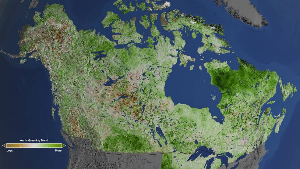
NASA has produced the most detailed picture to date of the widespread “greening” of the Arctic as a result of climate change.
The map above used data from more than 87,000 images collected over a period of 29 years by NASA’s Landsat satellites and clearly shows that the North American Arctic tundra is beginning to resemble warmer ecosystems.
The satellites measured peak summertime vegetation cover, using the amount of visible and infrared light reflected by the grasses, shrubs and trees to determine the type of vegetation present in an area. The map is made up of millions of pixels, each representing a 30 metre square parcel of land.
Green pixels on the map indicate where plants were larger or leafier than in the past, while brown pixels show where vegetation declined. Researchers found that overall, grassy tundra has increasingly given way to shrubland, and shrubs are growing taller and thicker, with the greatest greening occurring in northern Quebec and Labrador.
The video below summarizes the study’s findings; NASA scientists will now dive deeper into the data to understand how greening will impact water, energy and carbon cycling in the North American Arctic.
Environment
Microbes and mosses have demonstrated rapid growth in the last 50 years

People & Culture
A look at how small and medium-sized businesses on the continent are starting to play a bigger role in environmental sustainability
People & Culture
For generations, hunting, and the deep connection to the land it creates, has been a mainstay of Inuit culture. As the coastline changes rapidly—reshaping the marine landscape and jeopardizing the hunt—Inuit youth are charting ways to preserve the hunt, and their identity.

People & Culture
As the climate heats up, so do talks over land ownership in the Arctic. What does Canadian Arctic Sovereignty look like as the ice melts?