History
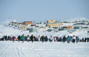
Throwback Thursday: Nunavut up and running
On April 1, 1999, Canada’s youngest population took control of its largest territory. Here’s how Canadian Geographic covered the story.
- 2880 words
- 12 minutes
This article is from Hakai Magazine, an online publication about science and society in coastal ecosystems. Read more stories like this at hakaimagazine.com.
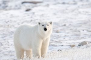
Perched like a figurehead on the bow of the boat, the girl hoists the harpoon. She scans the waves for a streak of white, a plume of red, guiding her to her target below. Around her, a chorus of outboard motors screams into the brisk breeze. Flocks of gulls keep raucous watch from above, while polar bears patrol silently on distant shoals. All are after the same quarry—a pod of beluga whales swimming along the coast of Hudson Bay in Nunavut, part of the Inuit homeland in northernmost Canada.
“There, over there,” come excited yells, arms waving toward a circle of roiling water about 20 meters ahead. A young beluga, wounded by gunshot, is thrashing. A fin stabs the surface. Then a patch of belly flashes toward the sky. Now it’s up to Rolanda Uquuyuq Tiktaq, a young Inuk out on her first hunt, to plant the harpoon and claim her first kill.
Tall and slender, the middle schooler from Arviat—a 2,900-some, predominantly Inuit hamlet on Hudson Bay’s west shore—may not fit your classic hunter stereotype. She rocks a diva headwrap, glam rhinestone sunglasses, and a stylish maroon parka. Her favourite subject in school is math. She wants to be a cosmetologist when she grows up. But she also wants to learn the life skills of her ancestors and gain the environmental wisdom passed from generation to generation of Inuit hunters.
As Rolanda, a native Inuktitut speaker, puts it in her shy English: “I want to learn about the land.”

It’s a chilly, grey evening on this vast inland sea some 600 kilometres south of the Arctic Circle in August 2021. We’re here with the Ujjiqsuiniq Young Hunters, an Arviat program schooling youngsters in Inuit Qaujimajatuqangit, or IQ—the systematic “way of knowing” that has guided life here for millennia. Aimed at propagating the culture’s deep roots in the landscape, passing along time-honoured practices in monitoring—ujjiqsuiniq is a process of keen observation—and sustaining their ancestral hunting grounds, the program is preparing today’s youth to become the Inuit land stewards of the future.
“Being respectful of the environment … living with the land in mind … these traditional principles and how strongly they were followed are things we try to pass on to youth today,” says Shirley Tagalik, board chair of the nonprofit community wellness group Aqqiumavvik Society, the parent organization of the Young Hunters program. The nomadic peoples who inhabited this coastal tundra for some 5,000 years relied on the land and sea for all their resources. “So, of course they had to be not just respectful,” Tagalik says, “but they had to be good stewards, good conservers of those resources.”

The Young Hunters are part of a growing global recognition of Indigenous environmental knowledge and stewardship. The project is supported by the Canadian government’s Indigenous Guardians Pilot Program, a recent initiative promoting Indigenous leadership in preserving their ancestral lands and resources.
For Inuit, that’s the traditional responsibility of hunters. Life here depended on hunters knowing the ways of animals such as caribou, whales, and seals. Elders taught new hunters how to safeguard the ecosystem and harvest sustainably so the animals would be there for the next generation. Even after the Canadian relocation programs of the mid-1900s forced Inuit to leave their seasonal camps and settle permanently in often-distant places, hunting remains central to their descendants’ identity and way of life. And “country food,” such as maktaaq—raw whale skin and blubber—is an important staple in a place where other options are limited and expensive.
But the world around Hudson Bay Inuit is rapidly transforming. Straddling the Arctic Circle, the region is in one of the fastest-warming places on the planet. Hunters today face conditions their ancestors never could have imagined, including thinning sea ice, disrupted seasons, and disturbed animal behaviours. What’s more, due to a geological phenomenon known as glacial isostatic adjustment, the land here is rising as it rebounds from the crush of ice sheets that vanished thousands of years ago. Paradoxically, this means that while most of the world’s coasts in our warming climate face an encroaching ocean, the sea level here is actually plunging. Shoals and reefs, once deep underwater, are emerging as new, unmarked hazards for boaters on the shallowing bay. To maintain access to crucial community resources, the Young Hunters have followed the IQ principle of qanuqtururangniq—finding innovative and resourceful solutions—and are using pioneering technology to survey the bay’s largely uncharted floor. The nautical data will be shared with government hydrographers and made available to the public. Photographer Shanna Baker and I have come here to see how these young Indigenous scientists are deploying next-generation tools with past generations’ guidance to help make navigating this changing seascape safer for everyone.
When we arrive in Arviat, though, we find all other activities have been preempted by whales. The annual beluga migration from their summer breeding grounds near Churchill, Manitoba, north to their winter territory in Hudson Strait was at least two weeks overdue this year. Then, this morning, came the news. A pod of these small, torpedo-shaped cetaceans—around the length of a Mini Cooper, but packing a dense, nutritious layer of blubber—has finally been seen heading this way. Along with three boys and two girls from this summer’s group of Young Hunters, plus instructors, drivers, and helpers, we hop into a trio of motorboats and spend the day racing around Hudson Bay.
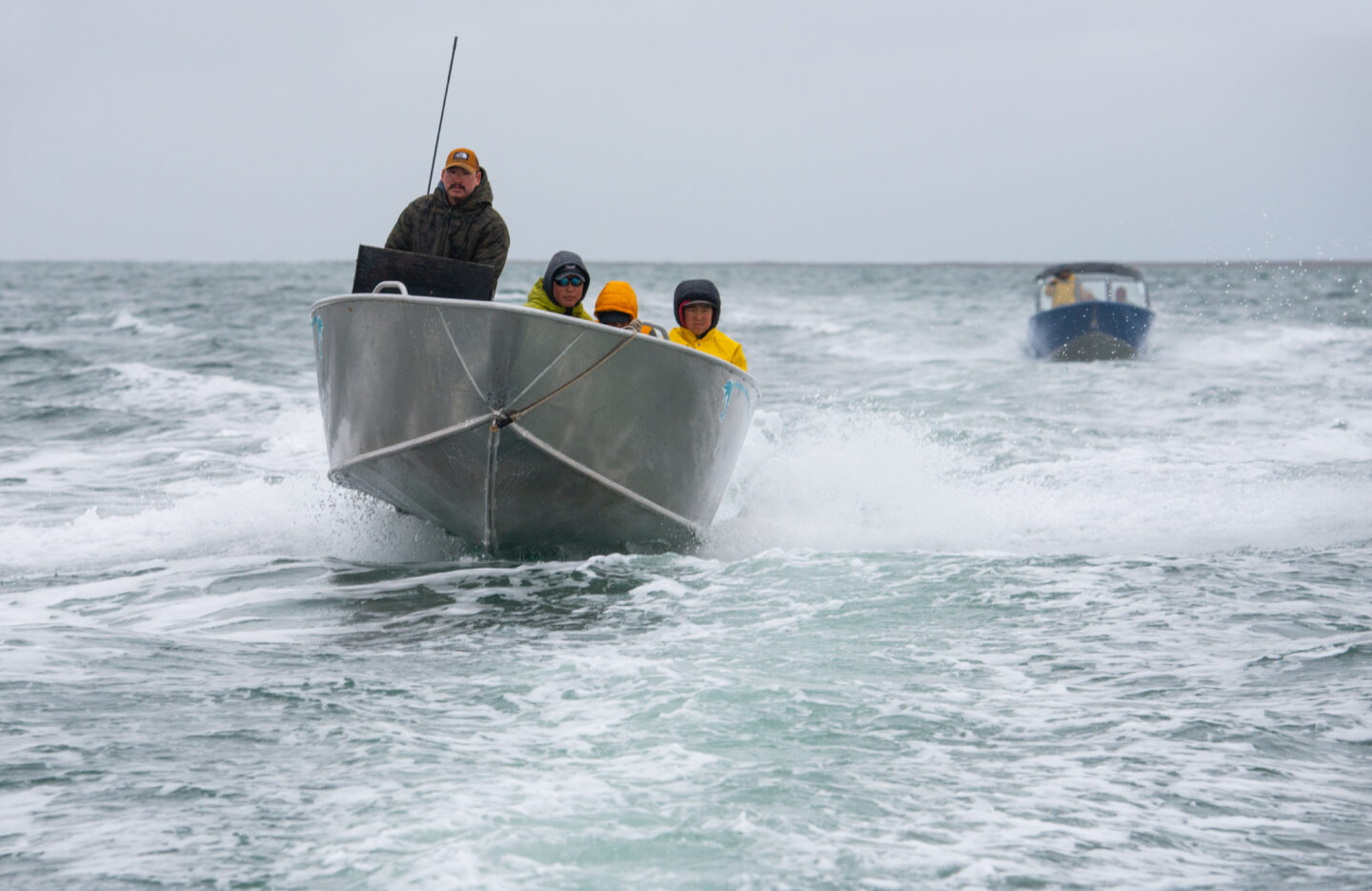
We’re not alone—it seems like all of Arviat is out chasing the pod. All day the CB radio on our boat growls with a mix of Inuktitut and English, reporting sightings that have so far fizzled out. But late in the afternoon, the radio chatter suddenly reaches a new, frantic pitch. Whales to the south, come the excited reports. This time for sure!
We take off, zigzagging full tilt through an obstacle course of nearly invisible obstacles. It’s a heart-pounding demonstration of the rising land below.
“There’s a bunch of low areas that weren’t here a couple years back,” Aupaa Irkok, a Young Hunters instructor, tells me, pointing toward a stretch of rocky fingers riffling the waterline off starboard. Irkok peers out from under a black cap pulled down to eyebrow level, emblazoned with a pair of the traditional sealskin boots known as kamiit. Those are just the visible hazards, I’m reminded. As the land pushes upward, a battery of moraines, scarps, and other features on the seabed beneath us is pushing ever closer to the surface.
“The world is moving itself, like redrawing,” Irkok observes in English inflected by the rolling cadence of Inuktitut, concluding with “Ii” (local dialect for “yes”). The kamiit bob as she nods.
It’s evening, but the northern sun is still high when we finally reach the whales. Several boats are already carving circles around the pod. Shots crack across the water. Smoke and the sulfur smell of gunpowder lace the evening air.
Speedboats and rifles have replaced kayaks and spears. But planting the traditional unaaq (harpoon) still marks an Inuit hunter’s first qinalugaq (beluga catch). That’s a major milestone in a young Inuk’s life. A bridge between future and past.
Rolanda is nervous as she waits for the chance to strike. She feels proud and excited and a bit shaky. The long, wooden shaft with a sharp metal tip is heavy and hard to handle as she points it left, then right, trained on the darting whale. With Irkok’s coaching, she watches for the creature to surface, take a breath. Then she will hurl the harpoon.


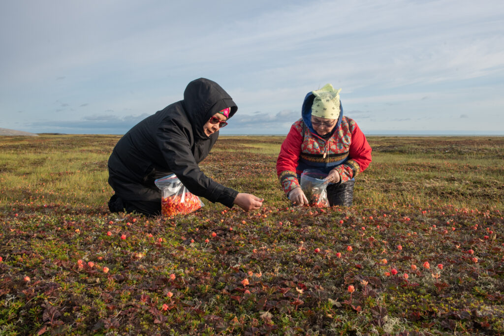
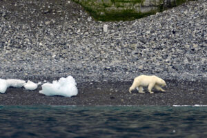
Stacked stone inuksuit stand sentinel over the tundra, where Joe Karetak patrols with a rifle as his wife and sister-in-law pick cloudberries on a blustery afternoon a few days later. Crouch-crawling along the marshy ground, gathering the small, salmon-colored fruit they call aqpiq for jams and pies, the women are in no position to watch out for polar bears.

Arviat, on the western Hudson Bay migration route known as Polar Bear Alley, is a favourite haunt for bears waiting for the winter sea ice to return. The bay here generally used to freeze solid enough for bears to hunt seals, their dietary mainstay, by November. These days, freeze-up often doesn’t come until December. That means these massive marine mammals are hungrier and on land for longer—to the detriment of both ursine and human populations. It’s one of the ways the disturbed climate is upsetting the precarious balance of life in these northern lands. Says Karetak, a burly hunter with a philosophical air, “some of the seasons in the year are changing time.”

Karetak, who teaches traditional Inuit knowledge for the Aqqiumavvik Society, has seen a lot of changes around Arviat since he was born here in a blizzard six decades ago. The hamlet’s name, for instance. It was called Eskimo Point when he was a child, a handle bestowed by foreign whalers in a past era. In 1989, residents voted to change it to a name based on arviq, Inuktitut for bowhead whale. Ten years later, Arviat, along with a vast swath of land stretching from the Manitoba border to the Arctic Ocean, changed from being part of the Northwest Territories to being in the new Inuit territory of Nunavut: Inuktitut for Our Land. It was the first of what are now four regions in northern Canada that make up the Inuit homeland called Inuit Nunangat.
But as the people regain control of their ancestral homeland, powerful forces are reshaping the environment. Due largely to the greenhouse gas emissions of societies far to the south, Hudson Bay air temperatures have climbed more than 2 °C since the late 1980s. Waters have warmed nearly as much in some parts. Permafrost is thawing. Sea ice—crucial for winter hunting and travel and a vital habitat for marine life—is not only forming later, it’s breaking up earlier, and becoming perilously thin. And as emissions continue essentially unabated, a recently released Climate Atlas of Canada projects that during the next 30 years, Arviat will be nearly 3 °C warmer on average than it was around the turn of the century.
The off-kilter climate is hobbling the country food harvest. Weather has turned unpredictable, putting hunters out on the land and water at risk of sudden, life-threatening storms. Animal habitats and behaviours are changing, undermining generations-long knowledge of when and where to hunt. The tundra is greening, with normally calf-high Arctic willows shooting up to shrub height in places, impeding travel. And previously rare foreign invaders such as killer whales are moving in.
On top of this “new” and dramatic climate upheaval, environmental change set in motion nearly 20,000 years ago—the wane of the last ice age—is dealing a double whammy to the Hudson Bay Inuit way of life. As the climate warmed toward the end of the late Pleistocene, the Laurentide Ice Sheet that had buried the region more than three kilometres deep began to melt. By the dawn of the Holocene some 8,000 years later, the Earth’s crust, liberated from the icy weight that had pushed it down several hundred meters here, had started to spring back. Glacial isostatic adjustment, also known as postglacial rebound, has been rearranging the landscape ever since.
While land is readjusting across the previously glacier-covered north, the Hudson Bay region, former home to some of the planet’s thickest and most-persistent ice, is experiencing some of the greatest uplift, says Karen Simon, a geoscientist at the Delft University of Technology, Netherlands, who has studied the rebound around Arviat. The west bay was near the ice sheet’s bullseye. According to Erik Ivins, a researcher at NASA’s Jet Propulsion Laboratory, GPS observations and models indicate a current rise rate of 10 to 15 millimetres a year.
That’s more than double the rate of most other rebounding parts of the north. And in today’s warming climate, the accelerating loss of the planet’s remaining ice is boosting the uplift by as much as another millimetre per year. What’s more, the crust and mantle below are slowly creeping sideways as the balance of weight on the Earth’s surface moves from land to sea.
Arviat long-timers are well aware of the shifting topography.
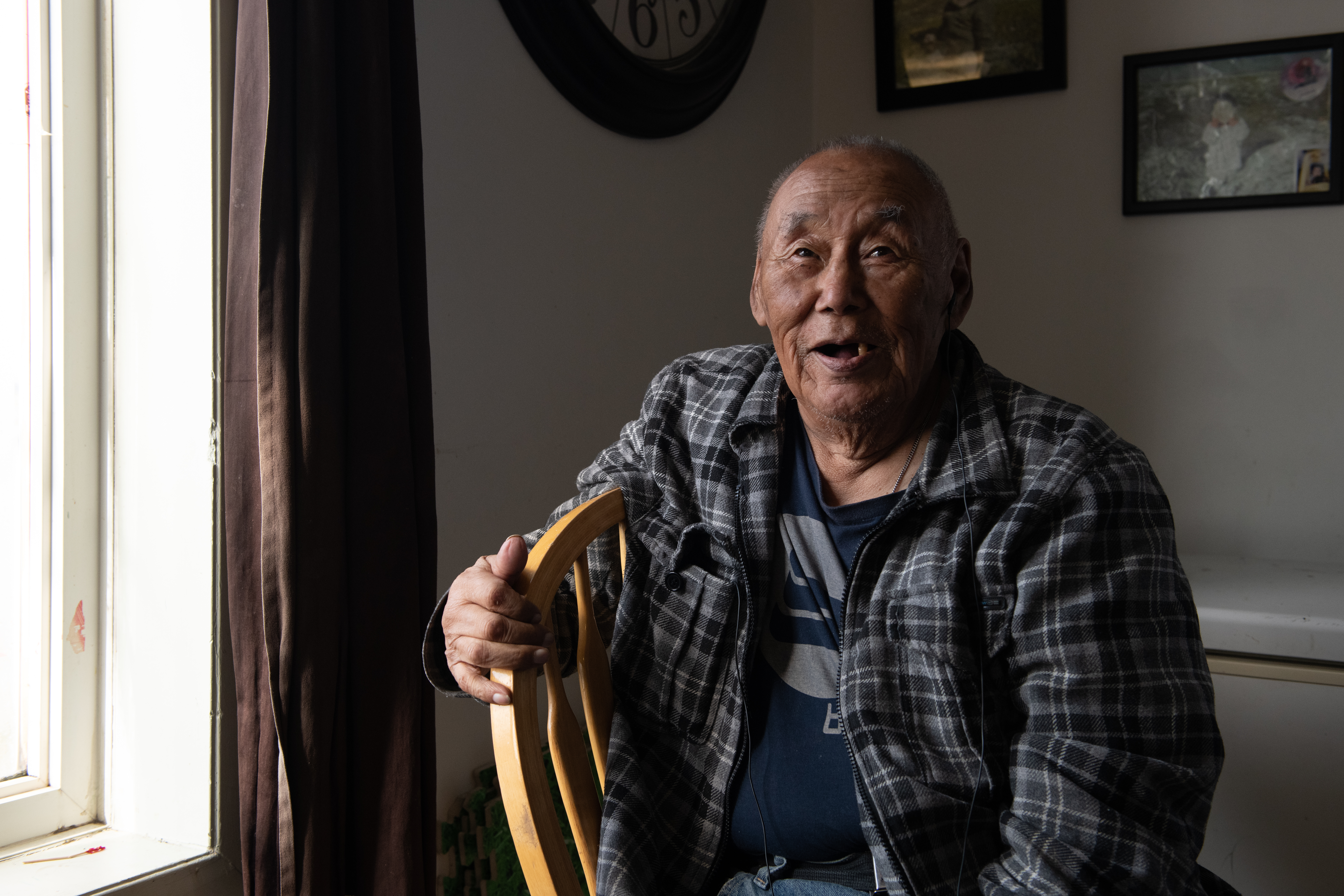
The earth beneath Nunavut has moved, Elder Louis Angalik tells me through a translator. Seated at his breakfast table in his cozy house in Arviat, the octogenarian tents his hands to show how the terrain has pitched since the days when he and his family spent most of the year out on the land. He speaks of following the caribou herds, hunting seals, trapping foxes, and selling the pelts to the Hudson’s Bay Company trading post that used to stand nearby.
“The sky is different now,” Angalik says. “The sun is higher. The sea is getting shallower.”
Indeed, while the global ocean is rising an average 3.6 millimetres a year due to expanding water and melting land ice, up here, that ocean rise is outpaced by land rise—resulting in a sea level plunge. The height of the bay at nearby Churchill, Manitoba, dropped nearly three-quarters of a meter over the past 80 years, long-term measurements by the US National Oceanic and Atmospheric Administration show.
For Hudson Bay, that adds up to a serious scoop out of this already-shallow body of water. Although it’s the second-largest bay in the world—surpassed only by the Bay of Bengal—thousands of years of incremental rebound have left it unusually shallow for a bay of this size. And the sea level along Hudson Bay’s west coast could drop some three-quarters of a meter farther by century’s end.
The stretch marks on the distending land are visible from the sky. Ridges of shoreline extend like tree rings along Nunavut’s coast, marking the beaches’ growth. The flight path to Arviat’s tiny airport crosses what used to be an island—Qikiqtaarjuk—with a historic site linked to the legendary Inuit voyager Kivioq. Today it’s a peninsula, tightly stitched to land.
“The landscape is growing,” says Leo Ikakhik, astride his ATV on the spit of land east of town where the original settlement sprang up around a Hudson’s Bay Company trading post built in the 1920s. Nothing remains today but some rock outlines of long-gone buildings and the beached skeleton of a York boat that once served the post. Now it’s a hangout for polar bears, and Ikakhik is one of Arviat’s official polar bear patrollers. From August to freeze-up, he rides up and down the shoreline, armed with binoculars and a rifle, calling the town hotline when he spots bears coming in from the bay. He has just given me a stern warning for wandering too close to the water for his liking. Then he settles back in his seat, squints into the biting wind, and points toward the bay.

“All of this you see here is the land rising,” Ikakhik tells me. We gaze at the rocky flats stretching half a kilometre out from shore and smell the seaweed rotting in shallow pools where once there was navigable water. “None of this used to be here,” he says.
That spells trouble for Arviat, where life revolves around the bay. Boats clutter the rocky shoreline, clatter on trailers towed by ATVs over the town’s unpaved streets, clang on the water at all hours as hunters and fishers ply the long northern summer days.

Lately, those boats have been running into shoals that never posed a problem before.
Karetak, who has navigated these waters for decades, hit one on his first trip out on the bay this summer. “I was going in a direction that I never hit anything before. I never hit anything in that line,” he says, his quiet voice rising with vehemence. “And all of a sudden, I looked down, I was like, ‘Wow, this is really shallow!’” But it was too late to avoid a run-in that dinged his brand-new propeller.
Lots of other Arviat boaters have similar stories. One of them is Andrew Muckpah, who coordinates seabed mapping for the Young Hunters program. A couple of years ago, he hit a submerged rock, causing major damage to his motor.
“We went on top,” Muckpah says with a sheepish smile. “Crashed down. Had to jump in the water to get the boat off.” The cost for repairs added up to CAN $1,500, which he can’t afford. And even if he could, it would take a long time. There’s no boat shop in Arviat, so parts must be found elsewhere and shipped.

Unmarked hazards are a widespread problem for mariners off Canada’s north coast, where the lay of the sea bottom is woefully unknown. Only around 14 percent of the region’s waters have been adequately surveyed, according to the Canadian Hydrographic Service (CHS), the branch of Fisheries and Oceans Canada responsible for this task. Not only are updated charts vital to Indigenous communities like Arviat that rely on marine resources for subsistence, they’re also critical for commercial traffic—which has tripled across the Canadian Arctic in recent decades—and continues to climb as waning sea ice opens up new routes. For large vessels, an accident in these waters could unleash a dangerous and difficult-to-clean spill. And passenger rescues are challenging and costly, as at least two cruise ships that have run aground here in recent years show. But the expanse is enormous—the Canadian Arctic waters cover more than two million square kilometres, an area larger than Mexico—and mapping resources are thin.
“We will never have enough resources to cover the Arctic,” says Mathieu Rondeau, a CHS engineering project supervisor. Most methods of seabed mapping, such as with multibeam echo sounders and water-penetrating lidar, require expensive equipment and extensive training. High-traffic shipping and commercial fishing zones get top priority, leaving few resources for other areas—especially remote and relatively untraveled reaches of Hudson Bay. And with the seafloor steadily rising, charts here do grow out of date.
The only way this vast region can be fully mapped, Rondeau says, is with the help of citizen scientists. That’s where the Young Hunters come in.
As Muckpah and I speak, he’s piloting the Young Hunters’ motorboat in a grid pattern just off Arviat’s southern shore, following lines on a computer screen in front of him. It’s like pacing on water. A kilometre up, turn, 10 metres across, turn, a kilometre down, turn again. Repeat.
As he drives, sensors on a pole clamped to the side of the boat mark the precise position, gauge bottom depth, adjust for instrument-tilt from waves, and send the readings to a data logger. Instructor Irkok and Young Hunters helpers Lucas Owlijoot, Jacque John Mikiyungiak, and Joe Shamee keep an eye on the equipment and watch out for rocks. It’s the last day of August, and I’ve already left Arviat, but I tag along virtually, by smartphone.

The surveying system, called HydroBlock, is designed to collect high-quality bathymetric data while being affordable and easy to use. The goal is to eventually enable coastal communities to create their own nautical charts, says Julien Desrochers, who is on board today as chief operating officer of M2Ocean, the Quebec company marketing the system.
Summer 2021 is the Young Hunters’ second year profiling Arviat’s underwater terrain with the HydroBlock. Desrochers is teaching them how to operate and maintain the equipment, decide where to survey, plan out their route, and gather data. In 2020, they surveyed 2.4 square kilometres, about half of the inlet near Arviat. The results were used to produce a bathymetric chart with shallow areas highlighted in bright red; it was posted for the public in the organization’s office and on its Facebook page. The data was submitted to the CHS, says Desrochers, who hopes the Young Hunters will go on to teach the techniques to other Indigenous coastal communities.
The project grew out of earlier research Aqqiumavvik Society board chair Tagalik had participated in, called Arctic Corridors and Northern Voices. That University of Ottawa–led study gathered Inuit knowledge on marine areas with cultural or ecological significance, to help design low-impact shipping routes for the increasing Arctic traffic. The findings showed the need for data on Arviat’s changing underwater landscape.
“It was increasingly unsafe to navigate those waters,” Tagalik says. But since Arviat is not on any core shipping routes, she realized that mapping the seabed here was a low priority for the government and maritime industry. The community would have to do it on its own.
Tagalik found her way to Desrochers, who was looking to test the community-geared hydrography system he was involved in developing with the Interdisciplinary Centre for the Development of Ocean Mapping. The Young Hunters’ first try, in 2019 with a precursor to the HydroBlock, didn’t go well, because Arviat’s waters were usually too choppy for the equipment to work properly. After trying the new system the following year, the program bought it. The government and charitable foundation grants that provide the organization’s main source of funds covered a small part of the cost, but the $36,000 total price tag for the equipment and training took a lot of extra fundraising, Tagalik says. The program hopes to acquire a second unit and expand its mapping efforts in the future.
Arviat’s project is a showcase for crowdsourced bathymetry: citizen scientist–boaters using their own navigational equipment to help fill in the missing details of the ocean floor, says Rondeau. At present, less than one-quarter of the global ocean has been surveyed, according to Seabed 2030, an international project aiming to map the entire ocean by the end of this decade. In addition to navigation, expanding knowledge of the subsea terrain is important for conservation, managing fisheries, and improving the accuracy of future climate models.
Mapping the bay is just one of the ways Inuit youth in Arviat are bridging Western and traditional knowledge systems to chart their changing world. In the winter, they contribute to SmartICE, a sea-ice-monitoring project conducted by Inuit communities along Canada’s northern coasts. Its high-tech guidance is needed as climate change disrupts long-standing experience of how to gauge ice safety. In a shed on a cotton grass–covered meadow, a qamutik (wooden sled) fitted with ice-thickness sensors waits for winter. When the bay freezes, the device will be towed over it with a snowmobile, mapping real-time ice conditions for a public app named SIKU. The Young Hunters also work with scientists to monitor wildlife health, analyze water quality, and collect other data on the changing environment.

The tools are cutting edge but the skill—ujjiqsuiniq—is the timeless core of Inuit knowledge, says Kukik Baker, executive director of the Aqqiumavvik Society.
Baker, a youth outreach specialist, founded the Young Hunters program in 2012. She doesn’t like taking credit for it: “We [Inuit] are traditionally humble. We don’t boast about things that we do.” But Baker is a dynamo. As we speak in the small Aqqiumavvik Society office cluttered with papers and books, she fields a steady stream of visitors and phone calls, while two laptops whir in front of her. She handles it all with a patient smile.

In eight-week sessions held throughout the year, groups of middle schoolers, high schoolers, and young adults practice both high-tech and traditional ways of knowing, Baker tells me. While they’re in the boat mapping, for instance, they’re also observing wind and water, watching animal behaviour, and reading the weather. “We want our kids to grow up to have skills to be able to use the best of both worlds,” she says. Around 200 Arviat youth have gone through the Young Hunters program as of summer 2021.
But charting this northern coast is challenging. The work can only be done during the brief summer window when there’s no ice. That’s the windy season, however, and conditions are often too rough for boats. Even on “good” days in the cold, blustery bay, equipment and operators can take a beating.
For the Young Hunters, tacking back and forth in a boat for hours collecting data is tedious. “It’s kind of boring, but fun,” middle schooler Don Don Ikakhik tells me one stormy Friday, as the group hangs out in the hamlet’s library, playing games on their phones and waiting to go home for lunch. It’s late August, the month named Akullirurvik, or Middle Season Moon, according to the calendar on the wall. The new school year is about to start.
“What’s the fun part?” I ask. “Going back,” Don Don replies. To shore, that is. The others nod and laugh.
They do understand why it’s important. “So people will know where all the rocks and shoals are,” Rolanda says. But they’d much rather be out hunting. Hunting trumps everything when belugas are around.
Despite the challenges, these young Indigenous scientists are steadily building knowledge through research conducted at their own pace, on their own terms. They eventually go out 12 days in the summer of 2021, surveying another roughly three square kilometres. Another colour-coded chart is posted on Facebook. The data is again shared with the CHS.
This summer, another group of novice Inuit hunters will pace the water in boats. And after freeze-up, they’ll haul high-tech qamutiks over the ice. They’ll not only be plotting safe routes to resources for their community and charting better navigation in the north, they’ll be mapping tomorrow’s Inuit identity onto the new face of their homeland.
Tea and conversation with Tagalik help me see how the wisdom of the Inuit ancestors sustains the environment today. As we sit in her cheery blue house overlooking the bay, she tells me the story of an elder who is walking in the countryside and sees a fox skeleton on the ground.
“‘Oh, you must be tired lying on that side all the time,’” she says, quoting the elder’s words to the fox. “And he turns it over.”

Scientifically, Tagalik says, that action helps break down the bones and return their nutrients to the land. But to the elder, it’s a way of respecting the animal, as Inuit traditions direct.
Tagalik, a native of Quebec, is a longtime scholar of Inuit knowledge and culture. She moved to the hamlet as a young schoolteacher in the 1970s, intending to stay two years. Then she married an Inuk, embracing the language and way of life, and more than 45 years later, she’s still here. Over a bowl of cloudberries, we discuss Inuit Qaujimajatuqangit, and how it can inform the future guardians of this warming, transforming world.
“Being a good steward is almost self-serving in a way,” Tagalik continues. “Because what you put out in the world is what will come back to you. That’s a core belief.” In addition to respecting nature, she says, Inuit traditions emphasize paying close attention to the environment and carefully monitoring changes. And using innovative pirqutiit—tools and technology—to devise solutions or ways to adapt. The Young Hunters, she says, are learning to build all those principles into their lives.
Karetak also talks about respect when I ask him what Qallunaat—non-Inuit “southerners” in a place where almost everything is to the south—can learn from the guardians of this far-northern coast to help protect our natural world.
“You have to have a proper relationship with the land, as you would with another person that you respect,” he replies. “You don’t do things you think would offend the land.”

Traditional Inuit laws treat the land as a living entity with the same legal standing as humans, says Karetak, who has spent years researching the unwritten directives that were lost to colonialism. A strict set of location-specific rules governed land use, such as how long people could stay in one place before they had to move on and let the land recover. While most of those laws applied to a nomadic lifestyle that is no longer possible, he says, the core environmental stewardship principle remains.
“It’s simply based on what the land and water can provide,” says Karetak. “You let the land and water take care of itself. So you take only what you need and can handle well.”
Irkok teaches the Young Hunters much the same.
“One of the duties of Inuit Qaujimajatuqangit is respecting your surroundings,” she tells me. “We try and teach them Inuit ways. For example, if we find six eggs [in a nest], we’ll take three.”
Respect your surroundings. Treat the land as a kindred being. Read and respond to the environment’s needs. Place-based principles and practices like these have guided Indigenous land stewards for generations. Long disregarded by Western scientists and land managers, appreciation of this deep well of ecological knowledge is growing. New national initiatives, such as Canada’s Indigenous protected and conserved areas—one of which is being created in the Seal River watershed just south of Arviat—are giving Indigenous communities new agency to manage their ancestral lands and waters. Traditional knowledge is being incorporated into scientific research, and the concept of nature having legal personhood and rights is now finding its way into Western law.
But for the next generation of Indigenous land stewards, the challenge is to keep that venerable wisdom alive.
Like young people everywhere, Inuit youth today are tethered to the internet, glued to their mobile phones. “They do have more of the Western culture than they do our traditional one,” says Baker. They are adept with technology and quick to catch on to the latest gear. But to gain Inuit Qaujimajatuqangit, she says, they need to reconnect to the land.
That means following the path of their ancestors to become Inuit hunters. It means learning traditional Inuktitut place names, and the place-based knowledge those names convey. It means making their own pana, or snow knife, and knowing how to use it to build a life-saving shelter in a winter storm. It means knowing the rhythms of the ecosystem like they know their family’s habits, being as familiar with the landscape as with their own skin. Above all, it means spending time with elders and hearing the stories teaching Inuit wisdom and ways.
“It’s helping them to come back to the beginning,” Baker says. “Going back over the bridge backwards.”
Up here, where the world is redrawing itself, the bridge to the past provides hope for the future.
Hunter Gordy Kidlapic sits at his kitchen table with his young grandson in his lap. Over an immense fresh Arctic char splayed across the tabletop between us, we discuss how the impacts of old and new climate change—one driven by nature, the other largely by the actions of Qallunaat—are combining. Already Kidlapic sees signs of a one-two punch on life around Arviat. Animals are changing “big time,” he tells me. Some fish, like the one in front of him, seem to be growing larger in the shallowing, warming bay, while other local marine life is being driven out. He’s seen a pod of around 50 killer whales causing seals and other sea mammals to “kind of run away.” On the tundra, a once-reliable hunting spot sports more plants and fewer caribou these days. And he’s worried by the polar bears that now roam the coastlands for months.

Still, his grandson is eager to hunt, and Kidlapic is beginning to teach him. “I think he’ll be all right,” he says.
Back on deck, Rolanda hears shouts and cheers. Don Don, who’s on another boat, has just gotten his first qinalugaq. Now it’s her turn. She watches the water. The long line of Inuit hunters in her family stands behind her.
Now there’s a bulging wave. An arc of grey. A spout.
Rolanda hurls the harpoon.
Reporting for this article was made possible by an award from the Institute for Journalism and Natural Resources. Aupaa Irkok, Wendy Shamee, and Stacey Kritaqliluk provided translation assistance.
This article first appeared in Hakai Magazine, and is republished here with permission.
History
On April 1, 1999, Canada’s youngest population took control of its largest territory. Here’s how Canadian Geographic covered the story.
People & Culture
Depending on whom you ask, the North’s sentinel species is either on the edge of extinction or an environmental success story. An in-depth look at the complicated, contradictory and controversial science behind the sound bites
People & Culture
For centuries, Inuit hunters in Canada’s north have co-existed with Arctic wildlife. Sharing their generational knowledge with visitors to the region is one way they are helping protect it.

People & Culture
Proclaimed in 1982 by Her Majesty Queen Elizabeth II of Canada, the Canadian Charter of Rights and Freedoms is intended to ensure that all Canadians can live a life without discrimination of any kind. On the 40th anniversary of its proclamation, Mark Bourrie asks whether the goals of the Charter have been met when it comes to Indigenous people living in Canada.