
Mapping
Map Monday – Bad Maps
Nothing will get you in trouble quicker than a bad map. For instance, scandal brewed in Romania when
- 604 words
- 3 minutes
This article is over 5 years old and may contain outdated information.
Mapping
Growing up, I was always taught that North America consisted of Canada, Mexico and the United States. I considered the question settled until I set out on a year-long tour that began in Guadalajara and wound south to the tip of Argentina. Along the way I was surprised to hear many Mexicans refer to people from the United States and Canada as norte americanos while on the other hand, many Argentines felt there was no real separation between a North and South America — at the end of the day we were all just Americans. Turns out continents are not as easily defined as I’d assumed.
The North American Free Trade Agreement just turned 20 years old, but technically is there such a thing as North America? Depends on who you talk to.
James Boxall, the Director of the GIS centre at Dalhousie University, says that over the centuries, monarchs, European colonizers and mapmakers divided up the continents. They decided, sometimes arbitrarily, that Europe was divided from Asia at the Ural Mountains while the Americas were deemed (and often still are by Europeans) a single continent.
“In classic geography it becomes a matter of what’s the tradition and what has been in the public domain for the longest time,” Boxall says.
But politics aren’t known for stable opinions or definitions, and ideas about what makes a continent can change based on political alliances; the Americas are sometimes divided at Panama’s border with Colombia into North and South, but before its early 20th century independence Panama was actually part of Colombia. Continental divisions can also be dictated by prejudice, as some have argued is the case in Turkey’s continued exclusion from the European Union.
For Boxall, it all goes to prove one thing: “geography can be messy.” But for him the division between continents is often just a convention to help in teaching and contemplation. “For all intents and purposes it’s just a way to generalize things to make it easier.”
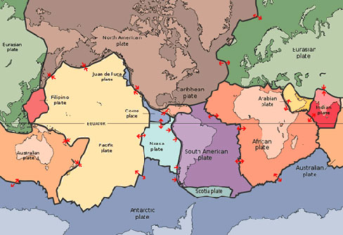
In the strictest physical sense, the Americas are split into three major tectonic plates called the North American, Caribbean and South American. The Caribbean plate roughly borders the North American one around the south of Mexico and just underneath Cuba and the Bahamas. It gives way to the South American plate near the Colombia-Panama border and along the north coast of Venezuela.
Indeed, as we’ve seen from the endless discussion over Turkey’s bid to enter the European Union, continents are often defined politically rather than tectonically. In the Americas, NAFTA is a trilateral agreement signed between Canada, Mexico and the United States in an effort to open borders to trade between the three countries. The name came about when the new agreement replaced the previous Canada-United States Free Trade Agreement.
Meanwhile the Americas make up a single “continental region” in the United Nations, though this region is subdivided two ways into a “northern America” region and a “Latin America and the Caribbean” region. In their interpretation, “northern America” includes Canada, the U.S., St. Pierre and Miquelon, Bermuda and Greenland — no Mexico.
“You can have an argument for weeks about whether Mexico is or isn’t part of North America,” Boxall says in reference to the different ways of examining the Americas.
But the most pertinent continental definitions may be more influenced by sports than politics. In the Olympics, countries are organized into five different continents, with the Americas representing a single unit. Meanwhile, FIFA’s world cup of soccer divides qualification in the Americas between the North and South, which more or less follows the tectonic definition except for the fact that the Guianas compete against North American teams.
“If I were looking at it I would fall back on the tectonic definition because it’s the only one that doesn’t get clouded with history, colonization, culture, politics and the changing nature of treaties and global relationships,” Boxall says. But between politics, sports and the raw physical makeup of our shifting earth, nobody seems to completely agree on the geographical makeup of our continent.
How do you define North America? Let us know in the comments or tweet us @CanGeo with hashtag #myamerica.
Mapping
Nothing will get you in trouble quicker than a bad map. For instance, scandal brewed in Romania when

Mapping
Maps have long played a critical role in video games, whether as the main user interface, a reference guide, or both. As games become more sophisticated, so too does the cartography that underpins them.
Mapping
Canadian Geographic cartographer Chris Brackley continues his exploration of how the world is charting the COVID-19 pandemic, this time looking at how artistic choices inform our reactions to different maps
Mapping
‘Maps aren't magic,’ says University of British Columbia prof — but during disease outbreaks, they can help us sort good information from bad