This article is over 5 years old and may contain outdated information.

Mapping

Magnetic maps helped 18th century mariners

How navigators kept track of an unseen force that could affect their course

  • May 23, 2016
  • 210 words
  • 1 minutes
Map Expand Image
Advertisement
Advertisement
Advertisement

Never mind the wind, waves, storms, shoals and countless other factors that once made sailing across an ocean an incredibly complex task fraught with danger.

Perhaps the most confounding aspect of a navigator’s life at sea was trying to account for the phenomenon of magnetic variation (also known as magnetic declination): the angle between magnetic north and true north that changes with location and over time due to fluctuations in the Earth’s magnetic field.

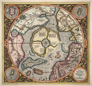
The map pictured here, published by French hydrographer Jacques-Nicolas Bellin in 1765, shows curved isogones — imaginary lines that connect points on the Earth’s surface having equal magnetic declination — and was used by mariners to keep their ships on course.

Each isogone is marked with a number that represents the degree of variation between magnetic north and true north. If there was a negative declination (where magnetic north is west of true north), navigators would add the number to the compass bearing; if there was a positive declination (where magnetic north is east of true north), they’d subtract it.

*with files from Isabelle Charron, early cartographic archivist, Library and Archives Canada

Click here to read about a controversial theory linking global warming to changes in the Earth’s magnetic field

Advertisement

Help us tell Canada’s story

You can support Canadian Geographic in 3 ways:

Climate Change Solutions

This story is from the June 2016 Issue

Related Content

An aurora dances in the night sky

Science & Tech

Solar to the max

For scientists and northern lights rubberneckers, 2013 promises to be a once-in-a-decade opportunity to experience the sun’s magnetic power at its height.

  • 2456 words
  • 10 minutes
Temperature data from four international science institutions

Environment

Is climate change linked to geomagnetism?

Crackpot theory or viable explanation?

  • 706 words
  • 3 minutes

Travel

Rolling uphill in New Brunswick

For almost a century, Magnetic Hill has boggled the minds of visitors. Here’s a closer look at what makes this magical spectacle so intriguing.

  • 832 words
  • 4 minutes
Assassin's Creed Odyssey landscape

Mapping

Inside the intricate world of video game cartography

Maps have long played a critical role in video games, whether as the main user interface, a reference guide, or both. As games become more sophisticated, so too does the cartography that underpins them. 

  • 2569 words
  • 11 minutes
Advertisement
Advertisement