The story of the collective Canadian sacrifice and contribution to the Allied victory in the First World War, and how it established our uniqueness among nations and forged a Canadian identity at home, is well told. But fast-forward a century and those characters, their stories, are barely remembered.
That is, until you enter the domain of map specialist Gord Beck, custodian of the Lloyd Reeds Map Collection in the Mills Library at McMaster University in Hamilton, Ont. There, that past becomes present—and instantly palpable, thanks to a collection of 1,400 detailed First World War trench maps.
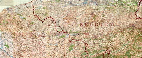
In another life, these maps were used by Allied generals to plot strategy, by gunners to aim their artillery and by front-line soldiers to plot maneuvers on the harrowing, intricate battle grounds where thousands died en route to victory in 1918. Because these different groups had different needs, the maps were produced at different scales, with different features.
Some highlight the terrain and other physical features, others emphasize equipment, settlements and installations, while still others include information on everything from equipment supply lines to ambulance routes. A number of the maps also have handwritten annotations and other personal details that put you right in the footsteps of the soldiers who held them.
In one case, says Beck, “we’ve got a whole collection from one guy who was an engineer and a medical officer in charge of clean drinking water. His maps include blueprints showing how to build water purification things in the field and a diary of every village he visited.”
McMaster began building the collection of maps, along with hundreds of air photos, in the early 1970s. It added a significant chunk of new material—some 900 maps—in 2009 when it acquired the collection of renowned English historian Peter Chasseaud, making it the second largest collection of its kind in Canada. By 2014, everything was digitized and freely available for download.
“We have the biggest collection in the world,” says Beck. “And so we get questions and requests from around the world every day.”
The maps were drawn by teams of military cartographers working behind the lines, relying on aerial photos shot from Royal Air Force aircraft (including Canadian fliers) under enemy fire to reveal details of both Allied operations as well as enemy activities and installations. Beck marvels at the bravery and the accomplishment.
“Airplanes had only been around for about 10 years before the war started,” he says. “To get into one of those rickety things and then go up to 13,000 feet and be told to fly straight and take pictures while people shoot at you? I mean, it’s just incredible.”
Besides depicting on-the-ground realities for soldiers at the front, the maps also represent the rapidly evolving state-of-the-art cartography of the day and were the first maps created using air photos. And it’s here, too, as the Drawn to Victory documentary depicts, where Canadians played a leading role. Their efforts not only helped win the war and advance the technology, but they returned home armed with that knowledge where it was readily deployed and refined to start the mapping of Canada.
So when you’re looking at the maps, you’re seeing more than just the story of the First World War coming to life, says Beck. You’re also viewing the output from the origins of many of the mapping tools and techniques still in use today. “We use satellites now, the cameras have changed but we’re still doing the same thing,” he says. “Cities still use airplanes, but it’s digital photos. They’re still using the same processes of the flight lines and the overlapping images. So the system is still the same.”
As both a geographer and a Canadian, Beck feels doubly blessed to have spent the past 13 years building and promoting the collection. “I’m glad to be involved,” he says. “It’s such an important story, it was such a pivotal time.”
Click here to explore and zoom in on tiled historical maps from the First World War (All items in Digital Archive are licensed under Creative Commons Attribution-NonCommercial 2.5 License, unless otherwise indicated.)