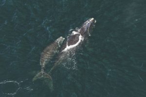
The conditions for the photo were perfect: no clouds, no waves, and hundreds of whales softly skimming the surface of Cape Cod Bay in Massachusetts. In that one image, Hodul spotted 72 North Atlantic right whales out of a worldwide population of maybe 350. The species is one step from extinction, but incredibly, researchers still don’t know where half of the population goes each summer. Satellites could fix that.
Everyone, however, is fighting for time on the WorldView-3, Hodul says, and a single image can cost tens of thousands of dollars. But issues of coverage, cost, and clarity will change with time. One company is ready to launch a chain of six commercial satellites this year, while another is developing a satellite with resolution three times sharper than the WorldView-3.
While the engineers build more satellites, whale researchers still have plenty of work to do on Earth.
Right now, says Hodul, the best way to spot whales by satellite—whether the images were taken specifically for finding whales, or snapped for other reasons—is to have someone painstakingly go through each image. “You’re going to be looking at hours and hours of water with one or two whales interspersed,” he says.
An automatic whale finder would save everyone time, but there aren’t enough images to train an algorithm yet. “We need automation, but we need people to share their data,” says Hannah Cubaynes, a research associate at the British Antarctic Survey. Ideally, the growing number of researchers using satellites to search for whales could contribute their results to an open library, including key details like species, location, and satellite used. Programmers could then build an algorithm that passively pinpoints whales and helps researchers fill in the blanks on migration routes.
The conservation value is clear, says Cubaynes: to save the whales, researchers first need to know how many there are. “Ultimately,” Cubaynes says of satellite research, “it’s finding whales where we’ve never been before.”
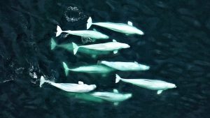
Watt isn’t packing up the homemade belugas just yet. She still has plenty of research questions in the Arctic. So far, she’s only surveyed for belugas in the fjords where they congregate. What happens when the whales are in open water overlapping with other species? Can a satellite distinguish one mammal from the next? Maybe it’s time to build some fake narwhals and find out.
This article first appeared in Hakai Magazine, and is republished here with permission.