
Environment
The truth about carbon capture
Carbon capture is big business, but its challenges fly in the face of the need to lower emissions. Can we square the circle on this technological Wild West?
- 5042 words
- 21 minutes
This article is over 5 years old and may contain outdated information.
Science & Tech
Where and how we live affect how much energy we consume. Here’s what Canada would look like if the provinces and territories were scaled to represent the amount of energy they use.

Where and how we live affect how much energy we consume. That is why the provinces and territories on this map are scaled to reflect their respective per capita energy-use values, measured in kilowatt hours (kWh).
Transportation and climate influence how much energy we consume. Industrial activity, also incorporated in these values, is partly why people in th west appear to be energy-guzzlers. Because energy is less expensive where it’s produced, westerners tend to use more.
Through the Energy Diet Challenge and the Classroom Energy Diet Challenge, six households and thousands of students found innovative ways to save energy. Their efforts show that every kilowatt cut tips the energy-use scale in a better direction.
The figures used to construct this map were gathered from Statistics Canada, whose data incorporate industrial activity in the energy demand values for each province and territory. What does that mean? The per capita energy-use values used to create this map incorporate the energy needed for industries such as auto manufacturers, pulp and paper mills and petroleum refineries, as well as individuals’ consumption.
This is reflected in the relative cost of energy. Alberta, an energy-producing province, has the lowest energy prices on a gigajoule basis for residential homes. Energy is also relatively cheaper in Ontario, Manitoba, Saskatchewan and British Columbia. In general, one can assume that people are less wary of how much energy they use when it’s more affordable. That means they tend to use more energy when they live in a place where energy is produced.
However, cost alone doesn’t determine how people use energy; weather is another important factor. The figures in this map represent a snapshot of energy use in 2009. In some areas, temperatures may have been exceptionally low that year, meaning people had to use more energy than usual to heat their homes. This map would vary from one year to the next, depending on temperature and weather patterns.
In general, the type of vehicle and distances traveled affect how much energy is used in transportation. Statistics show that more people own light trucks—specifically SUVs and pickup trucks—in Manitoba, Saskatchewan and Alberta, closely followed by Newfoundland. This figure is also reflected in the proportion of people involved in the agriculture industry, who would be more likely to use larger, energy-demanding vehicles. Quebec, on the other hand, has the smallest proportion of light trucks, which is one of the reasons it’s at the bottom of the list when it comes to per capita energy usage in transportation. Distance traveled also plays a significant role: in many rural areas, people have to travel long distances to get from one community to the next, whereas in many urban centres, people are more likely to rely on public transportation.
Environment
Carbon capture is big business, but its challenges fly in the face of the need to lower emissions. Can we square the circle on this technological Wild West?

Science & Tech
The Vice-President of Global Business Environment and head of the Shell Scenarios team discusses the Future Cities project and how Canadian cities can be more sustainable
Science & Tech
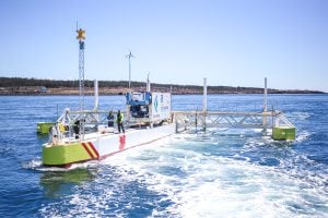
In the Bay of Fundy, technicians are putting a groundbreaking new tidal technology through its paces

People & Culture
Canadian Geographic’s eight Live Net Zero families explore ways to cut back on emissions related to electricity