Science & Tech
Into the storm: the Canadian transforming tornado science
Alberta-based computer scientist Mark Simpson can design anything he puts his mind to. So why has he chosen to chase tornadoes?
- 3246 words
- 13 minutes
Environment
Tracking the country’s extreme weather events to answer the question: are storms getting worse?

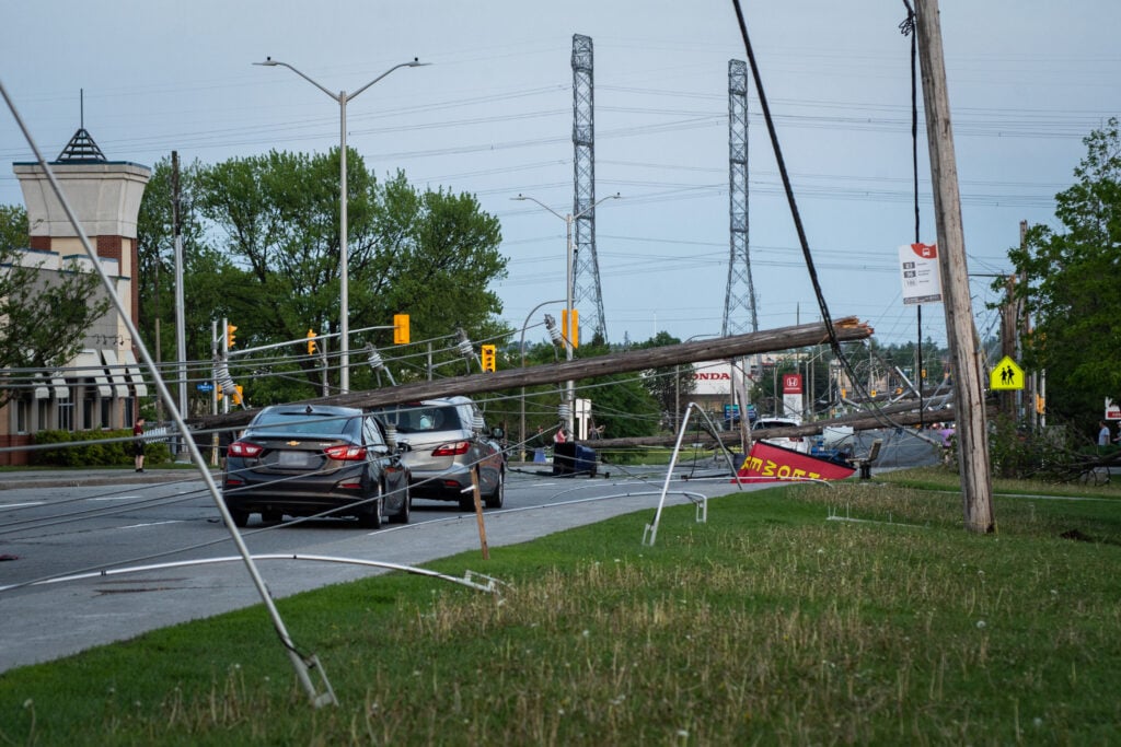
At around 4 p.m. on May 21, 2022, Salwa Saikaley was making coffee in the kitchen at the back of her south Ottawa home when her husband, Toufic, shouted from the front of the house: “Come here, come here, come here!”
Salwa ran to the glassed-in sunroom and looked out in disbelief. The skylight from their second-floor bathroom was lying shattered on the driveway, and the side of the house had been blasted with insulation. According to Toufic, a “black wind” had raced down the street, seemingly out of nowhere, tearing trees out by their roots.
Rushing back to the kitchen, Salwa looked out to see the neighbour’s tree lying across their backyard, the fence crushed beneath it. Their patio set had been flung across the yard, narrowly missing a window, and was now embedded in the dirt of their freshly planted garden, along with strips of aluminum siding, broken fence boards and more insulation. Up and down the street, similar tableaus of destruction suggested something stronger than an average thunderstorm had just torn through the suburbs south of the capital’s core: a metal signpost bent to a 45-degree angle, the snapped-off tip of a fir tree wrapped around it; roofs stripped down to their decking but, curiously, only on the western side. The Saikaleys had never seen anything like it.

“Within five minutes, everything was over,” Salwa Saikaley told Francis Lavigne-Theriault and Simon Eng the following afternoon as she toured them around her ruined property, feet crunching on broken glass. Eng, in a reflective vest and steel-toed boots, studied the remains of the skylight for a moment, then made a notation on a tablet.
Lavigne-Theriault is a researcher with the Northern Tornadoes Project, a research group at Western University in London, Ont.; Eng is a research meteorologist with the adjacent Northern Hail Project. As reports of significant damage began to flood social media in the wake of the storm, they hopped on the first available flight to Ottawa to see it for themselves. It’s always best if they can get to a scene before the cleanup begins, because the chaos tells a story. Like seasoned crime scene investigators, they look at details such as the direction of treefall and the type and extent of structural damage to create an initial profile of a severe wind event: How strong was the wind? How far and wide did it travel? And, most importantly, was it spinning?
The winds that blasted the Saikaleys’ neighbourhood on that May day were not tornadic, but they were exceptional. What had started as a few scattered showers in the midwestern United States gathered steam as the weather system crossed into Canada, eventually organizing into a derecho — a broad, long-lived line of fast-moving severe thunderstorms — that caused 12 fatalities and more than $1 billion in insured losses along a 1,000-kilometre long and 100-kilometre wide swath of southern Ontario, Quebec and New England. The derecho was particularly intense as it swept through Ottawa, producing a downburst with maximum winds of 195 kilometres per hour — strong enough to crumple steel transmission towers. (Though equally destructive, a tornado has spinning winds that scatter debris, while a downburst produces winds that slam down and out, resulting in debris thrown in the same direction as the winds are moving.) It was the second time in less than five years that the city’s power grid had been decimated by a severe storm, leaving some residents in the dark for 10 days or more and many wondering: is this the new normal?
That’s one of the questions researchers like Eng and Lavigne-Theriault at the Northern Tornadoes Project are hoping to answer. If we know where tornadoes and other types of damaging wind events are most likely to occur, now and in the future, we can issue timelier warnings, shore up infrastructure and change building codes to make our communities safer and more resilient in the face of severe weather. But to do that, researchers first have to figure out what “normal” even means in Canada.


The widest tornado ever recorded in Canada was on June 8, 2020, in northwestern Ontario — and no one saw it happen.
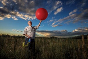
David Sills, executive director of the Northern Tornadoes Project, was keeping an eye on the radar that day as a series of thunderstorms tracked across the region. One showed strong internal rotation, suggestive of a possible tornado on the ground near Nestor Falls, south of Kenora, Ont. Sills ordered satellite imagery of the area. What he saw made him say, “Holy cow.”
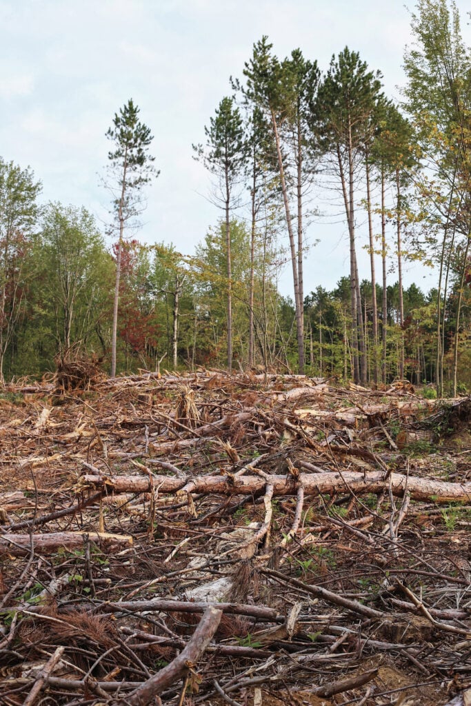
Every tree along a 32-kilometre swath of dense forest was flattened, trunks scattered here and there like matchsticks. At one point the damage path was around four to five kilometres wide — almost unheard of for a tornado alone. Through painstaking analysis of the satellite images and, later, higher-resolution aerial imagery that allowed them to map the chaotic patterns of treefall, Northern Tornadoes Project researchers determined that a tornado of at least EF-2 strength on the six-point Enhanced Fujita Scale had touched down, reaching a maximum width of 2.4 kilometres and spawning 33 downbursts along its edges, which accounted for the supersized damage path.
Hagan abides by the unwritten rule of chasing: when a tornado strikes a settlement, the chase is over, and the spectators become first responders.
There were no communities in the storm’s way, and only a single cottage, believed to have been unoccupied at the time, was damaged. So what does it matter, you might ask?
Sills, an affable man in his early 50s with an encyclopedic knowledge of Canadian tornadoes, recalls a tornado that struck the same region in 2009, killing three Americans at a fly-in fishing camp. “There are people [up there] in the summer. There are people — everywhere.”
And the data is important. Sills and his colleagues are on a mission to find every tornado in Canada — especially the ones that occur out of sight — to establish a baseline for the risk of damaging wind events in different parts of the country. Not only will this lead to more and earlier public warnings when tornadoes are likely or imminent, they say, but it will also contribute to a better understanding of how climate change is affecting the intensity, frequency and distribution of storms. The general thinking has been that climate change will bring about more frequent and intense storms, and therefore more tornadoes, but that’s not necessarily true, says Sills. “Tornadoes are really finicky in the sense that all the ingredients have to be perfect in order for them to form, and if you’re missing anything, it’s not going to happen. Climate change could take one of those ingredients out of the picture, and we could see big regional changes [in the frequency of tornadoes].”
When Sills joined Environment Canada as a severe weather scientist in the late ’90s, no one was tasked with maintaining a detailed database of tornadoes across Canada. Sills worked quietly away at building out the database and, eventually, led a project to create the first comprehensive national climatology for tornadoes, based on data from 1980 to 2009. The data available at the time suggested Canada could expect to see an average of 62 tornadoes per year, but there was an urban bias to the reporting. Powerful storms are common in the less densely populated parts of Canada, particularly central and northern Ontario and Quebec and the northern Prairies. Sills felt sure tornadoes were getting missed in the annual tally simply because no one was around to witness them.
In 2017, opportunity knocked. Sills got a call from Greg Kopp, a professor in Western University’s department of civil and environmental engineering. The university had received funding from ImpactWX, a Toronto-based social impact fund, for a pilot project to investigate possible tornadoes in northern Ontario. The hunt for Canada’s missing tornadoes was on.
Severe weather season that year was quiet in northern Ontario, but by analyzing high-resolution satellite imagery of the heavily forested landscape north of Montreal and Quebec City, Sills and Kopp managed to identify the largest cluster of tornadoes, called an outbreak, in Quebec’s history: 11 tornadoes in a single day, eight more than the official tally initially reported by Environment Canada. (The total tornado count from that event, based on ongoing analysis of satellite imagery, is now up to 23 in two days.)

The team set their sights even higher in 2018. “We were going to get every tornado in Ontario and then anything significant outside of Ontario,” says Sills. By then, word had started to get around about the project, and Sills discovered that what was now called the Northern Tornadoes Project could tap into an enormous network of severe weather enthusiasts who were eager to share reports and images.
In 2019, the project went national, and Sills was officially hired on at Western. At first, he says, the prospect of finding every tornado in Canada was daunting. “I was focused on just Ontario for a long time. But we’ve got such a passionate team, we can really punch above our weight, and in 2019 we showed that, across Canada, we can raise the number of tornadoes and get a better idea of what’s happening now.”
That year, the Northern Tornadoes Project confirmed 78 tornadoes across the country, including a rare EF-1 north of the 60th parallel in Fort Smith, N.W.T. As storm season kicked off in 2020, Canadians were isolating to mitigate the spread of COVID-19. The first tornado of that spring — an EF-0 in Saanich, B.C. — was captured by a home security camera, underlining for Sills the importance of crowdsourced reports and evidence at a time when travel was discouraged and sending ground crews out to investigate events would be difficult and risky. In spite of the pandemic, the Northern Tornadoes Project confirmed 108 tornadoes in 2020 and 117 in 2021 — nearly double the official national average. By 2022, the sixth year of the program, Sills had started to notice some interesting patterns that, given more time and more data, could change much of what we previously assumed about Canada’s tornado risk and how it will be shaped by climate change.

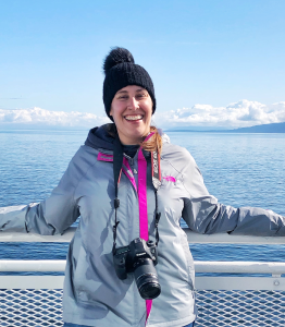
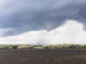
When Jenny Hagan was seven years old, she was playing in a tent one summer day in her backyard in Wadena, Sask., when a sudden downburst picked up the tent and hurled it against the fence with Hagan still inside. Hagan was unhurt, but the experience galvanized a lifelong interest in storms. “I stepped out of the tent, and there were trees flying, and trampolines,” she recalls. “And I just remember thinking, this is the coolest thing.”
When Hagan was 12, the family moved west, closer to the Alberta border. In the summer, storms would often boil up over the wide-open prairie, the clouds spiralling into enormous ragged towers lit from within by an eerie green glow. Hagan would bike down to the end of the road to watch the clouds twist and churn. As soon as she got her driver’s licence, she started following storms in the car to learn how they moved and the signs that a tornado could be imminent.
Now a healthcare worker and mother of two living in Eatonia, Sask., a town of fewer than 500 people about 250 kilometres southwest of Saskatoon, Hagan drives thousands of kilometres every summer in pursuit of storms. She is a “supercontributor” to the Northern Tornadoes Project — a coveted designation among the storm-chasing community that confers on the bearer a Northern Tornadoes Project ball cap and bragging rights about the number of reports they’ve supplied to the project. In 2022 alone, Hagan logged tornadoes at Foam Lake, Paynton and Cymric, Sask., as well as Sundre, Alta. At Cymric, the one storm spawned four different tornadoes over the course of its lifespan, and Hagan stayed behind to survey the damage on behalf of the project.

Hagan is happy to contribute to the scientific record of tornadoes in Canada, but like most amateur weather spotters in Canada, she chases for the thrill of it. It’s not the non-stop adrenaline rush depicted in Twister, the 1996 disaster epic that inspired a generation of chasers. “You’re doing a lot of sitting and waiting under blue skies,” she says. But a mixture of emotions takes hold when the skies darken and a violently spinning column of wind descends from the clouds. “There’s excitement that you nailed the forecast and got to the right area, but there’s also a little bit of dread. If [the tornado] is in a wide-open field, I can just enjoy the beauty of what Mother Nature has created. But as soon as it starts hitting structures, your heart sinks, and you’re just waiting for it to lift so you can go make sure everyone’s okay.”
In her many years of chasing, Hagan has witnessed the full panoply of nature’s fury, from a highway littered with thousands of frogs in the wake of a tornado in Manitoba to a lightning strike so close she felt the heat on her face. But she abides by the unwritten rule of chasing: when a tornado strikes a settlement, the chase is over, and the spectators become first responders. Some are trained to administer first aid, but often, storm victims just want to talk to somebody about what they’ve experienced. While chasing the Sundre, Alta., tornado, Hagan encountered a woman and her elderly mother who had fled their farm when the warning was issued. They were shaken by the close call and worried about a dog that had been loose on the property. Hagan listened to their story and reassured them that from her vantage point, the tornado had just grazed the farm. Later, the pair messaged Hagan to say the dog had been found safe. “If I can do anything to ease the trauma of what’s going on in front of them, then that makes me feel good,” Hagan says.

When Dave Sills was developing his original tornado climatology, he ran a statistical analysis using lightning data that suggested the southern Prairies, where Hagan lives, should be ground zero for tornadoes. But in recent years, that assumption hasn’t held up. In fact, in 2021, the Prairies saw just four tornadoes between mid-June and mid-August — a void that is “probably unprecedented” in the historical record, according to Sills. The reasons for the abnormally quiet season are still unclear, but Sills has some theories, including the ongoing drought in the Prairies and the presence of wildfire smoke aloft, which blocks the solar radiation needed to spark thunderstorms.
From late June to early July that same year, western Canada baked under a record-smashing heat dome. Under the dome, high pressure and blue skies prevailed, but along its northern edge, “ridge runner” storms laid waste to hectares of boreal forest in northern B.C. and Alberta.
The answer to the question of how climate change will impact the incidence of tornadoes in Canada is complicated to say the least. Longer periods of drought and more frequent and intense wildfires could dramatically reduce the number of tornadoes in the West, while increased incidences of heat domes at northerly latitudes could produce more damaging wind events at the fringes of the dome (the 2022 Ontario derecho formed on the northern edge of a heat dome).
Sills now has enough data for Ontario to point to other trends: big tornadoes, of EF-2 strength and higher, are happening later in the season, and tornadoes seem to be occurring more frequently in outbreaks. However, the connection between these trends and climate change is still unclear, not least because our basic understanding of the climatology of tornadoes in Canada is changing as the Northern Tornadoes Project uncovers more events in the northern forests. Sills acknowledges that this is frustrating for people who desire a clear-cut assessment of the risk of severe weather.
“It’s like, ‘How are we supposed to make any sense of this?’ But we actually have a better sense of what’s going on now,” he says. “Climate isn’t one event. It’s years and years of events. Basically, only in [Ontario] do we have enough data to string together a 100- year record and say something is statistically significant. There’s so much work to be done.”


On a drizzly, blustery January day, about as far removed from storm season as it’s possible to get, research architect Kimberley Adamek kneels on the plywood floor of Western University’s WindEEE dome and turns on a dry ice machine. White smoke billows up toward a gaping vent in the ceiling, then, shaped by the invisible force of 106 fans arrayed around the circular room, organizes into a spinning column: a small, stationary tornado controlled by computers in an adjacent lab.
In the realm of severe weather research, this is where the rubber meets the road. About 60 per cent of insured losses in the interior of North America are caused by localized wind events (read: tornadoes and downbursts), so WindEEE — which stands for Wind Engineering, Energy and Environment — was established in 2011 to advance the development of more resilient infrastructure.

“We advocate for safe houses — something that, if possible, can withstand extreme storms, or if not, something that can rebound quickly and does not compromise on the safety of the public,” says Girma Bitsuamlak, director of the WindEEE Research Institute, which encompasses Western’s three wind engineering laboratories.
Inside the WindEEE dome, scale models of various structures, from houses to transmission lines, are subjected to simulated wind events, often based on real data collected in the field by storm chasers and Northern Tornadoes Project researchers. Pressure sensors measure the wind load on the structures, and based on the results of the simulation, researchers can recommend changes to a structure’s design. When an EF-3 tornado struck Dunrobin, west of Ottawa, in 2018, destroying several homes, Bitsuamlak made a presentation to homeowners to help inform the community’s rebuilding efforts, and later tested a model of the affected neighbourhood in the WindEEE dome. Ideally, he says, safeguards against potential tornadic activity would be incorporated into every building code in the country, but currently, “There is a gap between what we know and what the industry practices.”
In the realm of severe weather research, this is where the rubber meets the road. About 60 per cent of insured losses in the interior of North America are caused by localized wind events.
Greg Kopp agrees. In 2021, after an EF-2 tornado struck Barrie, Ont., Kopp tweeted two photos showing what he called “preventable” damage to relatively new homes. “Missing roof-to-wall connections (nails) allowed a roof to slide off the walls of this house,” he said. “This is an issue of construction quality and does not meet the building code.” Reaction to the tweet was swift and outraged. Kopp gave dozens of interviews to local media the following day, calling on the provincial government to update its building code to require hurricane straps in new builds. Small, inexpensive pieces of hardware, hurricane straps reinforce the connection between a home’s roof truss and the walls and can dramatically reduce the likelihood of the roof coming off the building, even in tornadic winds up to EF-2 strength. Currently, no provincial or territorial building code requires the use of hurricane straps in new builds, though Kopp and others, including the City of Barrie, have submitted a code-change request to the Ontario Ministry of Housing and Municipal Affairs.
What happened in Barrie, where the most severely damaged homes weren’t even built to the minimum standard required by the current code, was “a life safety issue,” says Kopp. “That’s where I think government policy matters on this. Builders will be very good at finding the least expensive way to meet the code, so we need standards that set that level appropriately.’’

As I write this, it’s coming up on a year since the derecho hit Ottawa. The Saikaleys have repaired their roof, though they did not replace the skylight that was torn out. Outside of the city’s broken forests, little evidence remains of the storm’s wrath — a strip of yellow caution tape knotted around the post of the traffic-calming sign at the entrance to the Saikaleys’ street; a metal shed still lying, crushed, where it was blown into the corner of someone’s yard.
Salwa Saikaley thinks back to that day and how lucky they were: that her children and grandchildren got home safe, despite their car nearly being crushed by a fallen tree; that the winds did not directly strike the sunroom where Toufic was resting; that nobody they loved was injured or killed. She stares reflectively into her coffee mug. “I just hope it doesn’t happen again,” she says.

This story is from the July/August 2023 Issue
Science & Tech
Alberta-based computer scientist Mark Simpson can design anything he puts his mind to. So why has he chosen to chase tornadoes?
Science & Tech
Physical distancing requirements to slow the spread of COVID-19 will make it difficult for researchers to visit suspected tornado sites this year, so the team behind the Northern Tornadoes Project is calling on the public to help

Environment
Program used community reports and remote sensing to confirm tornadoes

Environment
Weather: a classic conversation starter with the potential to unite a community in either elation or in shared laments.