People & Culture
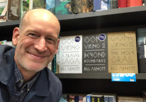
Gone Viking with Bill Arnott
Episode 83
Bestselling author Bill Arnott discusses his work as a writer tracing the voyages of Vikings around the world
- 32 minutes
Places
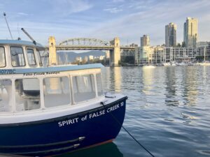
Bestselling author Bill Arnott takes readers for an exploratory stroll along Vancouver’s beloved beachside of Kitsilano as part of his new book, A Perfect Day for a Walk


The crows are in flight, reminders of omens and overcast skies. But this day is different, a horizon layered in gold as the birds start their day, crossing Vancouver from rookery homes in cottonwood trees, flying to parkland and seashore. I can gauge the day, I believe, in their flight. With a glance out a window at sunrise. Are the crows flying high? Flying low? Flapping and tacking or gliding in ruler-straight lines? And no, I won’t say “as the crow flies.” Too obvious. Plus, I’ve seen them weave in meandering updrafts emitted by blacktop, curving roadway the same as their flight path.
Beyond the black corvids, their very presence a measure of space and time, this is about Vancouver. A place that I love because and in spite of its makeup. Visual beauty and grit, history as multilayered as anywhere, all of it nestled in mountains, cuddled by sea. A high-rise pincushion of steel and glass needles, tucked between bodies of water. Or rather, a single saltwater body with a great many arms, a Kraken embracing the metropolis, giving an extra good squeeze. The city motto? By sea land and air we prosper. Although needing punctuation, the message is clear, a blend of optimism and aspiration. This is indeed a prosperous centre, abundant yet rife with lack. In other words, a city. Thriving, striving, surviving, a conglomerate of culture and hope.

A few facts to start. Vancouver is one of the country’s most diverse cities, with English not being the first language of half the population. Most of its residents are what the government of Canada labels “visible minorities.” Which is laughable and, at best, ethnocentric. When a majority is deemed in minority. In other words, not white. While this sprawl of humanity continues to rank as one of the world’s most livable cities, as well as being one of the most expensive.
Search the city, online or in person, and what you find tends to loop, descriptors repeating in soundbites and slogans: scenic views, mild climate, unparalleled natural beauty, ocean and mountains and living outdoors. An online snippet I read poses the seemingly simple question, “Is Vancouver a good or bad city?” One reply makes me smile. “Yes, it is.” While another answer offers much more. “It’s a lovely city, one of the world’s most beautiful, provided you can afford to enjoy it.” And therein lies a rub. The rub, perhaps. One of an endless array of puzzles and queries surrounding the city of Vancouver.
I’ve lived here for almost four decades. It’s my home here on Musqueam, Squamish, and Tsleil-Waututh land. And while I’ve lived in many of its neighbourhoods, much of it will forever feel new. Not merely new buildings but a recurring burble of the unfamiliar, fuelling a sense of discovery each time I step out the front door, as though I’m a tourist, explorer, or adventurer. Here, where I live and I work.
Exploration and discovery, however, unveil further questions. What exactly am I seeing out there? Who made it like this? Why’s it this way? And what will it be like tomorrow? Questions that drive me to examine this city, needing to better comprehend its “sea, land and air,” scenic views and natural beauty. Something I’m doing on foot.
I could rattle off quotes about the imperativeness of walking to truly experience a place, but that’s neither fair nor accurate. A bus or a train may accomplish the very same thing. Mobility might vary. But for me, feet and legs are a preferred mode of transport. Rousseau stated he could only think when he walked. A part of me feels the same way. While novelist Flann O’Brien claimed every step we take actually infuses some of the paths that we travel, an ingestion of places we wander. So for now, I’ll be walking, slowing my pace to better absorb this city, see what questions I answer and what else I reveal. Here in Vancouver, my home.
The morning brightens as I make my way north into Kits, or Kitsilano, named for Squamish chief August Jack Khatsahlano. Passing the retail of West Fourth Avenue, I walk a few blocks to the mouth of False Creek, past the Maritime Museum of Vancouver, where a leafy deciduous houses a bald eagle’s nest. The twig-and-stick home was moved a few years ago, having served generations of bald eagles where it perched in Vanier Park’s highest tree, a towering poplar. According to local birders, a breeding pair also lived under the Granville Street Bridge, like two feathered trolls, but all I’ve ever seen in those high metal rafters are pigeons and cormorants.

Dogs are barking and splashing along Hadden Beach, a sandy off-leash space I can’t help but see as an oceanside litter box. We should be so lucky to have such a view from our toilets. But the furry friends are having a fine morning, every owner staring at the water. And I leave them all to it, chewing on sticks and dreaming of life at sea.
Following the path’s curl, I walk to the end of a finger of rock—Elsje Point—the promontory offering a panorama of the city and inlet. At the end of the point, an anchor is chained to the ground, as though this slim spit of land is being held in place, kept from drifting to sea.
I trudge over grass to the Ben Franklin submersible that fronts the Maritime Museum. Something about it screams Jules Verne and a whole bunch of leagues undersea. The craft, a steel sausage in yellow and white, looks like a squat submarine, but I learn that submarines are longer-voyage vessels, while submersibles usually have additional ship support. This leaves us to imagine what the view might be like peering through portholes deep in an undersea trench.
But this craft did have a crew and undertook a remarkable journey. Not quite twenty-thousand leagues, but still advanced for its time. Built in 1968, its role was to explore and research the Gulf Stream, the Atlantic current first charted in 1770 by Benjamin Franklin, thus the ship’s name. The submersible’s maiden voyage was from Florida to Halifax in the Summer of 1969. Yes, Summer of ’69. It’s song-worthy for sure, but it’s tough to find lyrics that rhyme with submersible.
Notably, the Ben Franklin expedition was of interest to NASA, far beyond the data being gathered by the underwater team. The space agency was eager to know how a team of scientists would adapt and endure a month-long voyage in a cramped workspace with sensory deprivation. Information NASA wanted as a crewed mission to Mars was being planned. Still is, in fact. With the same Ben Franklin data gathered then being used to this day.
The submersible’s expedition went well, the craft arriving in Halifax a month after bobbing out of Florida. The news of the Ben Franklin success, however, evaporated almost immediately as Apollo 11 made its historic moon-landing at the very same time. Now, as I circle the vessel, a trace of that silvery moon is fading in chalky blue sky, still snubbing this sea-salted ship.
With the show-stealing moon almost gone, I carry on, my view now a wispy cloud sky with the art deco loom of Burrard Bridge. For bridge connoisseurs, this one’s three spans with two truss types. A Pratt truss for the high mid-section boats pass beneath, and Warren trusses on the close-approach span, that is, the end bits. Four concrete towers hold it in place, while two galleries connect both the northern and southern towers. From these, two ornamental ship prows protrude. One was topped by a bust of Sir Harry Burrard-Neale, the other a likeness of Captain George Vancouver, with each sporting a respective initial: B and V.

The bridge now overhangs the Sen̓áḵw construction site. At present, “the largest First Nations economic development project in Canadian history.” An expansive initiative slated for multiple towers and a few thousand new homes. According to its builders, Sen̓áḵw translates to “the place inside the head of False Creek,” literally placing it on the map. On the south side of the bridge, just east of its trusses and towers, for years, I would pass two cedar carvings, no longer here. Tall totems depicting traditional Salish greetings of welcome, known as O’Siem, with palms held open, inward, and up. It’s an expression of gratitude, too. Fitting in this coastal enclave, the inlet narrows to False Creek, a watery entrance to the city.
No one seems to know where the totemic statues have gone. Maybe they wandered off, tired of the noise of construction. But the site will be a version of this for a decade, with cranes surrounding the bridge, the look of new towers, latticed trusses in red-painted steel. The ground, too, is being reborn, construction rising from plummeting pits. Here the land is clay over sandstone and shale. A bit north, we’d hit granite, the metamorphic coastal expanse, igneous rock from bygone volcanoes.
I find a series of plaques, Places That Matter, Vancouver Heritage Foundation installations I could use to plot a course across the city, a trail of breadcrumbs through time. According to Musqueam First Nation historians:
The area now known as Burrard Inlet is host to numerous Musqueam villages, camps, and transformer sites. It was connected by water ways, trails, histories, and genealogies to other villages throughout our territory. Burrard Inlet was also part of our core hunting and fishing area. Our families stayed here while hunting elk and waterfowl. Sən̓aʔqʷ (Sen̓áḵw) was also important for harvesting and processing salmon, sturgeon, and smelt that frequented False Creek and its many streams, many of which have been lost to urbanization and development.
The notion of historical trails, that infusion of paths that we travel, lingers as I deviate to another spur path, tamped by a few thousand feet, what would have been shaded by totems now a small arboretum. Cultural Harmony Grove. The name alone inducing a peacefulness. My pace slows as I weave between trees. Cedar and maple, crabapple, windmill palms, even a monkey puzzle tree, stretching and poking the sky. There’s dogwood and birch, foxglove and snowbell. Names that rattle into a poem. I retrace my steps and recite the flora, concocting a potion or spell. All I need is eye-of-newt for something a wizard might conjure.
By the pocket of park a sign warns of coyotes next to a palm tree, a small gnarly spruce, and the buttressed wood-end to what was a rail- and trolley-car bridge. A pair of crows have alighted where the two totems stood, leaving me to wonder if they’re related, placeholders perhaps, standing guard until the totems return.
The white noise of traffic hums from the bridge, a moan of trusses and towers. Underneath are rock reinforcements in gabion wire. I’ve retraced my steps, westbound, past a Coast Guard station. Which was here, then it wasn’t, now it’s back. Different budgets and electoral promises.
Through a corridor of poplar and beech, an extension is being added to a pier, a crane hoisting huge slabs into place. Behind me, a transition of Vanier Park outdoor events. The Bard on the Beach Shakespeare Festival happens here in the summer: tented marquees, flapping flags with bunting and spinnaker, the feel of a medieval fete.

The bay and the inlet are busy with commerce, anchored ships awaiting their turn at the port. A songbird skitters through rocks at the shore, where a boulder is topped with cleanly-scraped clamshells. Diners done with their feast, the rock now an avian midden.
There’s a heady aroma of leaves, paired with the essence of sea. Behind me are the Museum of Vancouver and H.R. MacMillan Space Centre, a short stroll from the Maritime Museum with its Beatle-esque yellow submarine. Sorry, submersible. I size up the ships in the bay. Tankers, bulkers, freighters. Some empty, some full. Waterlines telling their tale, like long distance trucks at a weigh-scale. Their profile an indicator of what each ship carries. Goods in containers, fuel in tankers, ore in bulkers, ships with customized cranes to haul lumber. By sea land and air we prosper. And I think of a quote from reporter Tom Zoellner. “If you want to understand the soul of a city, look at the economic reasons for its founding.”
The paddle and flap of a few waterbirds melds with the seagulls and crows. Cormorants, scaups and mallards. Two geese fly away in a futile attempt at a vee. Overhead, ducks flying west are shifting through letters: U, W, J, their flightpath a tentative cursive. A high-pitched hum, a near-whine, as two buffleheads pass. A pintail swallows a wriggling fish, silver flashes as the fingerling thrashes. Behind me, footprints traipse through lush grass.
I pause on the south side of Hadden Park, where the Centennial Totem Pole stood before removal for restoration. Carved by Kwakwaka’wakw artist Chief Mungo Martin with his son David Martin and his nephew Henry Hunt, it was raised in 1958, a cultural beacon and landmark. A kind of sundial gnomon as well, one measuring time immemorial.
Veering to the low rise of Vanier Park, my route circles into a spiral, this gusty point of land a favourite for kite-flyers. On the soft promontory is a massive steel sculpture, the outline of a square, but a square with a pried-open base. From a side, the installation resembles a walker, striding the grass, geometry mid-stroll. The sculpture Gate to the Northwest Passage was constructed in 1980 by Alan Chung Hung. It’s a beast, over four-and-a-half metres on each side, the split lower portion resembling a splayed paperclip. The result, a blocky square arch, designed to commemorate Captain George Vancouver coming here in the summer of 1792, arriving in his ship HMS Discovery along with the HMS Chatham. Harry Burrard-Neale was the Captain’s colleague and friend, the two initialled on the multi-trussed bridge beyond.
By gazing through the square of the sculpture, any angle, you can’t help but see it as a photo or window. A director previewing a scene, holding index fingers and thumbs in an outline, getting a mood into frame. Once again I circle the installation, admire its clean simple shape, soft corrosion of steel, with a knife of discomfort, knowing the results of that empiric exploration. Decimation following the “discovery race,” a grisly wake trailing those vessels. I consider the carvings of welcome, once by the bridge, now moved on, same as the Centennial Totem. Another stab of unease, until I see the new growth of Sen̓áḵw, land carved and shaped now in brilliant sun. And with it, a slice of renewal.
People & Culture
Bestselling author Bill Arnott discusses his work as a writer tracing the voyages of Vikings around the world
People & Culture
In his latest book, best-selling author Bill Arnott takes readers on a stroll along the shores of Vancouver while providing personal insights into the city’s history

Travel
A local’s guide to one of Vancouver’s most iconic neighbourhoods

Mapping
Brian Grant Duff from All Nations Stamp and Coin explains the controversial land claim made by Irish settler Sam Greer on what is today known as Kits Beach