History
Lake Winnipeg watershed: then and now
In 2006, Allan Casey wrote about Lake Winnipeg in Canadian…
- 448 words
- 2 minutes
This article is over 5 years old and may contain outdated information.
Environment
How the watershed connects the Prairies and its people
“There is no distinction between the water that flows down our drains and the water that flows through the lakes and rivers of the Prairies,” says Alexis Kanu, executive director of the Lake Winnipeg Foundation. “It’s water that connects all of us in the Prairie provinces.”
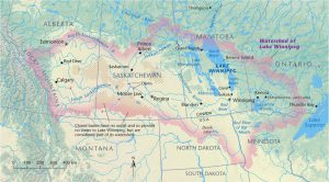
This is quite literally true. Rain and meltwater pouring out of the Rocky Mountains and flowing east through Calgary or Edmonton on the Bow and North Saskatchewan rivers — and perhaps through city plumbing before it exits the cities — can reach Lake Winnipeg, more than 1,800 kilometres away, in as little as two to three weeks. After that it moves north, ultimately mixing with the salt water of Hudson Bay.
The whole dynamic system is called the Lake Winnipeg watershed. It’s one of the world’s largest drainage basins, home to about seven million people and about the size of Spain and Sweden combined.
Kanu says Lake Winnipeg’s symptoms of recent years — algae blooms, beach closures, drinking water advisories and so on — indicate that many of the waterways leading to it are under strain. And because they originate in parts of Ontario, Manitoba, Saskatchewan, Alberta, Minnesota and North Dakota, it’s a problem that needs an international solution.
One crucial part of that solution is education. The map above for example, is part of a multi-year initiative called OPEN Water, which was designed to introduce the concept of watersheds as geographical boundaries (similar to ecozones or political borders) to K-12 students in Canada and the United States. Spearheaded by Canadian Geographic Education, the North Dakota Geographic Alliance and the Minnesota Alliance for Geographic Education, OPEN Water is a framework for learning about everything from invasive species to how human activities in Minot, North Dakota, or Calgary can affect the lives of people who depend on the same water several hundred kilometres away.
Through lesson plans and a large-scale “tiled” version of this map (funded by the Lake Winnipeg Foundation), soon available for downloading and printing, students can learn about the whole watershed in their classroom and then go out into the field to take part in hands-on citizen science.
Visit Canadian Geographic Education for lesson plans and to download and print the tiled map of the Lake Winnipeg watershed.
History
In 2006, Allan Casey wrote about Lake Winnipeg in Canadian…
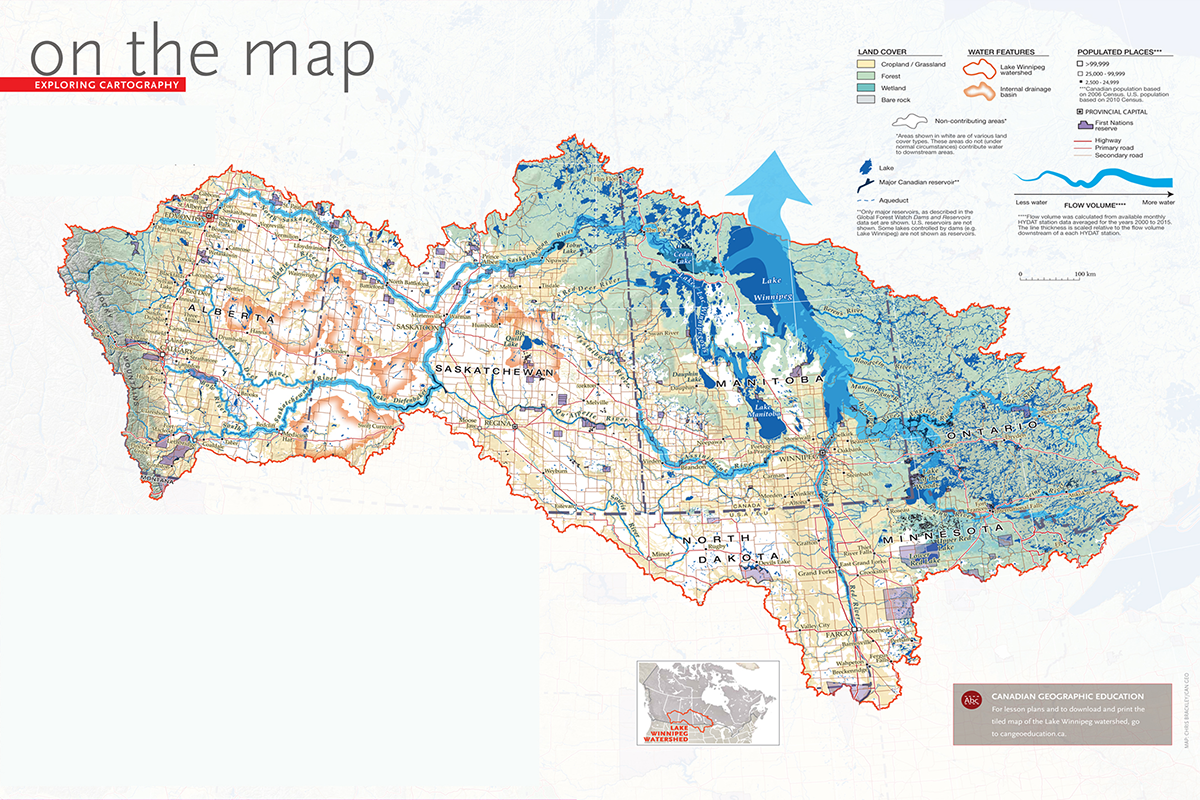
Wildlife
Lake sturgeon populations have plummeted in the Great Lakes watershed. Here’s how First Nations are collaborating with scientists to save an ancient relative.

Environment
An agreement with the government says nations can move forward with feasibility study for new Indigenous Protected and Conserved Area in the Seal River watershed
Environment
Many of Canada’s 25 watersheds are under threat from pollution, habitat degradation, water overuse and invasive species