People & Culture
Kahkiihtwaam ee-pee-kiiweehtataahk: Bringing it back home again
The story of how a critically endangered Indigenous language can be saved
- 6310 words
- 26 minutes
This article is over 5 years old and may contain outdated information.
People & Culture

Fair winds took us from Greenland around the last remaining pack ice in Baffin Bay and into Canadian waters. We had not yet decided on a route since cloud cover over the Canadian Arctic cluttered up the satellite images. /p>
To bide our time and get further information on the ice situation and where to see walruses and narwhals we decided to go to Grise Fiord, Canada’s northernmost settlement. So we sailed to reach the small hamlet across Jones Sound, an area that had been covered with pack ice just two weeks before.
From a distance we could see the small village of no more than 50 houses and a few large fuel tanks. We dropped our anchor and were welcomed by two curious children in a kayak, who told us that there were lots of narwhals around at the moment but no signs of walruses.
Later that day our boat was surrounded by close to 100 narwhals, but we weren’t aware of the fact until a shot rang out and we witnessed the life and death struggle of a hunted narwhal.
While rowing in our dinghy toward the shore where people had gathered to see the whale being pulled in, we saw a strange shape moving in the red water around the whale. It was a three-metre long Greenland shark, an extremely rare find that created a lot of excitement both on the shore and in the dinghy.
Back at the boat we pored over satellite images, ice charts and weather reports to see which of our planned routes showed signs of ice clearing. The ice charts indicated dramatic melting all over the Arctic this year as we anticipated, but despite this both our planned routes remained partially sealed. We knew that we may have to wait a week or more before one or both of the routes opened, or we would have to abandon them.
In the end, we chose to attempt the larger and more technical McClure route rather than North of Devon route, and left Grise Fiord to sail the 400 nautical miles to the next staging point in Resolute. If the route is still partially open when we arrive we will attempt to squeeze into the small channel we saw appear on the satellite images and hope that while we are pushing through, the rest of the passage will clear before the ice closes in once again for the long Arctic winter.
Plying through the northern waters of Jones sound, surrounded by the glaciers and fiords that lined the coasts of Ellesmere and Devon islands, one could not help but think of the major expeditions that passed through here, and which once marked the furthest navigable point by sea. William Baffin first saw and named Jones Sound from afar in 1616 but it wasn’t until 300 years later at the turn of the 20th century that Jones Sound would be explored.
Norwegian Otto Sverdrup headed the exploration of Jones Sound, which led to the discovery of so many islands that it surmounted the total number that the Franklin expedition and its subsequent search parties would discover. So thoroughly did Sverdrup survey the area under the Norwegian flag that the Dominion of Canada paid him $67,000 for all his maps, notes, diaries and other related documents and coincidentally, at the same time Norway formally confirmed Canada’s title to the islands.
From Jones Sound we rounded Devon Island and tracked the southern coast, spotting seals and walruses, until we reached Beechey island and dropped anchor in Terror and Erebus Bay where Franklin’s mysterious expedition wintered before disappearing forever. The island, while quite bleak and windswept, contains Franklin’s cairn and the bodies of three of his crew which remain covered in rocks on top of the permafrost.
It was remarkable to walk the shale beach of the island and imagine the bay as men prepared their supplies and ships for a long winter. The entire expedition embodied the spirit of exploration: to discover a Northwest Passage through a frozen world that had never been mapped.
We explored the area visiting the graves, the old cairns and platforms where the crew had erected small buildings. Signs of their living on the island were apparent but scarce; we found parts of old barrels but none of the famous lead-lined cans that are thought to have helped seal the fate of the missing expedition.
We sailed the next morning in heavy snow for Resolute. It somehow seemed like a fitting way to depart the historic island.
Are you passionate about Canadian geography?
You can support Canadian Geographic in 3 ways:
People & Culture
The story of how a critically endangered Indigenous language can be saved
People & Culture
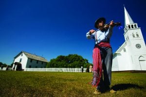
“We were tired of hiding behind trees.” The ebb and flow of Métis history as it has unfolded on Ontario’s shores
Exploration
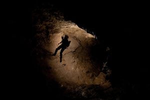
Caving: The ultimate underground sport
Wildlife
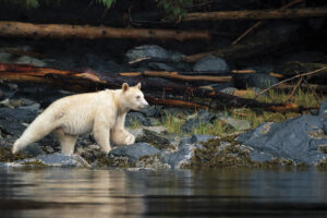
How ‘maas ol, the spirit bear, connects us to the last glacial maximum of the Pacific Northwest