
Wildlife
Moonlight drives zooplankton migration in Arctic winter
A new study finds even in the dead of winter, zooplankton flee the light of the moon.
- 351 words
- 2 minutes
Travel
The nation’s coolest road trips — literally

The onset of cold and snow shouldn’t spell the end of road tripping for the coming months. The lines of motorists that would slow your roll through resort towns and on the highways to cottage country in the summer may be in hibernation, but the routes themselves — from Newfoundland’s Viking Trail to the B.C.-Yukon border-traversing Alaska Highway — never quit.
But they are transformed. Rolling white Prairies become almost hypnotically beautiful, mountains are crusted in snow, and the wild seas along the West Coast will drop your jaw. All cold-weather travel takes is a little bit of extra planning and a readiness to brush with the unexpected, so check the long-term forecast, throw a well-stocked safety kit in the trunk, give your winter tires a kick and set out on one of the seven spectacular winter road trips featured here.


Not for the faint of heart, Newfoundland’s Viking Trail is the spinal cord for the string of small towns dotting the island’s Great Northern Peninsula.
Route 430 winds north from Deer Lake, carrying goods to towns with names such as Sally’s Cove and Quirpon (pronounced car-poon), and with an onshore wind in winter, snow can arrive at any moment.
If you really need to stretch your legs (and lungs), stop your transit of the trail in Gros Morne National Park, where there are 50 kilometres of groomed cross-country ski trails.
Refuel yourself back in Deer Lake or move on to Norris Point or Rocky Harbour; all three towns traditionally stagger their winter carnivals from mid-February through to early March, and if your timing is good, moose soup, chili, meatballs and shepherd’s pie could be on the menu.
And not just on the menu. Moose (and caribou, closer to the northern end of the route) are a common sight, with the former frequent enough to be a serious road hazard for the unwary.
Sights on this portion of the trail include the small, bright huddle of shoreline houses on open ground in Green Island Cove, the Flower’s Cove lighthouse (which is so tantalizingly close it appears you can almost touch it, but is actually ensconced on a small harbour island) and, near the top of the peninsula, the sheltered bowl of St. Anthony Harbour.
And finally, if you can make it, Burnt Cape, a limestone cape of broken stone so barren and windswept you would swear you had turned north and found the Arctic.
—Russell Wangersky
Distance: 418 kilometres
Don’t miss: A detour down Route 431, which will bring you to the Tablelands. In winter sun, it’s a sight so stark you’ll shiver no matter how well dressed you are.
Soundtrack: The albums Honey for Bees or Sun Gets in Your Eyes, both by western Newfoundland’s Sherman Downey and the Ambiguous Case.

It might be a stretch to call it the Powder Highway of the East. But set out from Montreal on Autoroute 10 E, and sooner than you can say “black diamond” you’ve left behind flat farm fields and hit enough contour lines to guarantee a good day on the slopes. Consider the highway to the Eastern Townships, a hill-studded swath between the St. Lawrence River and the U.S. border just east of the country’s second-largest city, your season ticket — or weekend pass — to the closest you might get to reaching skiing Nirvana this side of the Rockies.
Start your weekend by heading out right after office hours for a few Friday happy hours in the snow. At Bromont, only 50 minutes from Montreal, 99 of the 143 groomed runs are lit until midnight, making it the resort with the biggest night skiing terrain in North America.
On Saturday, leave the party scene behind and ease into nature. Meandering between maple- and spruce-draped hills, the half-hour drive south along Route 241 and 139 drops you at the foot of Mont Sutton. If you’re the sporty type, you slap fake mohair skins on your skis and make your way to the summit on your own steam before dropping in to what some people argue is the best glade skiing experience in the country.
For a more mellow ride, head a bit farther east to Mont Orford. Rated a good beginner mountain with more than howlalf of its trails green or blue, it boasts the highest summit — and some of the best views — in the region. And at nearby Owl’s Head, where the top elevation gives you a panorama of lakes and hills, 70 per cent of the runs are beginner or intermediate.
If the promise of speeding down the slopes isn’t enough to convince you to make the trip, perhaps the region’s après-ski offerings will whet your appetite. Some 60 per cent of Quebec’s wines, including the province’s first chardonnay, are made here. And of course, along with the wine comes food pairings from forward-thinking farmers and artisanal bakers, butchers, cheese makers and chocolatiers, not to mention the most inventive of beers, offering plenty of reasons to toss a coin as to who in your party will be the designated driver.
—Susan Nerberg
Distance: 93 kilometres to Bromont, 115 to Sutton, 128 to Orford, 144 to Mansonville (Owl’s Head)
Don’t miss: Balnea, a thermal spa with steam and dry saunas and hot tubs close to Bromont, for soothing ski-sore muscles or warming up after a day of playing outside.
Soundtrack: Coeur de Pirate on the way to the hills; Jean Leloup before hitting the slopes; Leonard Cohen for the drive back to Montreal.


When a highway starts off with more bumper views than escarpment vistas, it may require a few deep-breath ohms to get you on your way. But a wintertime journey from Toronto to the Niagara region is no less worthy of the road-trip moniker: the cosy car, the playlist, the getaway!
As you follow the QEW and the urban spread of the Greater Toronto Area toward the industrial skyline of Hamilton and the Burlington Skyway bridge, the relief of the regional roads and more intimate Lake Ontario moments are not far off.
Plus, country calm awaits: local dinners with wine or craft beer pairings, cosy inns with fireplaces and seasonal events from the Shaw Festival’s A Christmas Carol (December) to the Niagara Falls Winter Festival of Lights. The Niagara Peninsula’s big cold weather draw, however, is the icewine festivities that take over the January weekend calendar to celebrate that sweet fruit of the winter vine. Twenty Valley is home to the artsy Winter WineFest in Jordan Village, and Niagara-on-the-Lake takes the party outside with its long-running Icewine Festival.
A Niagara Icewine Festival Discovery Pass also allows you to pick and choose wine-and-culinary matchups at participating wineries over three weekends. And it’s here, while travelling country roads past frozen fields toward warmly-lit converted barns or tasting rooms with grand vistas of the Niagara Escarpment, that you’ll get the reward that only the very best road trips can offer: your next stop unknown but no less anticipated.
— Karen Smith

Distance: 130 kilometres
Soundtrack: Sample southern Ontario talent such as Whitehorse and the Strumbellas, or try some Royal Wood, a singer-songwriter-sommelier-in-training.


You aren’t alone if you think the snow-dusted hay bales found along the wide-open Saskatchewan prairie in winter resemble giant Frosted Mini-Wheats. But these breakfast-cereal-confection look-alikes are just part of the appeal of driving a route that offers a glimpse of First Nations and Métis history, Francophone farming communities and a national park, not to mention the experience of seeing the seemingly endless prairiescape metamorphose into an enticing playground of snow-laden grasslands, rolling aspen parkland and boreal forest dotted with frozen lakes.
Start your journey just outside Saskatoon at Wanuskewin Heritage Park, a meeting place for First Nations people for more than 6,000 years. The park’s enriching programming includes traditional Indigenous games, arts and crafts, exhibitions and tipi construction.
Continuing north on Highway 11, a.k.a. the Louis Riel Trail, detour east onto Highway 312 at Rosthern and cross the Gabriel Dumont Bridge, which spans the South Saskatchewan River, and enter the Batoche region. Highway 225 will lead you north to Batoche National Historic Site, where a small force under the command of Métis leaders Riel and Dumont lost the Battle of Batoche in 1885.
When Highway 225 meets Highway 782, head east along the former route, making for the Francophone farming community of St. Isidore-de-Bellevue, where you can sample a traditional meat pie at the TLC Cafe.
From there, it’s north on Highway 2 to the city of Prince Albert, the gateway to Prince Albert National Park. Once inside the park, watch for wildlife (Narrows Road, on the western side of Waskesiu Lake, is a prime spot for sightings) such as elk, fox and otters. You might also see wildlife while snowshoeing around the hamlet of Waskesiu Lake’s beach area or cross-country skiing the groomed pathways along Fisher Trail (loops of 7.2 and 8.4 kilometres) or Crean Lake (19 kilometres return).
If this all sounds a tad too placid for you, then get a major adrenaline boost kite skiing or kite boarding on Waskesiu Lake, where Saskatchewan’s notoriously fierce winds will see you catch some serious air.
Before returning to Saskatoon, stop at the Elk Ridge Resort (off Highway 264 and just outside the park’s boundary) for dinner at the Fireside Dining Room and Terrace, where the elk feature of the day will give you all the fuel you need for the gorgeous drive ahead.
—Jenn Smith-Nelson
Distance: 230 kilometres
Don’t miss: Posing next to what has to be the ultimate Saskatchewan roadside attraction: the giant stalk of wheat in Rosthern, where highways 11 and 312 meet.
Soundtrack: Keep warm with the smooth sounds of Saskatoon’s very own The Sheepdogs.

Winter in Alberta’s cowboy country is an amalgam of snow-dusted ranches and long views of the Rockies, buried deep in powder. Highway 22, a.k.a. the Cowboy Trail, traces the eastern edge of the foothills through rolling, open country. Compared with the province’s iconic 232-kilometre Icefields Parkway from Jasper to Banff, the road-trip vibe from Calgary to Waterton Lakes is intimate and off the beaten track — with far less traffic.
The 312-kilometre journey begins on the Trans-Canada Highway, westbound from Calgary. Exit south on Highway 22 and promptly dip into sprawling ranch lands. The distinctly Prairie towns of Turner Valley and Black Diamond owe their existence to oil and coal, respectively. Today, their broad, old-fashioned main streets have been reinvigorated by a new generation of western artists. Farther down the road, Canadian folk music legend Ian Tyson lives in Longview; it’s easy to see how the surrounding landscape (including the Bar U Ranch National Historic Site, which once hosted the Sundance Kid) inspired great songwriting.
Highway 22 merges into Highway 3 and peels away from the Rockies to Pincher Creek, where the winter Chinook winds funnel through the Oldman and Castle river valleys. A 60-kilometre drive south on Highway 6 takes you into Waterton Lakes National Park’s labyrinth of mountains. The so-called “Crown of the Continent” makes an alpine connection with Montana’s Glacier National Park.
The quaint village of Waterton is the gateway to a weekend of outdoor adventure. Stay at Waterton Lakes Lodge Resort, which offers free snowshoe and ski rentals, and hit the scenic Akamina Parkway, which affords access to two cross-country ski trails.
—Conor Mihell

Distance: 312 kilometres
Don’t miss: Located near Waterton village, Cameron Falls is the quintessential Waterton Lakes photo op; it’s even better when it’s sheathed in ice.
Soundtrack: Live at Longview by Ian Tyson. Your journey through cowboy country wouldn’t be complete without listening to this classic live album.

Driving the east coast of Vancouver Island from Nanaimo to Port Hardy on Highways 19 and 19A can take just four hours. But what’s the rush in the off-season, when heritage hamlets, locavore gems and surf-battered beaches beckon in Canada’s mildest winter region?
Nanaimo
Begin your journey in the island’s harbourfront second city, where the bookstores, coffee shops, music stores and art galleries lining Commercial Street invite leisurely exploration.
Rathtrevor Beach Provincial Park
The 19A passes small communities and Salish Sea bays. Stop at Rathtrevor’s driftwood-studded sands for beachcombing and skedaddling sea otter sightings.
Morningstar Farm, Parksville
Sidestep from the highway to visit this farm, home to the Little Qualicum Cheeseworks. They serve up generous samples (try the Bleu Claire) and also sell delectable, velvety blackberry wine from the on-site Mooberry Winery.
Cumberland
If you prefer beer over blackberry wine, stop in at the Cumberland Brewing Company for a pint. The old village’s hip storefronts invite further perusal, but skiing at Mount Washington is just 30 minutes away.
Telegraph Cove
Drive past Campbell River and detour via Beaver Cove Road to reach this scene-stealing charmer, where the brightly painted old buildings present the perfect photo op.
Alert Bay
Save your memory card for equally beguiling Alert Bay, a short ferry ride away from Port McNeill. Its boardwalk shacks and striking totems are joined by bald eagles whirling overhead.
Port Hardy
Explore the north’s main town, then make for Cape Scott Provincial Park. Its forest-fringed San Josef Bay beach is a dramatic, wave-whipped reminder of the raw beauty of winter travel.
—John Lee
Distance: 155 kilometres from Nanaimo to Campbell River, 230 from Campbell River to Port Hardy
Don’t miss: Alert Bay, a mist-shrouded waterfront village studded with incredible photo opportunities.
Soundtrack: The albums Mememe or Dream Water Rain Music, both by Corwin Fox, a roots-folk singer-songwriter who lives in Cumberland, B.C.


The best reason to travel the Alaska Highway in winter is the fact that few people do. Other than the occasional transport truck lugging fresh milk and vegetables to the Yukon and Alaska, or locals commuting between towns, traffic is sparse on this road from December through March, unless you count the moose. Gone are the oversized RVs that trawl the highway from Fort Nelson to Beaver Creek all summer. Closed are the tourist traps selling overpriced cinnamon buns along the way. What’s left is a world of wind, ice, spruce, and stars — so many you’ll suspect you’ve detoured into the Milky Way.
I’ll let you in on a secret. Those who live in the North generally don’t dissuade people of the notion that winter here is a cold dark perdition for good reason: we don’t want company. It’s nothing personal! And if you do come to northern British Columbia, Yukon or Alaska, rest assured that northerners are a welcoming bunch, whatever the season. We just selfishly prefer the Liard Hot Springs to ourselves on a –30 C night, when steam rising into the sky seems the source of the aurora borealis. We’d rather not elbow through crowds in Kluane National Park to watch herds of white-wooled Dall sheep blend into the snow, leaving only their dark curled horns visible on the slopes, like parings of wood adrift on the wind. We want to watch the
low-angled sun throw gorgeous amber light over the Saint Elias Mountains, the highest range in Canada, in a silence so total you can hear time itself crack.
Winter might be the off-season on the Alaska Highway, and that makes it all the better for a road trip. Just promise you’ll tell everyone how frigid and desolate a drive it was when you return home.
—Kate Harris
Distance: 1,395 kilometres
Don’t miss: Detouring off the Alaska Highway for a hundred spectacular kilometres to Atlin, B.C., a quirky, artistic outpost on the edge of the Juneau Icefield.
Soundtrack: Yukon-born Declan O’Donovan’s latest album, Broken Sky, features piano-driven music as moody, lyrical and expansive as the land in which this singer-songwriter was raised.

This article was originally published in the November 2017 issue of Canadian Geographic Travel.

This story is from the Canadian Geographic Travel: Fall 2017 Issue
Wildlife
A new study finds even in the dead of winter, zooplankton flee the light of the moon.
Travel
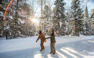
Skip the summer crowds and discover why this central Ontario town is just as iconic in the colder months
Environment
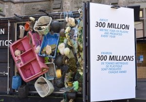
The interactive Ocean Plastics Lab is visiting Ottawa until Aug. 12

Wildlife
Meet the Goosinator