Mapping
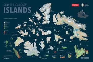
Mapping Canada’s 75 biggest islands
Canadian Geographic's cartographer Chris Brackley shares insights into his process in charting the country's largest islands for an exclusive wall map
- 1341 words
- 6 minutes
This article is over 5 years old and may contain outdated information.
Mapping


As Prince Edward Island prepares to celebrate the 250th year of Samuel Holland’s famous map of the province (shown above), Boyde Beck, the curator of history at the PEI Museum and Heritage Foundation, explains more about Holland and the cartographic work he did on the island.
On Holland’s life
He had such a fascinating life. He starts off in the Dutch army, but he didn’t study to be a surveyor or a cartographer; he was a military engineer, and making maps was a skill he had to pick up while he did that. I think he was frighteningly intelligent, given that he was able pick up these skills and work in so many circles. He was a serving field officer in the British army, and had been with General James Wolfe on the Plains of Abraham before he began his work on P.E.I. He must have been a nice guy, because if you look at the characters who were part of Wolfe’s army, they were constantly squabbling with each other, but none of them had a bad thing to say about Samuel Holland — he seemed to be able to get along with everyone. When Benjamin West’s painting The Death of Wolfe came out in 1770, Holland actually wrote a letter saying he was confused as to why there were so many people in the painting who were never actually at the battle; he was there, and claimed to be one of the people who brought word to Wolfe as the general lay dying that the French lines had broken. As part of the Holland exhibition at the Confederation Centre of the Arts, we’ll have on a display a set of duelling pistols that Wolfe gave to Holland, and which Holland’s 19-year-old son, Samuel, used when he was killed in a duel in 1795.
On Holland’s work on the island
When Holland started the survey for the map of the island in 1764, he was accustomed to brutal conditions and living rough. When he got to the island, he was dismayed by the state of the little fort that the British had built because he was expecting to find accommodation fit for him and his common-law wife, who was pregnant at the time. So the first thing he had to do when he got here was build a house. Maybe only a Prince Edward Islander would get into this, but if I could, I’d ask him if he planted the first potatoes here on the island, over in Observation Cove [today known as Holland Cove]. In one of his letters, he explains that he introduced potatoes when he was stationed at Quebec. He got the people there to plant potatoes, which had not been a crop there before. He had his wife and a household, so I fully expect that not only was he the first Dutch immigrant to the island but also its first potato grower.
The map had to be as accurate as it was because it was going to be used as the basis for legal documents, there were going to be deeds spun off of it. The map was purely an instrument so that lots could be granted in the land lottery of 1767, and that’s where it had its first impact. We call it here on the island ‘the land question’ — the fact that this colony was the only one where the standard for working the land was leasehold instead of freehold, and that wasn’t completely solved until after we joined Confederation in 1873, when about 30 per cent of the land of Prince Edward Island was still locked into large estates. The backing for a compulsory land purchase act that would force the last of those large landowners to sell up was one of the things that we got from Ottawa when we agreed to join Canada. It set the tone of our politics for the next century, and I would argue still made us acutely aware of land use and land ownership right into this century. We still have laws on the books that say that an individual who doesn’t live here needs to have cabinet permission to buy more than 10 acres. Also, we have land-use limitations — I think it’s 1,000 acres that an individual can own, and 3,000 acres that a corporation can own. I still remember the coverage of the 1982 constitutional talks, when [former attorney general of P.E.I.] Horace Carver was trying to explain to Pierre Trudeau why Prince Edward Island couldn’t go along with a constitution that guaranteed that you could buy as much land, anywhere, as you wanted to. And that’s why that’s not in the constitution, because of our history and the fact that we had to buy our own province back. There are other lasting effects, too. Look at a roadmap of the island. A lot of the secondary and tertiary roads are very precisely laid out in a way that echoes the lot lines Holland established, even though those lines aren’t on the map any more.
On showing the map
The map we’ll be showing is the very one that he finished and and sent to London in 1765. A fairly extensive conservation process has been carried out on it. The map was available to be consulted by researchers, but it had been rolled for the better part of two centuries, and last conserved about a century ago. As it was, I don’t think the map would have been very displayable. It was built up of sheets, a sort of composite map, that was then put on a backing, and over the years it had been rolled and the edges were curling up. Previous conservation work had put coatings on top and that’s now been reversed. It’s been put on a new backing, the colours are much brighter, and closer to what they would have been two centuries ago rather than two years ago.
Are you passionate about Canadian geography?
You can support Canadian Geographic in 3 ways:
This story is from the June 2015 Issue
Mapping
Canadian Geographic's cartographer Chris Brackley shares insights into his process in charting the country's largest islands for an exclusive wall map

Mapping
Maps have long played a critical role in video games, whether as the main user interface, a reference guide, or both. As games become more sophisticated, so too does the cartography that underpins them.
People & Culture
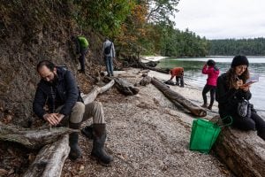
Naming leads to knowing, which leads to understanding. Residents of a small British Columbia island take to the forests and beaches to connect with their nonhuman neighbours
Wildlife
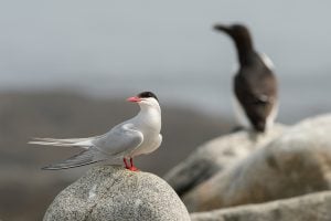
On New Brunswick’s Machias Seal Island, predatory gulls are pushing endangered Arctic tern colonies to the brink, creating a dilemma for wildlife managers