
Kids
Giant floor maps put students on the map
Canadian Geographic Education’s series of giant floor maps gives students a colossal dose of cartography and is a powerful teaching tool
- 1487 words
- 6 minutes
This article is over 5 years old and may contain outdated information.
Kids


It may have ended nearly 200 years ago, but this Canada Day, you can march up to Parliament Hill and experience the War of 1812, feet first.
The nation’s birthday will mark the debut of Canadian Geographic’s War of 1812 giant floor map, designed to commemorate the historic conflict’s bicentennial. The map, which is approximately 10.7 metres by 7.9 metres (about the size of a school gymnasium), is designed to be walked over and includes features such as the era’s forts, historic towns, battle sites and First Nations villages, as well as trails that British, American and aboriginal troops used.
A first for The Royal Canadian Geographical Society, the map was developed to create an interactive learning environment and further encourage students to explore Canada through geography.
Starting in the fall, five of the War of 1812 maps will travel the country and be available for Canadian educators to book for their schools for a two-week period, free of charge.
Kids
Canadian Geographic Education’s series of giant floor maps gives students a colossal dose of cartography and is a powerful teaching tool

Travel
How to make the most out of your visit to Disneyland, plus all the tips and tricks needed to ensure you and your family have a positive experience
Exploration
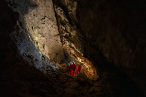
Offering a unique mix of discovery and challenge, these caving destinations make exploration beneath the surface both accessible and exhilarating
Travel
Tundra Buggy pioneer Frontiers North invites adventurous families to northern Manitoba for a bucket list summer vacation