Mapping
New mangrove forest mapping tool puts conservation in reach of coastal communities
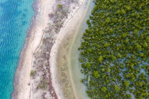
Mangroves provide a range of benefits, including protection from storms and the prevention of coastal erosion
- 1080 words
- 5 minutes
This article is over 5 years old and may contain outdated information.
Mapping

We know of Canada’s beauty from the ground; the open lakes, towering trees and jutting rocks that define the wild North.
What about from above?
We get glimpses from airplanes, of common air traffic routes over farms and cities. But since 2005, when Google Earth’s satellite technology went public, it is now possible to view this tremendous country in a new way and from a whole new scale. At times reminiscent of a Jackson Pollock painting, scanning through images of Canada from 10 kilometres above ground reveals a land that spans an intensely complex system of rock, soil, vegetation, lakes and human development.


Mapping
Mangroves provide a range of benefits, including protection from storms and the prevention of coastal erosion
Mapping
‘Maps aren't magic,’ says University of British Columbia prof — but during disease outbreaks, they can help us sort good information from bad
Science & Tech
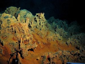
Researchers and industry leaders now have quicker access to data showing the complexity of the world’s seabed. Part five of Canada’s Ocean Supercluster: A six-part series.

Mapping
Indigenous rights activist and 60s Scoop survivor Colleen Cardinal discusses her project to map the Indigenous adoptee diaspora