History
Who won the war?
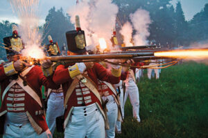
Soldiers, descendants of Loyalists and history buffs recreate a battle to demonstrate why the War of 1812 is still important today
- 3953 words
- 16 minutes
This article is over 5 years old and may contain outdated information.
History
The cannons that fired on September 11, 1814 set off the Battle of Plattsburgh, the last fight of the War of 1812. Two Canadians go south of the border to make things right.


On a sunny autumn morning — September 11, 1814, to be exact — four heavily armed British ships accompanied by a dozen gunboats sailed into a bay on Lake Champlain in upper New York State. They immediately opened a murderous fire with long-range guns on an American fleet lined up in defence of the village of Plattsburgh. One of the British cannonballs arced over the bay and flew through the door of a brick house that happened to be the headquarters of American General Alexander Macomb. It remains, to this day, lodged in the wall of that house and deep in the historical memory of every proud Plattsburgher.
That shot, which evokes an image nearly as terror-inducing as the attacks on the twin towers exactly 187 years later, set off the bloody and unevenly matched Battle of Plattsburgh, the last major engagement before the British and Americans struck a deal (the Treaty of Ghent) that ended the War of 1812. This summer marks the 200th anniversary of the conflict, and Plattsburgh, nestled in rolling, maple-forested hills on the western shore of Lake Champlain, is today a pleasant and picturesque little city of 2o,000 whose battle-scarred history is an enduring reminder of why it is never a good idea to get into a scrap with the neighbours.
That’s not the life lesson photographer Patrice Halley and I had in mind when we established our campaign headquarters just outside city limits in the handsome two-storey Point Au Roche Lodge owned by Creston and Karen Billings. Plattsburgh is little more than an hour’s drive south of Montréal and we thought a two-day excursion to the area might be an ideal way to separate the myths from the truths about a war that gave us the current Canada–U.S. border. While doing so, we aimed to sample the culinary pleasures of the region and do our bit to heal any hard feelings left by the war.
It was to be a charm offensive. So we began by advising the Billings, whose gourmet breakfasts are as splendid as the rooms they settled us into, that we held no hard feelings for the repeated invasions of Upper and Lower Canada by U.S. troops after the declaration of war in 1812. We blamed the truculence of the Brits for provoking the fight in the first place. After all, Upper and Lower Canada were mere colonies at the time, ruled by an empire at war in Europe with Napoleon. And at the outset of the war, French and English-speaking Canadians were, for the most part, bystanders or reluctant conscripts. That changed as U.S. troops and militia began razing villages, burning crops and imprisoning or killing farmers on the Canadian side of the loosely defined border. British troops, with their First Nations allies, did the same, and much worse, on the U.S. side.
On our first morning, we picked up touring bicycles at a local shop called Mountain Riders and were joined by local historian John Krueger, whose storytelling had us pedalling from landmark to museum to graveyard throughout the day. And what a tale he told.
Krueger began with a geography lesson. From the last ice age, the Champlain Valley has served as “an avenue of commerce and conflict” linking the St. Lawrence River to what became New York City. Lake Champlain is the central link in the artery. The lake drains north into Canada via the Richelieu River, which empties into the St. Lawrence. At its southern end, a short portage would take travellers to the upper reaches of the Hudson River, which empties into the Atlantic at New York. The Iroquois and other First Nations controlled the valley until the arrival of Europeans. Beginning in 1689, the French and British fought four savage wars along the valley. The lake became a battleground again during the American War of Independence and yet again in 1812. In each case, control of the waters allowed for the movement of troops, food and weaponry. Recent side-scan sonar surveys of the lake floor have pinpointed the locations of more than 300 sunken vessels, many of which were lost in various battles.
As we biked, the cool, blue waters of Champlain were always within sight. Krueger invited us to imagine the scene on that Sunday morning in September 1814. Four American ships with 820 sailors and gunners sat at anchor in a line, surrounded by 10 smaller gunboats. Facing them were 1,050 sailors, gunners and troops aboard the British ships and gunboats. We passed the brick house on Bridge Street with the cannonball still parked in its wall and biked on to the Battle of Plattsburgh Interpretive Center, where we viewed a clever diorama that showed the positions of the ships and the defensive batteries the American troops had built.
On land, the forces arrayed against each other were less closely matched. The Americans had 3,700 regular army troops and militia dug into defensive positions along the south bank of the shallow Saranac River, which bisects the community and empties into the bay. Facing them was a truly fearsome army.
The British had just defeated Napoleon in Europe and dispatched some 15,000 battle-hardened troops to Canada to bring an end to the war with the upstart Americans. Arriving in Québec, 4,500 of those soldiers were sent on to the Great Lakes in a feint that fooled the Americans into thinking that the Brits were planning an attack on American positions there. So the bulk of the American forces at Plattsburgh — 4,500 troops — were ordered on a fruitless march through the wilderness to join a campaign near the Niagara River. That left a much smaller force at Plattsburgh to face more than 10,000 welltrained British soldiers, the largest invasion force of the war.
From the Battle of Plattsburgh Center, we stopped for lunch at the Naked Turtle at Dock Street Landing. We sat on the patio overlooking a marina and boat launch, gazing out at the bay where the naval battle had raged, enjoying turkey burgers and beers in the peace and sunshine.
After leaving the naked Turtle, Krueger led us to a tidy colonial-era house surrounded by a white picket fence. This is the Kent-DeLord House Museum, which occupies one of the oldest residences in the Plattsburgh area. Built in 1797, it was seized by the British army and used as its headquarters during the battle. From its front windows, officers would have had a clear view of the ships squaring off against each other in the bay.
Beginning at 9:30 a.m., a total of 181 cannon aboard the opposing ships commenced firing. The opening shots also signalled British land forces to begin their assault. According to witnesses, some 300 residents gathered on a nearby headland to observe the two-hour spectacle of thunder and destruction on the bay that left the ship decks slippery with blood and strewn with mutilated bodies. More than 130 sailors perished and at least 160 were wounded in the engagement. When the smoke cleared, the Americans emerged as the victors. They had the advantage of the wind and an experienced commander, Lieutenant Thomas MacDonough, who knew the lake and had trained his sailors well. His heroism has been commemorated with a towering granite obelisk erected in his memory across from Plattsburgh City Hall.
Stepping into city hall, we viewed the massive main anchor from the Confiance, the flagship of the British fleet. Its officers surrendered to MacDonough. The anchor was lost during the battle and was only discovered by sport divers in 1996. It now occupies pride of place in the lobby.
When British commander Lieutenant General Sir George Prevost realized the naval battle had been lost, he concluded that without the fleet, “further Prosecution of the Service was become impracticable … and the possession of the Enemy’s Works offered no advantage to compensate for the loss we must have sustained in acquiring possession of them.” He ordered an immediate retreat to Canada, leaving “wounded on the field and a vast quantity of Bread, flour and Beef … besides a quantity of bomb shells, shot, flints and ammunition of all kinds.”
Prevost was widely criticized for his hasty withdrawal despite the numeric superiority of his forces. But he argued that taking and holding Plattsburgh would have been pointless without control of the lake. The American defenders could hardly believe their good fortune. They had been fed a steady diet of horror stories about the size and ruthlessness of the Brit veterans. When they realized their enemy had vacated the field, villagers danced with joy. Their victory has become legend and is recounted to every generation of local schoolchildren.
The following mor ning, we picked up kayaks from the shorefront Kayak Shack and met guide Jason Lowry for a day-long outing on the big lake. Our ultimate destination was Crab Island, a tiny, forested limestone outcrop roughly two kilometres offshore from Plattsburgh.
In bright sunshine, we paddled out to visit perhaps the most poignant memorial to the battle. The island is now a state park but in 1814 it was a military hospital. When the British navy surrendered, the Americans offered to have the enemy wounded treated alongside their own troops at the hospital and to bury the dead in a common grave. It was a gracious gesture made with the tang of gunpowder still on the morning breeze, and it helped initiate a healing process between the bitterest of enemies.
That graveyard, now overgrown and unmarked somewhere in the centre of the island, holds the bones of both the invaders and defenders from the one of the last foreign assaults on mainland U.S. territory until the terrorist attacks on September 11, 2001. Those soldiers and sailors may lack proper headstones but the peace made in that war has never been broken and remains the most compelling memorial to their sacrifice.
History
Soldiers, descendants of Loyalists and history buffs recreate a battle to demonstrate why the War of 1812 is still important today
History
In 2012, the Niagara region dusts off old battle sites to commemorate the war that defined our borders

Kids
Canadian Geographic Education’s series of giant floor maps gives students a colossal dose of cartography and is a powerful teaching tool
History
Sites across Canada honouring the war