This article is over 5 years old and may contain outdated information.

Places

Photos: Exploring the Torngat Mountains, a place of spirits

Canadian Geographic Photographer-in-Residence Michelle Valberg offers a glimpse at her journey to Torngat Mountains National Park in Labrador

  • Published Mar 03, 2017
  • Updated Dec 19, 2022
  • 356 words
  • 2 minutes
Torngat Mountains and Nachvak Fiord Expand Image
Advertisement

The ripples of the ship’s wake are the only sounds I hear as we creep toward the entrance of Nachvak Fiord on Labrador’s northern coast. As we round a point and enter the fiord, the clouds peel away and I see them — the Torngat Mountains, an ancient range of sharp and barren peaks that cover more than 30,000 square kilometres on Labrador’s northernmost tip.

I’m aboard the Ocean Endeavour, tour operator Adventure Canada’s 137-metre expedition cruise ship and my home for the next 10 days, as we journey up the Labrador coast through the 9,700-square-kilometre Torngat Mountains National Park, past waterfalls, Arctic wildlife, deceptively lush tundra, rugged coastlines and ancient burial grounds. From Nain, Labrador’s northernmost community, to Rigolet, near Goose Bay, we follow fiords and explore terrain so remote and wild it’s hard to believe that the Inuit, and the Dorset and Thule peoples before them, have survived, much less thrived, here for thousands of years.

Killiniq Island, at the northernmost tip of Labrador, is our first landfall. It’s uninhabited today but was once home to a Moravian mission, a Hudson’s Bay Company trading post and an Inuit community whose few members were relocated to settlements along Ungava Bay in 1978.

As the crew ready Zodiacs to take passengers ashore, our Inuit guides land first, scrambling up the rocky coastline, firearms on their shoulders, scanning the horizon for curious polar bears. As I step onto the island, the smell hits me first — that unmistakable, fragrant ether of bog-dwelling Labrador tea (called tilaaqiaq in Inupiaq, the local Inuit language), whose pungency is so enticing, it can make you dizzy. Used by the locals to treat everything from colds to lethargy and to even make an herbal beer called gruit, it’s now also being harvested as an anti-aging tonic.

As I scramble over frozen streams to an unnamed ridge at the back of an unnamed valley, I am reminded of what propelled me the region in the first place – few had stood where I stood. The knowledge thrilled me. 

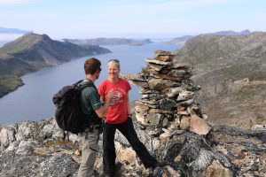
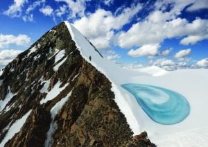
The following photos are some of my favourites from this wild, haunted land.

Aaju Peter looks out of the abandoned buildings in Hebron, an abandoned Moravian mission established in 1831. Once a thriving community, on Easter Sunday in April 1959, the missionaries suddenly left Labrador. They’d been sent to the region with the purpose of providing religious instruction to the local Inuit, but the rigours of northern life and the high cost of sending supplies to the remote settlement led to a mass relocation of the Inuit population to other communities further south and children being placed in residential schools.
Expand Image
Set against the strikingly beautiful landscape at Hebron, the skeletons of homes are being reabsorbed back into nature while carpenters are working to preserve the main building. As I walked through the old settlement, now thickly carpeted with blueberries, partridge berries and crow berries, I stumbled across an old graveyard. I wondered who these people were and how they lived. There’s a strangely comforting presence about Hebron, as if those people are still there, tied to the land.
Expand Image
The clouds lifted when we entered the Nachvak Fiord to reveal the Torngat Mountains. I can’t remember what I did first—gasp in astonishment or automatically pick up my camera. Either way, the effect of seeing the looming, ancient majesty of the Torngats took my breath away. And I never fully got it back for the ten days of the trip.
Expand Image
Caribou antlers were scattered all along the shores of the deep Nachvak Fiord. Many boreal and arctic animals call this area home, and for thousands of years the Inuit, and the peoples before them, have followed the migration patterns of certain species, such as caribou, throughout the region. Once ashore, we found bird blinds and meat caches left by Inuit hunters.
Expand Image
A morning reflection in the North Arm of the Nachvak Fiord. A thick crust of emerald lichen covers some of the slopes rising from the two-kilometre wide fiord.
Expand Image
Autumn foliage on the ground along the Labrador coast.
Expand Image
A panorama at the end of Nachvak Fiord. The vista is so huge—so much wider than the human eye can process.
Expand Image
Advertisement

Are you passionate about Canadian geography?

You can support Canadian Geographic in 3 ways:

Related Content

A crowd of tourist swarm on a lakeside beach in Banff National Park

Places

Smother Nature: The struggle to protect Banff National Park

In Banff National Park, Alberta, as in protected areas across the country, managers find it difficult to balance the desire of people to experience wilderness with an imperative to conserve it

  • 3507 words
  • 15 minutes
A mountain half covered in snow

Environment

Why mountains matter in Canada

They sustain us, enrich our lives and inspire us

  • 1287 words
  • 6 minutes

Places

National parks beginning to reopen across the country

Not all, but many of Canada's national parks will reopen to some extent on June 1

  • 438 words
  • 2 minutes
Parks Canada red Muskoka chairs on a snowy slope overlooking the Banff townsite

Places

Parks Canada to take ‘nature first’ approach to managing national parks

Responding to feedback from Canadians, environment minister Catherine McKenna promised a renewed focus on science and conservation for Canada's protected places

  • 754 words
  • 4 minutes