
Environment
Magical ‘light pillars’ photographed in wintry Northern Ontario sky
They may look like a science-fiction special effect, but the reality of this phenomenon is even more fascinating
- 261 words
- 2 minutes
This article is over 5 years old and may contain outdated information.
Mapping

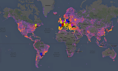
Is your city crawling with camera-toting tourists? Compare it with other photogenic cities using Sightmap, a sightseeing popularity heatmap that uses crowdsourced data to determine the most photographed place in the world.
The data comes exclusively from Panoramio, a photo-sharing site that regularly supplies photos to Google Earth. So, take the results with a grain of salt. It doesn’t account for photos shared to other corners of the internet, or – *gasp* – photos that not shared online at all.
As you may have deduced, the brighter areas indicate more photos being submitted in that place. Zoom in to explore somewhere you’ve never been, through the lens of others. Popular places also include links to Wikipedia and Foursquare among other sources.
Environment
They may look like a science-fiction special effect, but the reality of this phenomenon is even more fascinating

Travel
Here’s where to go to get the ultimate shot

Mapping
Mangroves provide a range of benefits, including protection from storms and the prevention of coastal erosion
Mapping
‘Maps aren't magic,’ says University of British Columbia prof — but during disease outbreaks, they can help us sort good information from bad