
People & Culture
For Acadians in southwest Nova Scotia, the mysterious Belliveau apple is a tangible link to the past
Untangling the roots of a hardy heirloom apple with ties to the Acadian deportations
- 3062 words
- 13 minutes
This article is over 5 years old and may contain outdated information.
History
In 1755 all Acadians who wouldn't declare allegiance to Britain were ordered to leave Nova Scotia. Here's where they went.

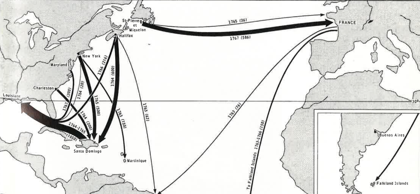
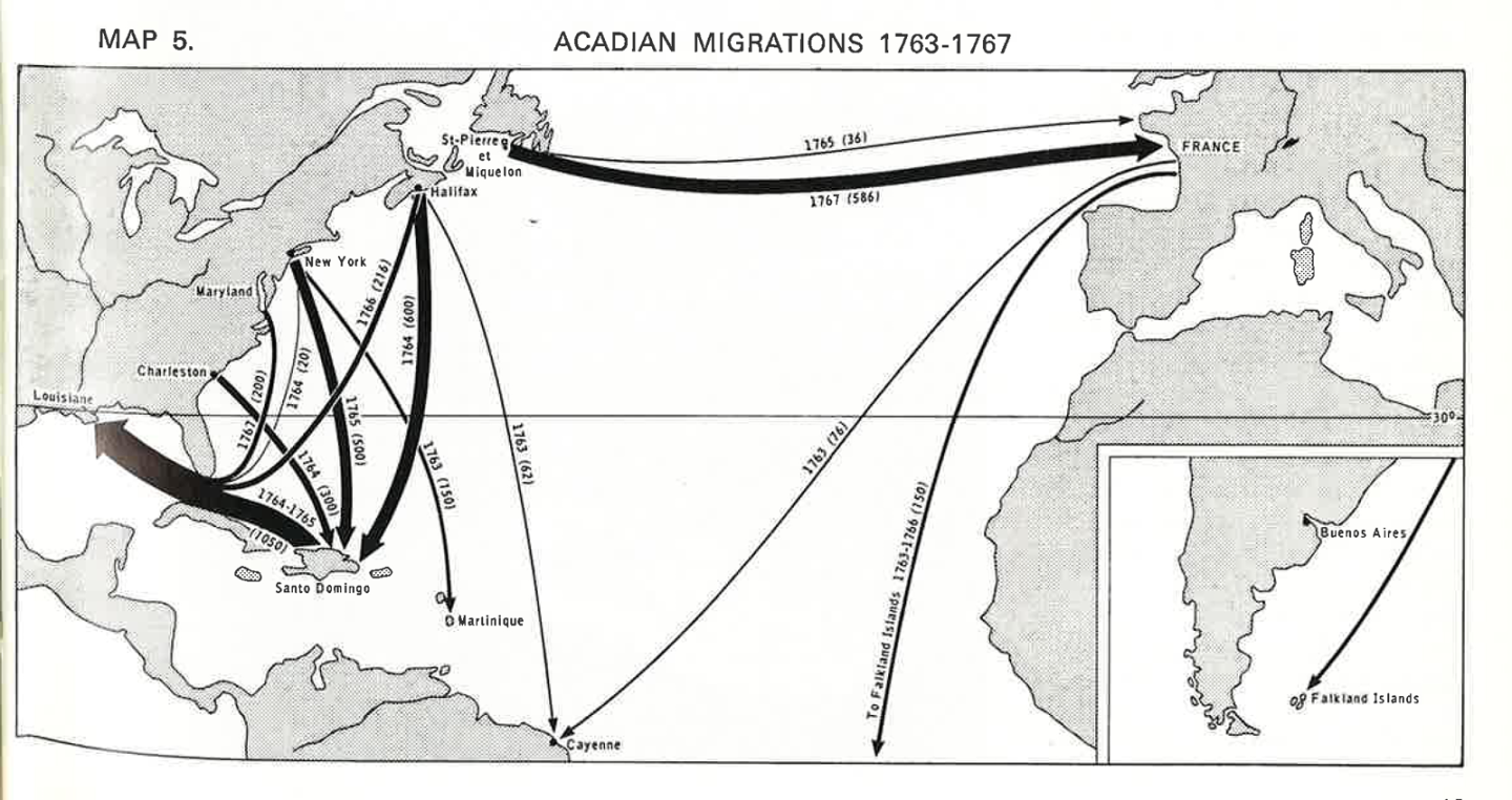
On July 28, 1755, British Governor Charles Lawrence ordered the deportation of all Acadians from Nova Scotia who refused to take an oath of allegiance to Britain. Over the following 13 years, approximately 7,000 Acadians were sent to numerous points along the Atlantic coast of North America, some to France and others to the Caribbean. Thousands died in transit, succumbing to illness in the filthy conditions of the ships. Those that did make it to their destinations were refugees, and often unwelcome, forced to wander in search of a home (some settled in Louisiana, helping to form the Cajun culture).
Acadia, referring to the region surrounding the Bay of Fundy (or Baie Francaise, as it was known at the time) in Nova Scotia, was settled by French colonists in the 17th century. It was isolated from the larger French settlement in the St. Lawrence Valley and as such, operated mostly autonomously, receiving few immigrants from France after 1671 and forming close ties with the Mi’kmaq. As tensions mounted between the French and British for control of what is now Canada, Acadia was plundered numerous times by the British, whose New England colony was situated just on the other side of the Gulf of Maine.
In 1713, with the Treaty of Utrecht, Acadia was ceded to the British. As the Acadians’ population grew, the British became increasingly nervous of their French loyalties and in 1755, Governor Charles Lawrence ordered his men to start arresting, with the goal of deporting, all Acadians in Nova Scotia who refused to declare British allegiance.
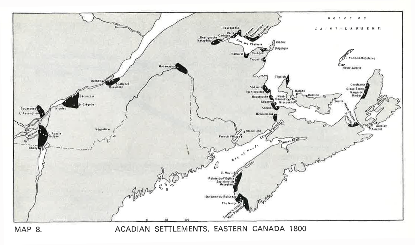
The Acadians’ subsequent migration, which lasted until the end of the 18th century, is mapped in detail in the “The Acadian Migrations” published in the July 1970 issue of the Canadian Geographical Journal. The article by Robert G. Leblanc first appeared in a science journal in 1962 and later in Cahiers de Géographie de Québec, a geographical magazine out of the Université Laval, which also created the maps. Here are a few of the detailed maps below, which, according to the article’s preface, “offer the best definitive account of the Acadian migrations we have ever seen.”

People & Culture
Untangling the roots of a hardy heirloom apple with ties to the Acadian deportations

People & Culture
The tintamarre showcases the vitality of the Acadian culture — and some supersized papier-mâché heads

People & Culture
Descendants of French-speaking Acadians in Louisiana saw their culture and language slip away in the 20th century. Now, a new generation of proud Francophones is leading a resurgence.

People & Culture
National Acadian Day is celebrated in Canada each year on August 15