Environment
Inside the fight to protect the Arctic’s “Water Heart”
How the Sahtuto’ine Dene of Délı̨nę created the Tsá Tué Biosphere Reserve, the world’s first such UNESCO site managed by an Indigenous community
- 1663 words
- 7 minutes
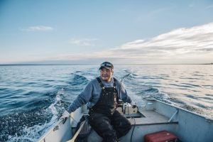
You can’t blame Sam Hunter for not being in the mood for a boat ride.
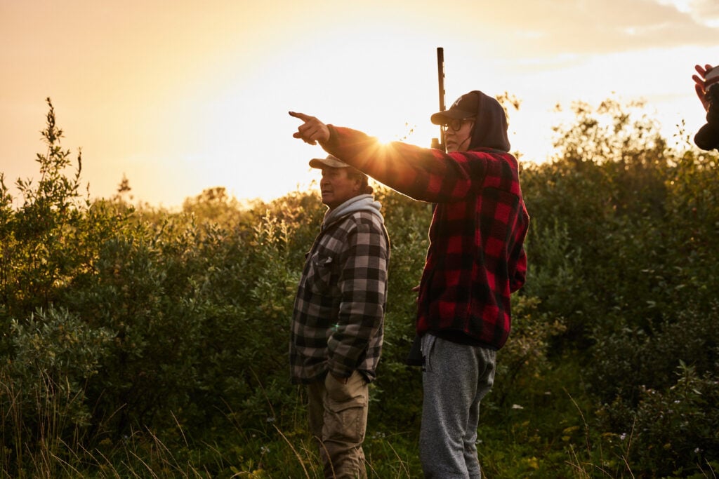
Rain is pelting the hamlet of Peawanuck, and the northeasterly wind coming in from Hudson Bay sweeps the coastal lowlands of northern Ontario. “I don’t like this weather,” Hunter says from underneath a furrowed brow, even as he and his German shepherd puppy, Niska, make their way by ATV from his house to the boat launch on the Winisk River. There’s no one there to brag about how good the fishing had been upstream, no one to lament how the thawing permafrost downstream is tearing apart the riverbank, leaving the bank swallows to search for new homes. And there is no one around to debate the merits of a proposal to formally protect the tawich, the coastal area with its tidal marshes, mudflats and rivers, and the sea beyond, to which Hunter and others from Weenusk First Nation are inextricably linked. There is only the voice of the river.
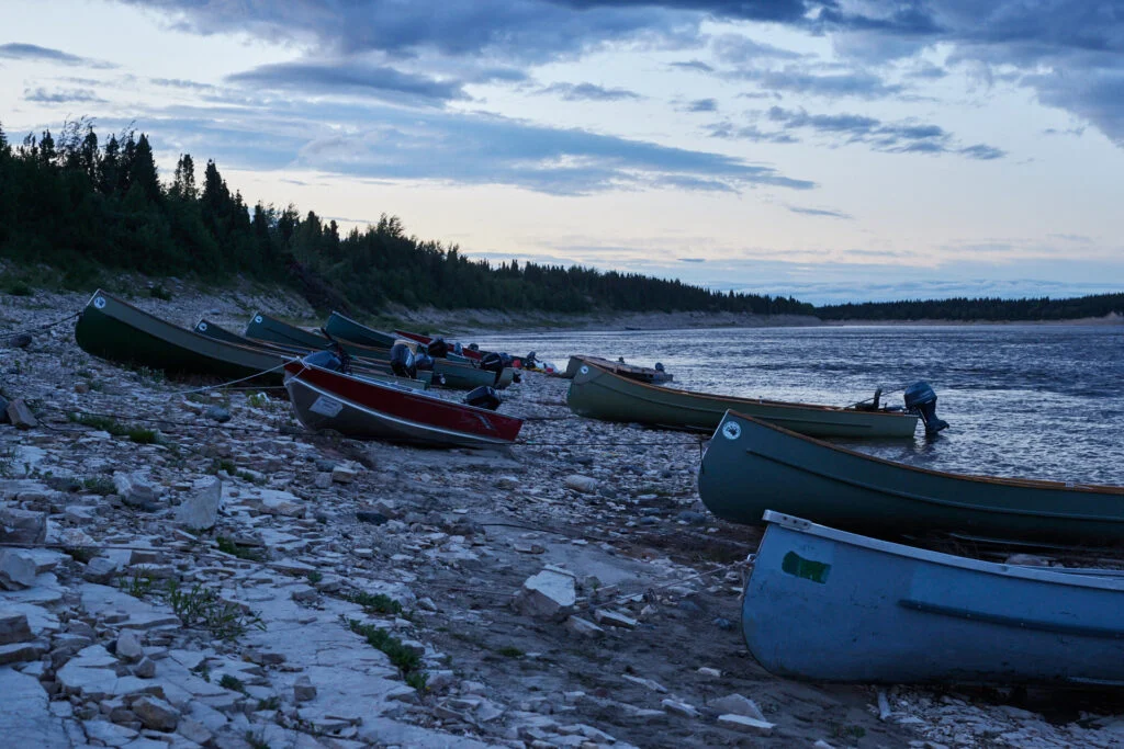
A dozen freighter canoes lie idle on the rocky bank, their owners no doubt thinking the same as Hunter. “I don’t like this weather,” he repeats, “but maybe it’ll get better by the time we reach the coast.”
Hunter is Omushkego Cree. He was born on the tawich and still lives off and for it. It’s his ancestors’ land as much as it belongs to his grandchildren, and it’s always been like that. But Hunter, Weenusk First Nation’s natural resources monitor, worries about the future. He’s seen first-hand the changes wrought by permafrost thaw, forest fires and a stunted sea ice season, driven by climate warming and endangering the animals and plants that underpin Omushkego culture.
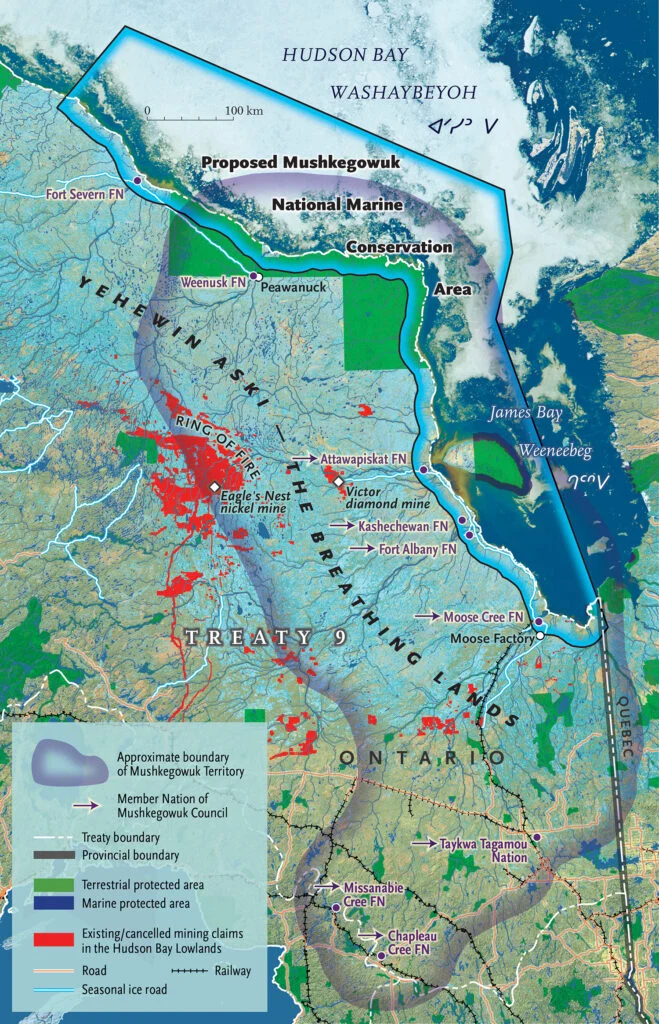
So, when the Mushkegowuk Council — the organization that represents seven Omushkego nations — and the federal government rolled out a plan to create a Cree-led marine preserved area along western Weeneebeg, or James Bay, and southwestern Washaybeyoh, or Hudson Bay, Hunter saw it as a step toward safeguarding the land for his grandchildren. While his community and Fort Severn First Nation to the northwest aren’t members of the Mushkegowuk Council, they’ve signed on to become part of the proposed Mushkegowuk national marine conservation area.
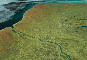
Stretching nearly 1,300 kilometres along Ontario’s northern coast — from the Manitoba border to Quebec — the offshore area and shoreline holds one of the most biodiverse and pristine ecosystems on the planet, supporting beluga whales, polar bears, walruses, caribou and millions of shorebirds, ducks and geese that nest or stop over during their migration.
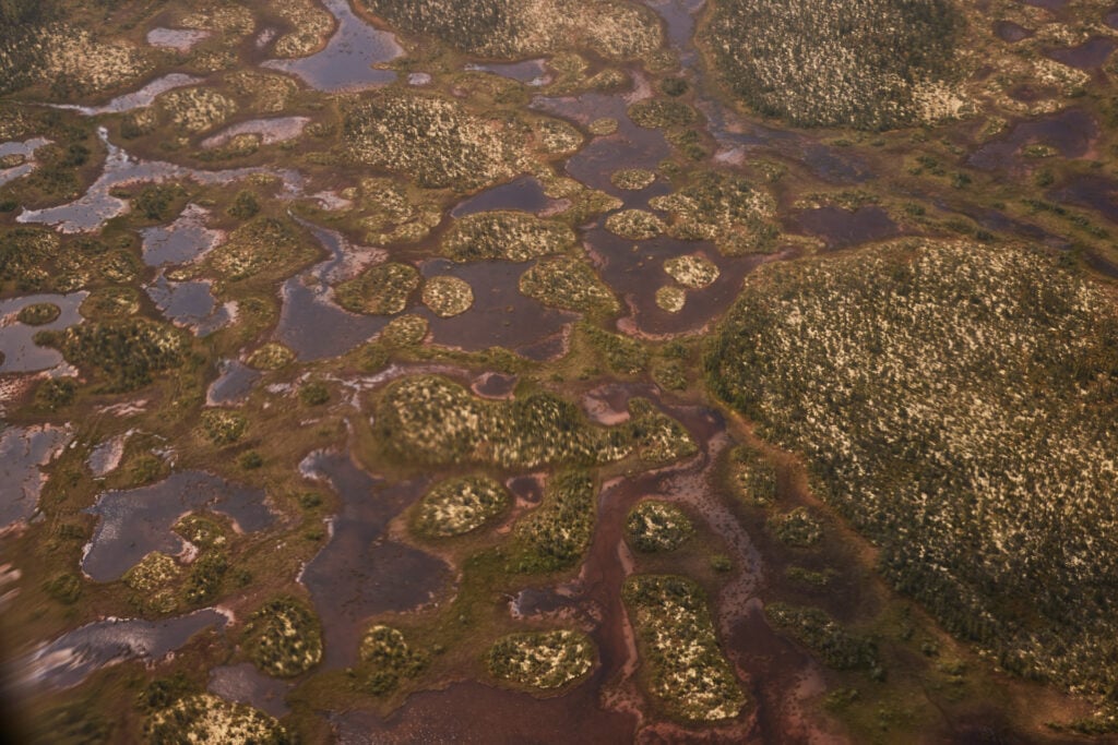
While the conservation area aims, at least in its first phase, to protect the offshore marine area, the tawich is both water and land. Omushkego don’t compartmentalize geography the way western society tends to do, seeing the land — the terrestrial and the aquatic — in a holistic way. For Hunter and other community members in the region, going out on the tawich can mean net fishing on the mudflats, berry picking on a bog, goose hunting on an island, trout fishing on a river or travelling on the bay. The land here is a patchwork of bogs, fens and wetlands, stitched together by peat and animal paths: moose and caribou on firmer ground, birds on the fluid border between land and sea. Above it all hangs a web of flyways, a loose gauze carrying winged migrations.
The Omushkego refer to this vast wetland area as Yehewin Aski — the Breathing Lands. They’ve understood its significance since time immemorial. That’s why an Omushkego-led national marine conservation area is so vital — and not only for the land-based culture; the formalization of Cree stewardship would also mean a greater chance for Canada and the world to reach biodiversity goals as set out in the United Nations-led Kunming-Montreal Global Biodiversity Framework.
Hunter has already been engaged for years in the preservation of the tawich, working both for his First Nation and with research scientists to monitor and record biodiversity, water quality, weather and landscape changes. But the official approvals process for the Mushkegowuk national marine conservation area got underway in 2024 — all communities in the area must vote in favour of implementing the marine conservation area for it to become reality. One of the reasons Hunter needs to go to his coastal cabin on such a dreary day is to get ready to host a team from the National Audubon Society and the Toronto-based conservation group Wildlands League; there’s some tidying up to do after a black bear rummaged through it for food the previous week.
So, despite the weather, Hunter pushes his boat into the current. Zigzagging downriver to avoid propeller-shattering shallows, he looks stressed as he glances up at slate clouds colliding with black spruce. But the closer he gets to the sea, the smoother his facial expression becomes; by the end of the two-hour boat ride, he almost looks content. “I still don’t like this wind,” he says as he ties the boat to driftwood. “But I think we’re in for a couple of nice days.”
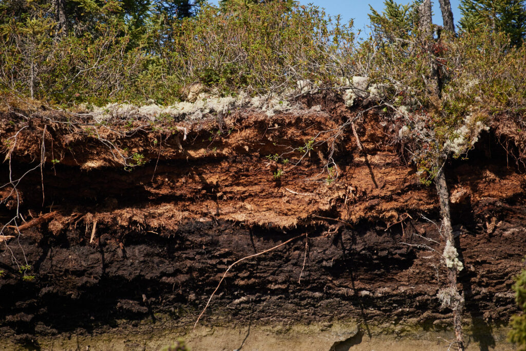
The wind foils Hunter’s plan to fish. (The traditional Omushkego way is to drive stakes with a net into the mudflat at low tide and pluck fish from it at the next low tide.) While cooking caribou and mashed potatoes on the woodstove, he says willows have crept closer to the coast over the past 40 years. The land here used to be tundra-like, save for a few knee-high shrubs. Those shrubs have grown to become trees. “The Elders say this kind of growth has not been seen in over a thousand years,” Hunter says. The permafrost is thawing, and the ground, once frozen firm, is now soft or even swampy, allowing plants to move in and take root and willows to shoot skyward. “It’s less safe now because bears come right up to the cabin before you know it.”
The following morning, Niska starts barking at 7:30. The sun is up, but Hunter is not. He stayed up late stoking the fire, trying to stave off the chill from the north wind, which makes early August feel like late October. It roars as it rounds the cabin, but the dog is louder. “Shit!” groans Hunter and catapults out of bed. After a scramble to find his glasses, he reaches for his shotgun and opens the door.
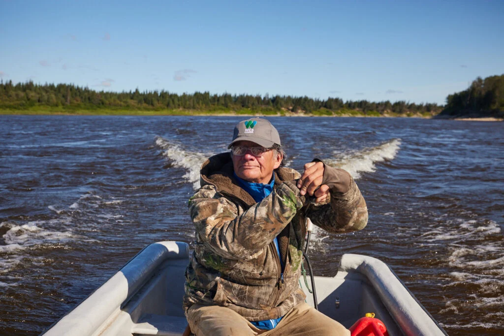
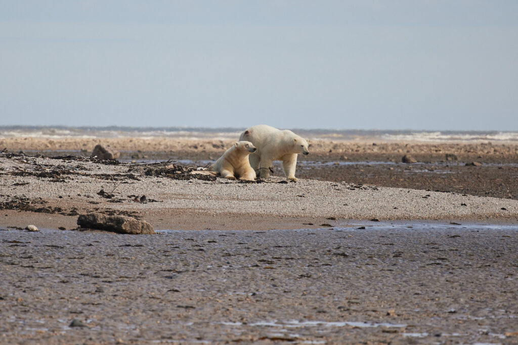
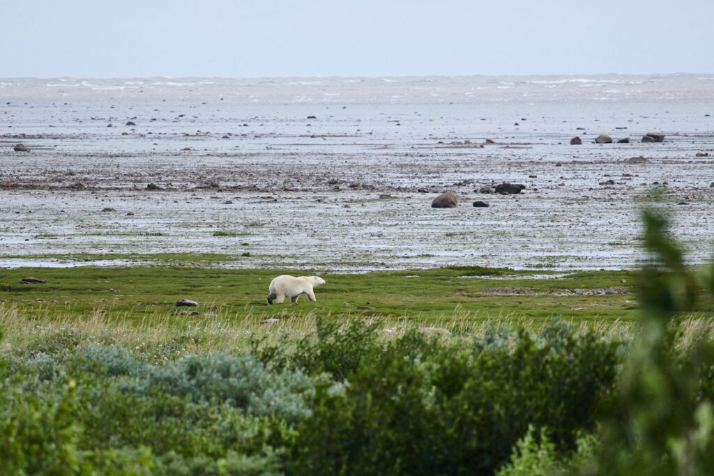
“Stay inside! And if I say so, get up on the roof,” he orders, pointing to a hatch in the ceiling. He closes the door behind him. A shot rings out. Terrified, Niska keeps barking. Another shot. A mere 30 metres from the cabin, wapusk, the white bear, turns around toward the sea. Nerves calmed, breakfast out of the way, Hunter goes for a ride on his eight-wheel Argo, an ATV that can caterpillar its way over rocks and through mud holes and rivers.
The morning visitor is nowhere in sight. Still, Hunter stops frequently to scan the horizon. An estimated 900 to 1,000 polar bears roam southern Hudson Bay while they’re waiting for the sea ice to form so they can hunt seals again. It’s a wait that’s getting longer each year. So in the ice-free summer, polar bears sniff out mussels on the mudflats. “And over the past 20 years, I’ve seen them adapt to eating moulting geese and ducks,” Hunter says, adding that without their flight feathers, fowl are easy prey. But most often, wapusk prefers to lay low to conserve energy.
Hunter stops the Argo; he’s spotted something in the distance. Boulders? He aims his binoculars: two massive bears slumbering on a bed of seaweed. “When I’m gone,” he says, “I want people still to be able to see polar bears, and belugas and birds.” The marine conservation area would let sleeping bears sleep, safe from industry. It could also help the Breathing Lands breathe free.
“If you don’t protect the watershed, if you don’t protect the peatlands, you aren’t protecting the bay.”
YEHEWIN ASKI — or the Hudson Bay Lowland, as scientists call it — is the second-largest carbon store on the planet, even larger than the Amazon rainforest. Holding between 30 billion and 40 billion tonnes of carbon in the peat and permafrost, the lowland plays an enormous role globally in mitigating climate change — as long as it’s kept intact.
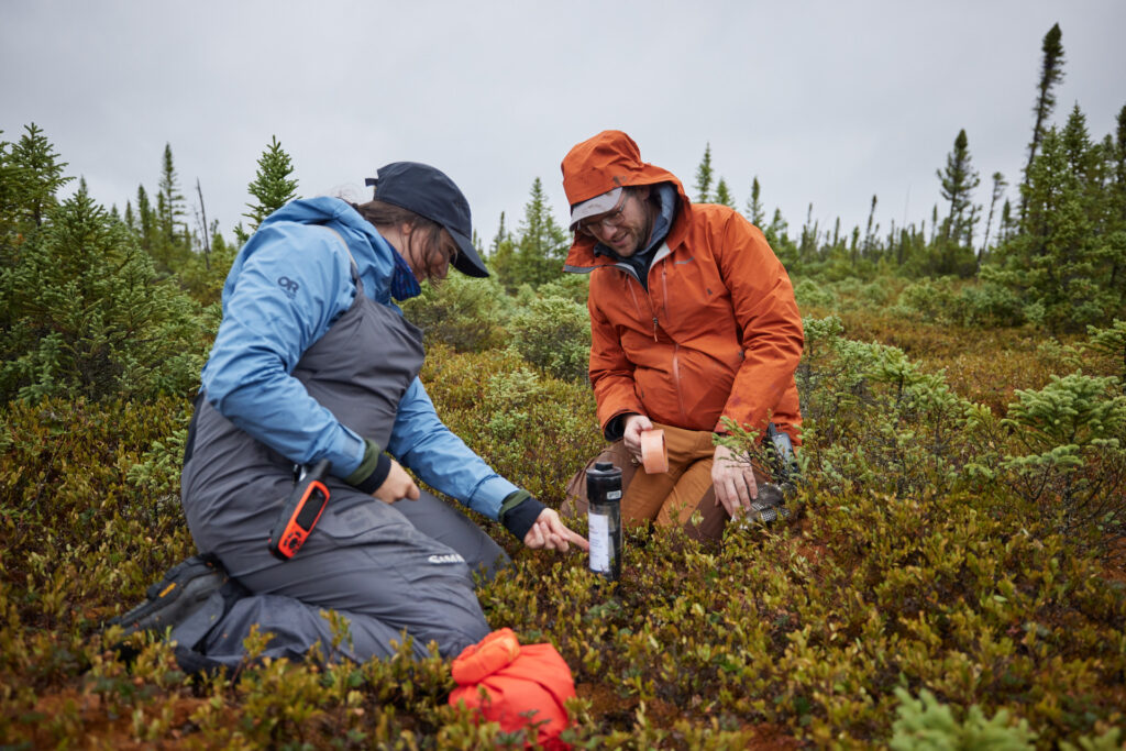
Around the time Hunter is scaring off polar bears, Lorna Harris, Adam Kirkwood and Haley MacLeod of Wildlife Conservation Society Canada are busy installing permafrost monitoring equipment to track ground temperatures around Peawanuck at sites chosen with input from Hunter. As the team heads out on one of the bogs, they can barely walk straight across the quaking carpet underfoot.
Harris and Kirkwood have been tracking peatland dynamics in the region for years, while MacLeod, an aquatic ecologist and toxicologist, is here for the first time, interested in monitoring whether thawing permafrost leaches methyl mercury into rivers. While the three support the creation of a national marine conservation area, they stress that to do so properly, it’s also necessary to protect the watersheds that flow into the Hudson and James bays. “Bogs hold rainwater. Any excess can drain into fens, which in turn can release water into rivers,” explains Kirkwood as he pulls a chunk of frozen peat from an auger. Harris puts it more bluntly. “If you don’t protect the watershed, if you don’t protect the peatlands, you are not protecting the bay.”
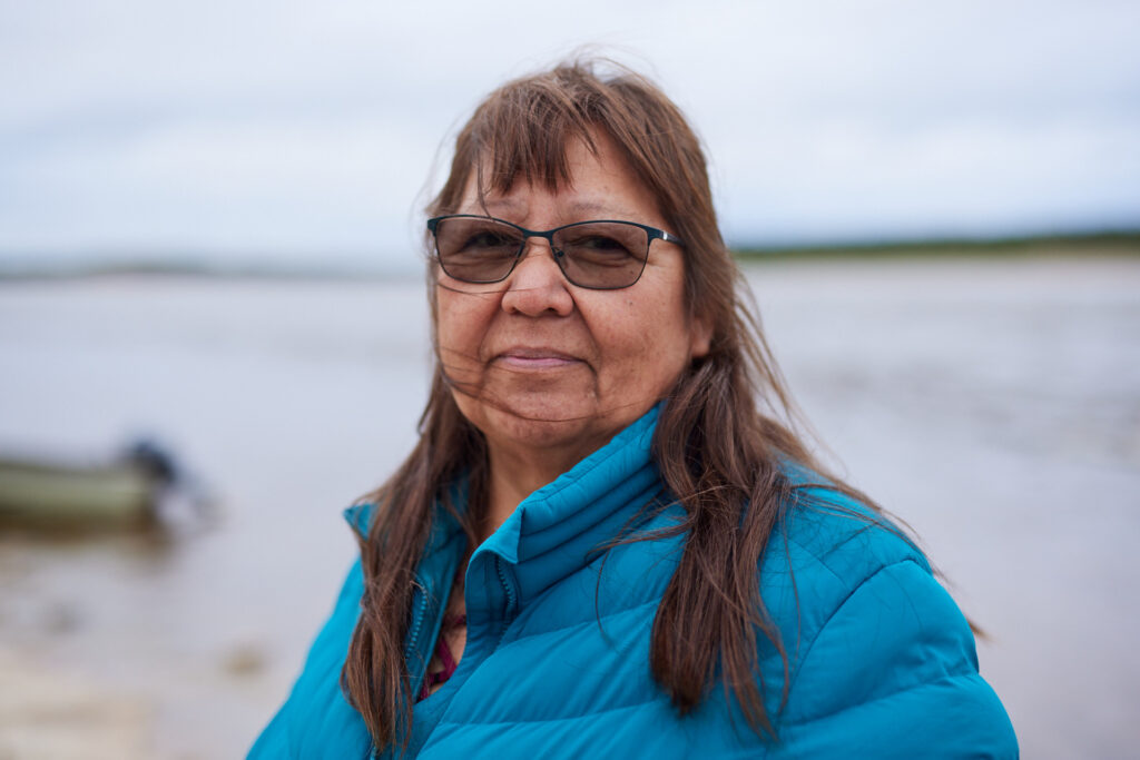
The land here is at once terrestrial and aquatic. For the animals to thrive, “keep the land the way it is,” says Margaret Mack as she stops by Peawanuck’s boat launch on the Winisk River. The community’s nurse, Mack grew up on the tawich and has a camp not far from Hunter’s on Washaybeyoh. She’s eager to retire so she can spend more time on the land, teaching youth how to pluck geese, gut fish and snare hares. For Mack, long-term wealth means keeping the tawich natural. She points to promises of jobs made by the Victor diamond mine south of here, which she says ended up being short term before the mine closed completely in 2019. “I worry about what’s going to come floating down the rivers if mining starts in the Ring of Fire,” she says, turning her eyes onto the Winisk, into the wind, which keeps pushing her long hair across her face.
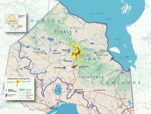
Mack’s worry is shared by Lawrence Martin and Ernest Beck. Nearly 800 kilometres south of Peawanuck, in one of the Mushkegowuk Council’s offices in Timmins, the two have just wrapped a staff meeting. Off to one side, a map outlining Treaty 9 codifies the dream of a Mushkegowuk national marine conservation area.
Martin, the director of the council’s lands and resources department, traces a finger inland from James Bay to a roughly 5,000-square-kilometre area known as the Ring of Fire. He then taps on a sheet showing more than 30,000 mining claims in the Ring of Fire alone. “This is what we’re up against,” he says, then pulls out a copy of the Omushkego Wahkohtowin conservation plan (wahkohtowin roughly translates to “kinship with the land”). “Our goal is to protect all of our treaty lands from forestry, mining and hydroelectric projects that may cause harm to Cree culture,” he says. “Protecting the marine area through an NMCA is the first step — the tool that’ll allow us to bring land protection to the table.”
The Mushkegowuk Council has sought funding and support to protect their land since the ’80s. But it wasn’t until the federal government’s 2019 announcement that it would work to protect 25 per cent of Canada’s land and oceans by 2025, and 30 per cent by 2030, that they saw action. Beck and a group of council members got busy writing letters to drum up political and financial support for a marine protected area.
In 2020, they approached Parks Canada, whose objective is to create at least one national marine conservation area in each of Canada’s 29 distinct marine regions, including James Bay and Hudson Bay. And in 2021, the council signed a memorandum of understanding with Parks to carry out a three-year feasibility study to gather the evidence to recommend Weeneebeg and Washaybeyoh for a designation — an inventory of what makes the tawich special, explains Martin.
Together with Parks Canada, the council recorded the biomes, species and habitats along the coast and offshore and collected knowledge from Elders and land users to map the area’s inherent values. At a gathering in Kashechewan, near James Bay, in February 2024, they announced the results: the study area did indeed warrant protection, and the recommendation to create the Mushkegowuk national marine conservation area became official. While the proposal announced that day was for the offshore area (86,000 square kilometres up to the low-water mark, representing 1.5 per cent of Canada’s oceans), discussions have already begun around a possible phase 2: the expansion of protection up to 20 kilometres inland — should Ontario and Nunavut (which has jurisdiction over the bay’s islands) agree.
The national marine conservation area forms part of the larger Treaty 9 protection objective in the Wakohtowin conservation plan. As Beck puts it, “sea and land are connected; they’re one.” And if anyone needs proof of a tangible link between the terrestrial and the aquatic, consider the polar bear. Ontario is one of the only places in the world where female polar bears, after heading into the lowlands from the bay, dig a hole in the peat to give birth.
Sam Hunter, for one, has seen mother bears and cubs as far as 160 kilometres inland from his nearshore camp — emphasizing the need for Indigenous knowledge, participation and leadership in conservation.
It also underscores why the Omushkego Cree want the land protected from industrial development: if you disturb the peatlands, you undermine both the habitat of species important to Cree culture and the future of the Hudson Bay Lowland as a climate buffer for the entire planet.
Yet the national marine conservation area proposal is not without opposition. For starters, “Ontario wants mining, not conservation,” says Martin about the provincial government’s eagerness to open the Ring of Fire to critical-minerals extraction. It’s been challenging to get the province to hear the council’s arguments for expanding the marine protected area inland.
Locally, there’s mistrust of what is essentially a government scheme. (A national marine conservation area is initiated by the government, unlike an Indigenous protected and conserved area, which has weaker legal protections.) Initially, people worried their inherent, treaty and constitutionally protected rights to hunt, fish and trap on traditional territories might be diluted under a government project that endorses conservation. It’s a valid concern, considering Canada’s history of having excluded Indigenous Peoples from or limiting their access to traditional lands for the sake of creating parks. “But the whole idea with this NMCA is to strengthen Omushkego control of our lands and waters, and that includes upholding our inherent and treaty rights,” says Martin.
Beck adds that the national marine conservation area “will be Cree led, with Parks Canada in a supporting role.” Despite skepticism, there’s cautious optimism all nine communities will eventually vote in favour of the proposal. And if things turn out the way Martin and Beck hope, the conservation area should give the Omushkego Cree the sovereignty they need to shape their current and future kinship with the tawich.
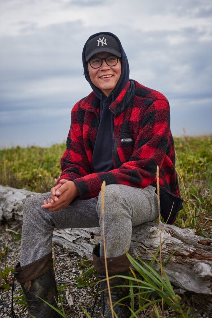
HUDSON BAY isn’t the only part of the tawich where polar bears roam. They’re also at home on James Bay, even if there aren’t as many as farther north. About 300 kilometres southeast of Hunter’s cabin, Jeronimo Kataquapit grabs his shotgun and starts walking along the shore from his family’s campsite on one of the Twin Islands. Waves, pushing up on the cobbles, make the Hudsonian godwits and lesser yellowlegs seem part of the surf, sprinting up and down the beach with each wave as if they were the tasselled edge of the sea.
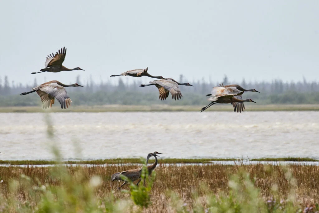
Crossing toward the opposite side of the small island, Kataquapit soon finds himself wading through a sea of his own, one in which the waves washing over his feet come in white, purple, yellow and pink. In the distance, the swaying flowers swaddle flocks of sandhill cranes doing their best to outperform the wind. Kataquapit seems at ease here — despite sussing out if a white spot in the distance might be a polar bear.
By the time Kataquapit strolls back into camp, his father, James Kataquapit, has finished making frybread, a killer version with raisins that no one — not even Jeronimo’s mother, Monique Edwards — has been able to replicate. James, his hair tied with an elastic beneath a camo ball cap, grabs a couple of frybreads and a thermo mug of tea, then sits down to stoke the fire he’s just lit. Jeronimo sits down beside him. They chat about not starting up the internet, because that would use up fuel needed for the boat ride back to Attawapiskat, and about Monique not coming out on this tawich getaway because she was busy doing the final planning for the opening of the community’s highly anticipated youth centre.
Father and son didn’t initially see the benefits of a marine conservation area when the idea first came to their community of 1,500 people. Misinformation had spread that it would erode Indigenous inherent and treaty rights, which James feels stemmed from insufficient communication. “Elders and bush people like me don’t use technology,” he says about the mostly online updates coming from the Mushkegowuk Council. But Jeronimo is plugged in. When he realized the potential for preserving Cree traditions — knowledge he is still learning by spending time on the tawich with his parents — he set out to convince his mom and dad.
As far back as he can remember, his parents have always been on the land, providing for their family and passing on knowledge they inherited from their parents and grandparents. With the recurring threats from outside to strangle rivers in hydro dams, clog the bay with wind turbines and desecrate the peatlands for minerals, Jeronimo feared for the future possibility to practise Cree culture. Those concerns helped him turn his parents into proponents of the marine conservation area.
“I worry about what’s going to come floating down the rivers if mining starts in the Ring of Fire.”
“The NMCA is important for protecting the sea, but it’s also a way to encourage protection of the land and the rivers,” James says, rubbing his hands in the fire’s heat. “We don’t see those areas as separate.”
While James adds wood to the fire, Jeronimo goes to fetch a piece of caribou from a cooler. He comes back empty-handed. “We forgot it at home,” he says, but it isn’t a big deal, because “food is all around you.” So, they go looking for geese. A gaggle is only a few hundred metres away, bathing in the sunshine but beaten by the wind.
Jeronimo waits. And waits. But the geese refuse to fly, the wind saving them this time. Over dinner of hot dogs and frybread, James says he hopes the marine conservation area will protect geese and other beings. “We have a responsibility to speak up for the animals. We have to be their voice,” James says.
But speaking up hasn’t always come easy. “I used to be shy,” he reveals, especially when the people around him spoke English, a language he didn’t learn until he started working as a “tire man” at the Victor diamond mine, 90 kilometres upstream from Attawapiskat, in 2006. “But I got to a point where I could no longer keep quiet.”
If actions speak louder than words, James and Monique have both made themselves clear by going upriver to the Ring of Fire to mark Cree sovereignty — being present on the land, observing and recording changes, mapping old burial sites and even planting the Attawapiskat First Nation’s flag there.
Jeronimo expresses his voice through the videos he’s producing to bring the tawich to those who can’t imagine what it’s like. “Most people think Ontario is all forest,” he says, “but Omushkego land is so much more. It’s my home, my history, my people.” His storytelling, which showcases the vastness of Omushkego land and its rich biodiversity, has earned him credits toward his undergrad studies in geography and environmental management at the University of Waterloo. The decision to study science came in his early teens when he started asking questions his parents didn’t have answers for: why the river’s water level is getting lower, why new species of birds, such as cormorants and pelicans, are expanding their range into the area.
By bridging two knowledge systems, Jeronimo hopes to create a clearer image of what’s happening to the land and animals — and in turn, his people — so he can help guide positive change, perhaps as a GIS specialist and land guardian. (The national marine conservation area, if approved, comes with funding for guardian programs and other job opportunities in the communities.) “It’s hard for people to grasp the love we have for this land,” Jeronimo says.
Southerners tend to see the tawich as wilderness or as a park, even though it has always been animated by people. “For us, it’s our life, and we have a duty to defend it,” he says. He believes the marine conservation area can become reality if the Mushkegowuk Council can better communicate why it matters to Cree ways of being. “It has to go through,” Jeronimo emphasizes. “The land has always looked after us. Now it’s time that we give back to the land by protecting it.”
This story was funded by a grant from the Institute for Journalism and Natural Resources.
Environment
How the Sahtuto’ine Dene of Délı̨nę created the Tsá Tué Biosphere Reserve, the world’s first such UNESCO site managed by an Indigenous community
Mapping
Canadian Geographic’s cartographer explores the many facets of the Hudson Bay Lowlands, one of the world’s most significant wetlands
People & Culture
For community members in Waskaganish, Que., the place where Cree traders established first contact with company employees, it’s just a chapter in a longer history
Environment
The James Bay Lowlands in northern Ontario contain one of the largest potential mineral reserves in Canada. Now, the region’s economy and environment stand on the brink of massive transformation.