
Exploration
Last icy stand: Scaling Mount Logan
Four researchers team up to ascend Mount Logan, measuring change and resilience on Canada’s highest peak
- 3316 words
- 14 minutes
This article is over 5 years old and may contain outdated information.
Exploration
In 1992, a team backed by The Royal Canadian Geographical Society became the first to accurately measure the height of Mount Logan, Canada’s highest peak

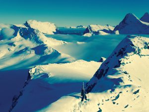
We crawled out of our tents on the morning of June 6, 1992, to behold a beautiful day on the roof of Canada. Five of us were at Camp 6, 5,640 metres above sea level, poised to make the final push to the white summit two kilometres distant and some 300 metres higher. While the rest of Canada may have been basking in warm spring weather, we gazed out on a sun-dazzled mountainscape of ice, snow and the characteristic deep blue sky of the thin atmosphere at high altitudes. Barring any change to these ideal climbing conditions we would arrive at the summit of Mount Logan, Canada’s highest point, by mid-afternoon. On any other climb, we would have arisen early and pressed our bid for the summit while the good weather held. This, however, was no ordinary ascent: we were combining science with climbing and our summit bid had to be timed carefully to coincide with the position of satellites that orbited far over our heads.
Charlie Roots, always optimistic and raring to go, was loaded down with 20 kilograms of satellite receiver, antenna and battery. “Let’s see how high this thing is!” he exclaimed as he, Patrick Morrow and I set off on our telemark skis burdened by this array of high-tech survey gear. I reflected on Charlie’s remark and on the many months of planning and preparation that had brought us here. Strange as it may seem, we didn’t know for certain the height of the mountain we were climbing. ln fact, nobody was certain of the height of Canada’s tallest peak, in the St. Elias Mountains in the southwestern corner of the Yukon. Traditional measuring techniques had narrowed the gap to between 5,951 and 6,050 metres, but the prevailing harsh weather, remoteness and immense size of the mountain massif made it very difficult to obtain reliable and accurate measurements from the ground. We would try to avoid some of those problems by measuring from the sky instead, using the relatively new satellite-based technology called the Global Positioning System (GPS) – determining the altitude and location by simultaneously measuring distances from several satellites in a known orbit around the earth. The exact height of the tallest mountain was something Canadians really should know about their country. Obtaining the measurements to determine the elevation had turned into a very exciting project, much more so than I had imagined many months earlier.
The seed for the idea to measure Mount Logan’s height was planted by an article I read in Canadian Geographic magazine in 1990, which said that the precise height of the peak was not known. Due to my long interest in Mount Logan as well as my surveying background, I became interested in resolving the debate using GPS technology. In the late winter of 1990-1991, my employer, the Geological Survey of Canada, canvassed its staff for ideas for unique projects to celebrate the 150th anniversary of the Survey in 1992. With the idea still fresh in my mind and with the enthusiastic encouragement of Charlie Roots, I proposed a project to measure the height of Mount Logan, named after Sir William E. Logan, the Survey’s distinguished first director. A team of climbers and scientists could measure the height using the lightweight GPS instruments currently available. Furthermore, the team could gather rock samples and undertake other geological studies. This seemed an ideal way to celebrate not only the GSC’s 150th anniversary, but also Canada’s 125th birthday and the 50th anniversary of the Alaska Highway, which runs along the border of Kluane National Park where Mount Logan is located.
While the proposed project was enthusiastically endorsed at the GSC, the Survey felt it would be too large an expedition to mount on its own. As a result we approached The Royal Canadian Geographical Society and asked it to consider becoming our principal sponsoring agency.
To our immense relief and delight, the Society’s board of directors gave the project the green light on December 12, 1991. But there was precious little time left to acquire food, tents, sleeping bags, clothing and climbing gear: our date with Mount Logan was May 1992, a mere six months away. I placed the first of many equipment orders the very next day. Ultimately, we received support from several project partners, support which allowed us to obtain the high-quality, reliable gear so vital on expeditions to mountains such as Logan.
While there are many mountains around the world taller and perhaps more daunting than Mount Logan, it is often underestimated by climbers. Lloyd Freese, who has been involved in numerous rescues on the mountain, has experienced the vagaries of the unpredictable and severe storms that can plunge temperatures into the -40°C range in midsummer. With little or no warning: “We’ve had bad weather move in in minutes, virtually. You could be traveling along in nice weather and sunshine, and all of a sudden you’ll get fog, high winds or a storm coming off the ocean.” The Gulf of Alaska, visible from the summit, is a mere 80 kilometres away and affects the weather profoundly. The nearest road and airstrip is 160 kilometres distant, and help is at least a one-hour flight away. As Lloyd so often points out to climbers coming to the park, rescue flights may be impossible because of the danger to rescuers due to bad weather and altitude: “We say that we simply don’t have a rescue capability at high altitudes, for the big mountains of the St. Elias.”
To carry out the expedition’s objectives under such conditions, we selected a team that would balance science with mountaineering experience; a group that would be able to get along well and help each other whenever necessary. In the last week of April the team assembled at the Arctic Institute of North America’s Kluane Lake Research Station on the Alaska Highway. The ensuing week was frantic with packing, GPS refresher training and other preparations. The excitement increased as the time for our 160-kilometre airlift to Logan Base Camp approached. Charlie, who had been instrumental in helping to get this project started was, as usual, overflowing with enthusiasm: “It will be really fun to be able to say, ‘Hey, look, we went into this wild, inhospitable place and we did good science.’”
By doing “good science,” we all hoped that we might spark interest in the St. Elias Mountains, their origin and their rate of growth, among Canadians from coast to coast.

On the evening of May 10, the expedition was finally ready to start flying climbers and equipment to the mountain. The airplane shuttled us over an awe-inspiring expanse of glaciers, mountain ridges and massive peaks. In nine trips over three days, pilot Andy Williams transferred us to our Logan Base Camp at an altitude of 2,760 metres on the Quintino Sella Glacier at the base of Mount Logan’s King Trench. As Andy’s single-engine Helio Courier ski-plane set down load after load on the rolling glacier, our 1,300 kilograms of equipment grew to an impressive pile anxiously eyed by all of us. This seemingly unmovable mound of gear included food and fuel for 40 days, climbing equipment, packs, sleds, skis, GPS receivers, a notebook computer, batteries and solar panels — all of which we would have to ferry up the mountain in sleds and on our backs. A regular climbing party on the King Trench route, not encumbered by scientific equipment, might consider 21 days of food adequate.
Sue Gould, who had spent every spare moment of the preceding six months designing, testing and packaging our meals, was particularly relieved to see the climb finally under way. Her chilies, sweet and sour dishes and other delicious foods provided each one of us with 5,500 calories daily, and remained popular throughout the expedition.
For logistical and safety reasons, the expedition set up its own radio base at the Kluane Lake Research Station. Every morning and evening we established radio contact with base managers Ulrike Schmidt and Helen Butler at Kluane Lake. Through them we were able to receive regular weather forecasts as well as updates on the status of the GPS satellites.

Between Logan Base Camp and the summit, which rose some 3,200 metres above us, there stretched close to 30 kilometres of ice and snow along the King Trench route. This route, the most popular on the mountain, provided the key to Mount Logan during the first successful ascent in 1925. We awoke on the morning of May 16 to a sunny and surprisingly warm day, ready to break trail and to move to Camp 1 at 3,330 metres, halfway up King Trench. We traveled slowly as our bodies were still not accustomed to carrying packs and hauling sleds in the thin air. Despite the slow pace our spirits soared as we marveled at the magnificent scenery, especially King Peak looming high above the trench with its huge blocks of ice and snow precariously attached to the mountain’s magnificent flanks, as if poised to sweep across our path at any moment. Fortunately, they never did. We had tried to time the trip to occur after the winter’s worst cold, but before the warm temperatures of late spring could loosen the snow and ice, increasing the risk of avalanches.
As we lost sight of Base Camp, we found comfort in the knowledge that it was indeed possible to move our equipment and food up the mountain even if it did take three-daylong carries by each climber to move a camp. Except for equipment cached at various points along the route, we would haul all of the gear to Camp 5, from where we supplied Camp 6 — the jumping-off point for our attempts on the summit.
As we climbed higher the expedition’s three geologists, Charlie, Lisel Currie and Leo Nadeau, assisted by Karl Nagy or Roger Laurilla, continued the rock collecting program begun at Base Camp. Several fist-sized chunks of rock were chiseled from the mountain whenever bare rock could be found. Ideally the rock sampling should have taken place at regular 300-metre intervals up the mountain, but that was the rate of growth of Mount Logan over the past 60 million years. Tectonic forces make the St. Elias Mountains the fastest growing in Canada. The rate of growth has been estimated at several millimetres to a few centimetres per year although to date, no direct measurements have been made. To assist the study of present trends, the expedition placed several small brass plugs, or survey monuments, in the mountain’s bedrock. Future GPS measurements at these locations may measure any movement taking place.
Mount Logan’s infamously fickle weather caught up to us on our first carry from Camp 1 to Camp 2. Winds blowing off King Peak increased to gusts of 90 kilometres per hour and forced us to retreat just shy of our goal. Hanging on to packs and sleds and picking ourselves up as we were knocked over, we hastily dug a cache site, dumped our gear and turned tail. We were all astounded by this dramatic change in the weather. “It was a pretty serious situation to be in,” recalled Roger Laurilla. “People were getting frost nip, little patches of white on their cheeks, nose and fingers.”
By the time we descended to calmer weather at Camp 1, Lloyd had made the very difficult decision to abandon the climb. Despite attempts to make him reconsider, his slow rate of acclimatization to both the cold and the altitude convinced him to stick to his decision. Within days Rick Staley, plagued by back spasms, was forced to follow suit; then Kevin McLaughlin was forced off the mountain by persistent headaches, early warnings of acute mountain sickness. It was May 27, we were down to 10 climbers, and we had encountered the worst spring conditions in 15 years. Still, spirits were high as the remaining climbers drew together to form a cohesive team determined to meet the expedition’s objectives. It was also the expedition’s seventh day at Camp 2 (4,100 metres), but we had almost completed the onerous task of moving gear and climbers past the icefall to Camp 3 at 4,800 metres. The gradual rise of the King Trench had ended abruptly at the foot of the icefall, a 400-metre slope that gets its name from the steeply flowing glacial ice. It was too difficult to ski up pulling sleds, so we donned crampons and carried the pack and sled loads individually to the top of the icefall. Roger alone made seven carries up this headwall. Outstanding individual efforts like this would eventually ensure the success of the expedition.
The slow rate of ascent had one enormous benefit: it acclimatized us to the altitude slowly, a critical factor in preventing acute mountain sickness, which is often experienced by climbers who ascend to higher altitudes too rapidly. Our slow, steady pace brought us to Camp 4 at 5,400 metres. Although we were well-acclimatized to the elevation, even the smallest tasks, such as putting on boots, left one gasping for air.
Camp 5, on the edge of the Logan Plateau, was our last opportunity to test the instruments before the final leg of the climb. We verified that the GPS receivers, batteries and solar panels had suffered no ill effects so far. To our alarm however, the screen on the notebook computer had been damaged: the centre portion of the screen was completely black, obscuring most of the program prompts. Only part of the top line and the last six or seven lines were visible. We had to trust our memories and our notes to give us the right program commands.
We were finally ready to make the first summit bid. ln order to ensure sufficient GPS data at both the summit and at the monumented site, and to cover the eventuality of a GPS receiver failure, the survey had to be carried out on separate days by independent teams using different GPS receivers.
With mixed emotions, our group was divided in half, all of us realizing that the first team stood the highest chance of reaching the summit — should the weather tum, the second team would not have time to make the final ascent. On June 5, Lisel, Charlie, Karl, Pat and I, assisted by Sue, Leo and Alan (“BJ”) Bjorn moved to Camp 6 with seven days of food, a GPS receiver, spare batteries and a minimum of climbing gear. After helping to establish Camp 6, our three teammates returned to Camp 5, having just caught their first glimpse of the summit, with the realization that they would reach the top only if the weather stayed fair. We all understood that this was a big “if.” For the three climbers to willingly turn back just shy of the summit, putting the group’s objectives ahead of their personal ones, demonstrated the strength of character and commitment to the project that the entire team had shown throughout. The weather continued to hold. The morning of June 6 dawned clear with only a very light breeze from the north. Charlie, Pat and I began our final climb, carrying the 20 kilograms of GPS equipment — the battery pack warmed by a hot water bottle so it would generate maximum power. The slope steepened as we slowly wound our way toward the summit ridge, and even with synthetic climbing skins on, our skis slipped backward on the steeper sections. The summit ridge was too steep for skis, so we doffed them in favour of crampons and climbed our way to the top of Mount Logan.

We had come a long way in time and distance and we were on top of Canada surrounded by the incredible St. Elias Mountains, but it wasn’t time to celebrate yet. Instead, we turned directly to setting up the GPS receiver and antenna, and were soon recording the flow of data from the GPS satellites. Simultaneously, near Camp 5, JC Lavergne and the rest of our team were at that moment collecting similar data on the other receiver. Both receivers had to collect data without interruption over the next four hours. Over 100 kilometres away two other GPS receivers, located at established survey markers, were tracking the same satellites in order to assure the highest possible accuracy. With the GPS receiver working well, we could start celebrating on our -25 C eyrie. We sent a few whoops of excitement out over the frozen mountain world at our feet: on one side mounts St. Elias, Augusta and Hubbard, the Gulf of Alaska and far to the south Mount Fairweather, the tallest peak in British Columbia; to the north the Centennial Range and mounts Steele and Lucania. Karl and Lisel arrived around 6 p.m. to complete the data collection and retrieve the GPS equipment. The five of us spent an hour together on the summit savouring this very special panorama before Pat, Charlie and I began our return to Camp 6. Then we swapped camps with the team at Camp 5, who were hoping to reach the summit. June 8 was clear with light winds, and JC, Leo, BJ, Karl, Sue and Roger were able to carry out the second GPS survey of Mount Logan’s summit. Through a stroke of good fortune we had been able to make both summit attempts under ideal weather conditions and place climbers on the top. BJ became the first warden from the Canadian Parks Service to reach the mountain’s summit since 1975. Back at Camp 5 we fed all the GPS data through the notebook computer and with great relief learned that the data was of excellent quality: We could return to Base Camp.

It had taken 27 days from the time we established Base Camp to reach the summit and another three days to complete the survey. It took only one and a half days to return to Base Camp. We forwarded the GPS data to the Surveys, Mapping and Remote Sensing Sector of Energy, Mines and Resources Canada in Ottawa for the final computations. They determined that the elevation of Canada’s tallest mountain is 5,959 metres, plus or minus three metres. Although the GPS measurements themselves were found to be accurate to within about 10 centimetres, the calculation of mean sea level under Mount Logan has an error of plus or minus just under three metres.
Back at Kluane Lake, our team parted company with the realization that we had completed a very special project: Logan ’92 had not been simply another expedition to climb a mountain. By measuring Mount Logan’s exact elevation and carrying out a basic geophysical and geological survey in celebration of three important Canadian milestones, we had tried to make Canadians more aware of this remote and beautiful part of their country.
Exploration
Four researchers team up to ascend Mount Logan, measuring change and resilience on Canada’s highest peak

Exploration
A team of climbers and scientists plan to summit the Yukon’s Mount Logan next spring in the name of climate change — and to re-evaluate its height with modern GPS technology
Exploration
She's also combining her knowledge and skills to uncover the secrets of climate change

Exploration
Natalia Martinez, an RCGS expedition grant recipient, is currently awaiting rescue from Canada's highest mountain