Wildlife
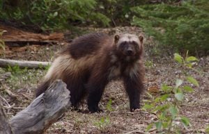
Why won’t wolverines cross the road?
In shedding light on wolverines’ aversion to roads, new research suggests the key to their conservation in Alberta
- 844 words
- 4 minutes
This article is over 5 years old and may contain outdated information.
Travel
Nine amazing summer drives we recommend

There’s nothing like rolling highway-speed over waving grasslands, beneath the bulk of mountain ranges or on the brink of oceans to sharpen your sense of the sheer size of Canada’s landscapes. At least partly because of the country’s dimensions, we’re a road-trip-loving people.
Road trips fast track us into the wildernesses between towns and cities, away from modern life for a while. They open up possibilities as plentiful as side roads to turn onto and places to park, and don’t be surprised if a sudden dramatic view of a mountain lake and the first bite from a quirky roadside food truck inspire similar gasps — adventures like these have a way of resetting our enthusiasm. The starts, stops and end points (and the driving soundtracks to play between them) highlighted for the nine drives featured here come recommended by writers with collective months of experience on the nation’s roads. But each would still push you to plan your own path, find your own pace, and maybe use the Trans-Canada Highway to string a few must-drive routes together into an even more epic journey.

Roads don’t get much wilder than the Dempster Highway. This thin ribbon of packed gravel begins just east of tiny, gold-built Dawson in the central Yukon, and winds north through succeeding waves of mountains until it reaches the Arctic Circle. From there, it crosses into the northwesternmost corner of the Northwest Territories, and drops down from the hills into the massive Mackenzie River valley. The Dempster dead-ends in Inuvik, population 3,300, a hub for the Inuvialuit and Gwich’in people of the Mackenzie Delta region.
I drove it for the first time during my first Yukon winter, and tasted both its hazards and its rewards. I watched the late subarctic sunrise light up the snow-covered mountains and the hoarfrost-covered, latitude-stunted trees; I saw caribou bounding through deep drifts on the side of the road. I lost traction on the ice-covered surface, and slid my Jeep into those same deep drifts; I hitchhiked to Eagle Plains, the only gas station along the Dempster’s entire length, to hire a tow truck to get my Jeep back out.
Most drivers visit in summer, when the daylight is endless and the biggest risk is a flat tire or two from ruts and rocks. (Bring at least one full-size spare; two is even better.) Outside of Eagle Plains — which offers a restaurant, bar and hotel rooms in addition to the service station — the highway’s amenities are limited to primitive campgrounds and roadside outhouses. There isn’t much to see along the Dempster except, well, the vast, empty land itself: the worn, ancient mountains ringed with skinny, tenacious spruce trees, the fast, narrow rivers winding away to the horizon. Blank space never looked so good.
—Eva Holland
Distance: 740 kilometres
When to go: Labour Day weekend, when the fall colour is in full swing.
Don’t-Miss Stop: Park the car and get out for a hike in the glorious Tombstone Territorial Park.
Soundtrack: Roll north to the bluesy, rockabilly sounds of Whitehorse-based artist Ryan McNally.

What do people experience as they drive up Highway 99 from Vancouver, tracing a curvaceous coastline along North America’s most southerly fiord? Few short drives pack in the natural attractions of the aptly named Sea to Sky Highway. The views of Howe Sound, Gulf Islands and soaring snow-capped peaks leave even locals speechless. Since its refurbishment for the 2010 Olympics, the road is coated in blacktop as smooth as liquorice, eagerly swallowed by both drivers and bikers. Watch out for cars abruptly swinging into viewpoints on either side of the highway. The Tantalus Range and Paradise Valley are showstoppers.
Heading north, several provincial parks vie for your attention (and hiking boots). Few visitors can resist a pit stop to feel the spray of Shannon Falls. Or take the Sea to Sky Gondola to stroll among the peaks and enjoy a meal on the Summit Lodge viewing deck. In the shadow of the nearby 700-metre-high granite marvel known as The Chief, the town of Squamish is booming as an outdoor adventure playground, with craft beer and gourmet food trucks tempting travellers.
Shortly after the highway turns inland is Brackendale, home to one of North America’s largest congregations of wintering bald eagles. Bear in mind, we have yet to reach the shark-tooth views of Black Tusk in Garibaldi Provincial Park, not to mention the all-season wonders of Whistler. Assuming you make it beyond North America’s premier ski resort, fill up in Pemberton as the Sea to Sky morphs into Duffy Lake Road, carving through dramatic mountain passes and valleys to Lillooet. In summer, the three glacier-fed Joffre Lakes sparkle in shades of blue, and offer a rugged yet accessible hike for drivers stretching their legs.
There’s a distinct rhythm that accompanies a Sea to Sky road trip. Leaning into the meandering corners, your breathing slows, your mind wanders. It is a journey that inspires bucket-list adventures, epic conversations, shareable photographs and
deep thoughts.
—Robin Esrock
Distance: 133 kilometres from Vancouver to Whistler, 130 kilometres on the Duffy Lake Road to Lillooet.
When To Go: Views sparkle year-round.
Don’t-Miss Stops: The Sea to Sky Gondola, Joiffre Lakes.
Soundtrack: Smooth and cinematic electronica: Tycho, William Orbit or Max Richter.

It doesn’t really matter how many kilometres it is from Jasper to Lake Louise, because if you’re driving Alberta’s Icefields Parkway, you’re going to stop. A lot. You won’t encounter a single red light along highway 93 as it crosses two national parks and runs along the continental Great Divide, but the views will consume your camera’s memory and demand pull-overs.
Want a big picture view of what you’re in for? Ride the seven-minute aerial tramway for top-of-the-world views.
There are other cascading waterways along the parkway, but the powerful Athabasca Falls leaves a roaring impression as you witness the Athabasca River thundering through a narrow gorge.
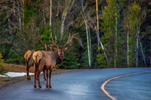
You never know what wildlife you may encounter — deer, woodland caribou, bears — but here at kilometre 38, the odds are on your side of seeing mountain goats drawn to a
roadside natural “mineral lick.” (If you packed binoculars, stop later at Coleman Creek, kilometre 131, and look for the goats at home on the cliffs).
This classic stop brings you to the most accessible glacier in North America, the Athabasca. At the massive Columbia Icefield whose waters flow to three oceans, you can take a crash course in glaciology, tour the glacier by bus and walk on ice so thick it would bury the Eiffel Tower.
Bow Summit is the highest point along the route, but the showstopper moment arrives after you walk up to the Peyto Lake viewpoint. Here aerial views of the emerald lake set against the mountains require no help from image filters.
Mountains reflected in water are a parkway signature. At Bow Lake you can see the jagged pyramid of Crowfoot Mountain mirrored in the blue waters, along with more glaciers and waterfalls.
It feels right to make your final parkway pit stop another river of ice. Named a century ago, when it had three claw-like “toes,” the Crowfoot Glacier remains distinct despite losing its lower “toe” to melting.
Can a beautiful route look better from a certain angle? Insiders say driving the parkway from the north affords both better views and better pull-offs. Start in Edmonton, a city that may surprise you with its green space and artistic adventures, and then follow the Yellowhead Highway west toward the mountains.
—Karan Smith
Distance: 365 kilometres from Edmonton to Jasper, 230 kilometres from Jasper to Lake Louise.
When To Go: While the mountains are beautiful in every season, you don’t want to miss the lakes and waterfalls in the summer.
Don’t-Miss Stop: Columbia Icefields: Get up close with ancient ice — and the effects of climate change.
Soundtrack: Big mountain music such as The Lumineers or Whitehorse.

I’ve always loved cruising the endless stretches of blacktop across Canada’s Prairie provinces, the expansive space, wall-to-wall sky and, if you venture off the Trans-Canada Highway, towns with wide Main Streets, angle-parked pickup trucks and locals doling out western hospitality.
The Red Coat Trail offers one such laid-back alternative to the Trans-Canada. So don’t expect hoity-toity accommodations and gourmet dining. Instead, think “voyage into the calm,” with few chain hotels and limited phone coverage.
Schedule three days for the 1,300-kilometre drive between Fort Macleod, Alta., and Winnipeg. As you drive east across Alberta, Saskatchewan and Manitoba, imagine passing the 275 red-coated men of the North West Mounted Police who took the law west July 8, 1874. The five- kilometre-long column of man, beast and wheeled machines must have been an impressive sight, blazing across the expanse of the Prairies.
It’s on the lonely 90-kilometre stretch along Route 13 into southern Saskatchewan that your car becomes a time machine, taking you to a place where life is slow-paced and folks are genuinely curious, ready to laugh. In Eastend, check out the T. Rex Discovery Centre, home to fossils such as “Scotty,” the first T. Rex found in the province. Poke along through small-town Saskatchewan to Carlyle and the Rusty Relics Museum, housed in a 1909-built Canadian National Railway station. A horse-mounted “Red Coat” statue stands watch in Redvers, the last Saskatchewan town on the trail. In Manitoba, leave the car and cross the recently rebuilt 184-metre Souris Swinging Bridge, Canada’s longest suspension bridge, first built in 1904. Next, “Sara,” the sculptured five-metre-high camel, represents nearby “desert” Spirit Sands outside Glenboro.
With very little traffic, the road will be yours to bask in that special Prairie magic. It’s a place and a pragmatic, friendly people defined by extremes of weather, constant wind and big space.
—Garry Sowerby
Distance: 1,300 kilometres
When To Go: Early summer, when the grasslands are in full bloom.
Don’t-Miss Stop: A short detour to explore Cypress Hills Interprovincial Park, on the Saskatchewan-Alberta border.
Soundtrack: Anything by J.J Cale and John Prine, sprinkle in some Neil Young, The Guess Who and a shot of Vivaldi’s The Four Seasons.
Wildlife
In shedding light on wolverines’ aversion to roads, new research suggests the key to their conservation in Alberta
Environment
An estimated 29 million mammals are killed each year on European roads
Wildlife
Turns out, in the City of Burlington at least, it was to have a lot of sex
Travel
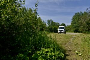
I traded my apartment for a van and discovered the freedom of exploring “The Great Wilderness” on my own schedule