Exploration
The cool calling: Glaciologist Alison Criscitiello is redefining the term explorer
She's also combining her knowledge and skills to uncover the secrets of climate change
- 2830 words
- 12 minutes
History
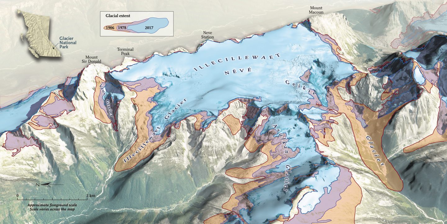
Mary Vaux’s groundbreaking 19th-century study of B.C.’s Illecillewaet Glacier created an invaluable record of the glacier’s recession
On July 15, 1913, Mary Vaux hiked through spruce and hemlock until she found the long, white snout of the Illecillewaet Glacier. She had been there many times before, observing the ancient ice form, and as she wrote to her father that night: the “signs of recession are very evident.”
Vaux was obsessed with this glacier, nestled in British Columbia’s Selkirk Mountains, and she was particularly intrigued by its nonstop contraction. In a note the next day, now archived in the Whyte Museum in Banff, Alta., she again exclaimed, “The Glacier sure is very much changed, and has receded a lot.” Finally, on her last day trudging up and over the ice, Vaux once again wrote her father. “I have had two hard days on the glacier, but the work is all done now, and everything is in order.”
What exactly was the “work” Vaux was doing, and why was it now complete? Vaux was not just admiring the blue-tinted sprawl of ice; she was on a mission. Starting in 1887, she would trek thousands of kilometres almost every year from Philadelphia, by rail, horseback, ferry and foot, until she reached the Illecillewaet Glacier (Illecillewaet was named by the local Indigenous community and referenced the river before being applied to the glacier). When she finally arrived, the work would start. For a quarter century, she studied the flow and recession of the glacier, documenting its dynamics in detail and, despite not having a post-secondary degree, publishing her findings under her own name. Hers was the first formal glacier study conducted in Canada.
The legacy of images and measurements she left behind over a century ago make the Illecillewaet one of the longest-studied glaciers in North America. At a time when women couldn’t even vote, Vaux broke barriers in a field dominated by men. Driven by curiosity, a passion for the outdoors and a belief that scientific observation of the natural world mattered, her work offers a window into the past, when glaciology was still a nascent science. Her efforts also provide a bridge to the present, where climate change has shifted our understanding of glaciers and their critical yet vanishing place in the world.

Vaux’s father was George Vaux Sr., a Philadelphia businessperson who once nearly drowned on a disastrous transatlantic crossing to Europe. Following that trip, he vowed never to attempt sea travel again and also forbade his children from making the crossing themselves. The same year that Vaux graduated from high school, her mother, Sarah, passed away, and the responsibility of housekeeping and caring for her father fell on Vaux’s shoulders, dashing any chance of university studies. When the Canadian Pacific Railway was built — carving into the recently created Glacier National Park, where the Illecillewaet sits — it brought not only a travel alternative to Europe but an outlet that nurtured Vaux’s curiosity in science, art and the outdoors. As she once wrote, “Sometimes I feel that I can hardly wait till the time comes to escape from the city life, to the free air of the everlasting hills.”
Surrounded by jutting peaks, the Illecillewaet spans six square kilometres and, from its upper end to its toe, it descends roughly 1,000 metres. In 1887, Vaux and her family visited for the first time and were spellbound by its beauty.
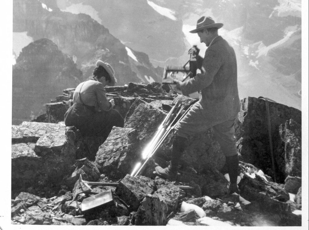
When they returned a few years later, however, they were overcome by a new feeling: astonishment. The glacier had drastically retreated. From here, these Philadelphia Quakers, who would come each year to vacation, pursued a study of the Illecillewaet that would last over two decades. Mary’s brother William, an engineer, first led the efforts, guiding Mary and her other brother, George Jr., in the proper techniques. But when William died in 1907, and George’s law practice became too busy for him to travel, the research was left to Mary, who saw it as her responsibility.
Each year, using lines of rope and large boulders as fixed points, she measured the glacial recession. In a 1911 paper published in the Canadian Alpine Journal, she wrote: “The distance from Rock C to the nearest ice was 426 feet [130 metres], thus making the recession for the year 60 feet [18 metres].” At the same time that glacial ice recedes, though, the entire mass also shifts downward — hence the common phrase “rivers of ice.” So, in addition to measuring the recession, she also measured this flow. Every year, Vaux placed specially made steel plates on the glacier’s surface and, the following year, she would hunt them down, using transit measurements to then calculate the average rate of flow. Between 1909 and 1910, according to Vaux’s calculations, the downward glacial flow rate was 3.74 inches (9.5 cm) a day.
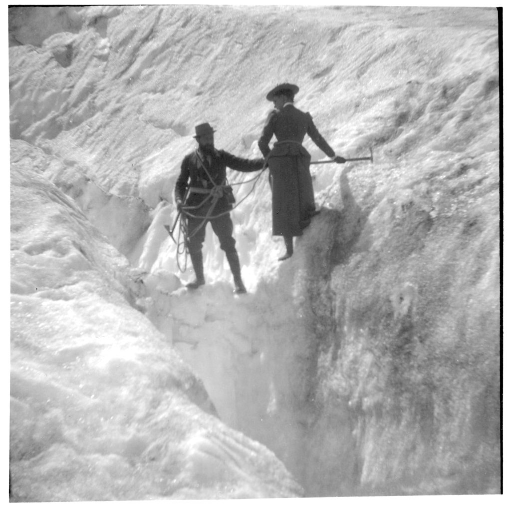
Finding these metal plates, which were painted red, could be tricky. And sometimes they went rogue. In the summer of 1910, plate #8 couldn’t be recovered, Vaux wrote, because it was “hidden by great mounds of ice, with deep crevasses between.” To make things easier for the next year, she would put the plates “in a more favorable position.”
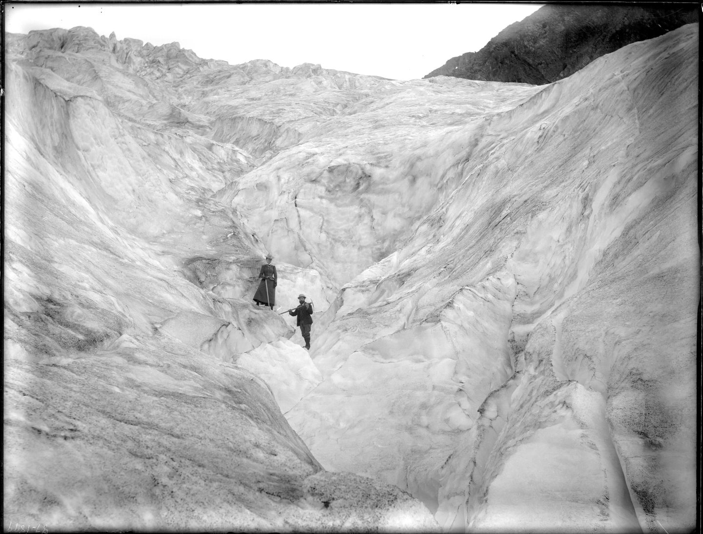
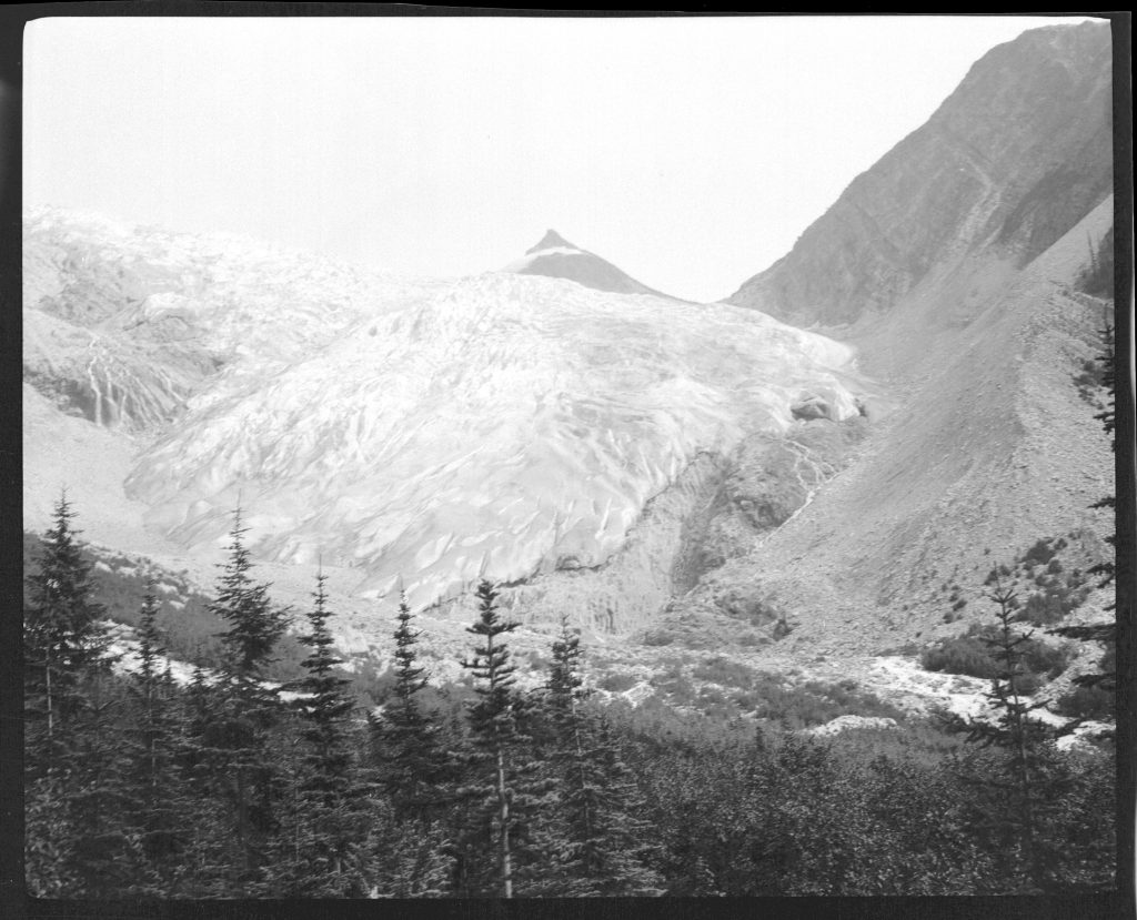
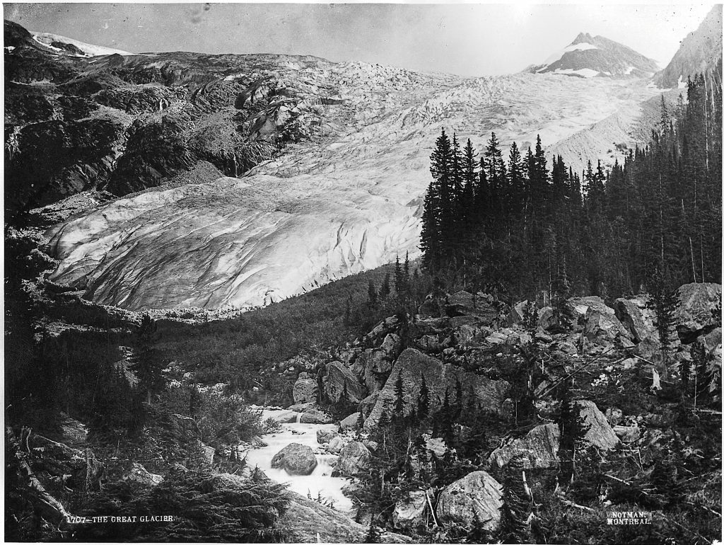
It’s hard to believe this was how Vaux vacationed most summers. Tromping over glaciers with heavy equipment and spending her days locating plates and measuring distances could hardly have been relaxing. And this wasn’t the least of it. Arguably her most valuable research was the photographs she took over the course of three decades. She used a cumbersome 19th-century camera weighing in at nearly 45 kilograms; it required two pack horses to slog gear up the mountain slopes. Like the way she used fixed-point rocks, she also used fixed-point camera locations, returning to the same spots each year to capture the glacier; the photos, gauzy and faded, showed the ice inexorably receding and the white tongue withdrawing up the valley.
It’s these photos, contrasted to those taken a century later, that provide remarkable documentary evidence of the Illecillewaet’s retreat.
Each generation, humans decimate great swaths of forests and pull mountains of fish from the seas. And for the next generation, a new normal sets in: smaller trees, fewer fish. This is known as “shifting baseline syndrome,” where successive generations know only what they have, forgetting what once was. Photography can be a powerful check to this collective amnesia. Think images of the huge cod that grandpa once caught or the giant cedars that grandma once played in. Or from Vaux’s old pictures, images of a plump white glacier cresting the valley brim and falling to its bottom — nearly two kilometres longer than it is now — help remind us how much has changed.
And yet, pictures can disguise more complicated stories. They tell us what we see but not always why we see it. The late 1800s was the age of the amateur, a time when non-professionals could significantly contribute to scientific advancement. Through sheer dedication and sense of purpose, Vaux and her brothers became some of the first glaciologists in North America, providing invaluable data. In the ensuing century, the knowledge base expanded — the recession Vaux captured is now better understood, which has given us a greater appreciation for the complexity of these blankets of ice.
The science Vaux conducted, with her boundless inquisitiveness and rudimentary techniques, continues to act as a key baseline and provide invaluable insight.
We depend on glaciers in myriad ways. In some parts of the world, like northern India, farmers irrigate their crops with glacial meltwater. In the Andes, countries like Peru and Colombia rely on this water for hydropower. In the Selkirk Mountains, glacial water helps regulate the temperature of rivers, an important component for the spawning success of many fish species. Around the world, hundreds of millions of people rely on glacial melt for their drinking water. Our societies are enmeshed in the hydrological cycle in which glaciers play an integral role. For humans in North America, there was never a time when glaciers were not part of the landscape.
For the past two million years, colossal swaths of ice expanded and contracted across North America. The peak of the last major glaciation was around 20,000 years ago, when most of Canada was covered. The ice reached as far south as Cincinnati, Ohio, and in some areas was almost four kilometres thick. Think of the ice wall in Game of Thrones, but higher. When these massive glaciers eventually melted away, it enabled the First Peoples to travel farther and flourish throughout much of the continent.
As the glaciers advanced and retreated, they warped and denuded the landscape, scooping out deep valleys, moving giant boulders and sculpting sharp mountain ridges. During the last major melt, glacial meltwater filled up sea-like basins to form the Great Lakes. Since then, a set of shorter warming and cooling periods occurred, with glaciers expanding and contracting at a smaller scale. At the end of the 19th century, when Vaux measured the retreat of the Illecillewaet Glacier, she witnessed the melt after one of these shorter, cooler stretches, sometimes called the Little Ice Age.
But how does the retreat she recorded square with climate change? Is the melt we see today simply a continuation or is it caused by the greenhouse effect? In the period when Vaux hiked over moraines and cerulean-tinged ice, only about 25 per cent of global ice loss from glaciers was linked to anthropogenic causes. Today, it’s closer to 70 per cent. “We find unambiguous evidence of anthropogenic glacier mass loss in recent decades,” noted a 2014 paper in the journal Science.
In other words, while Vaux witnessed a historic glacial recession mixed with human-caused impacts, the human signal — or “anthropogenic forcing,” as glaciologists put it — is today much stronger. Humans are unequivocally heating the planet, and, like ice cubes on a summer sidewalk, our glaciers are disappearing before our eyes. This brings many consequences, including the rivers of excess glacial meltwater now flowing into our oceans and raising sea levels.
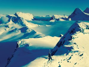
Similar to many of the 200,000 other rapidly melting glaciers around the world, the Illecillewaet is shrivelling. On a sunny summer day, I decided to visit the Illecillewaet and witness these changes first-hand.
Travel with us
Vancouver to Whistler Cultural Hiking Journey
From Vancouver to the world-class mountain town of Whistler, this one-week itinerary focuses on the region’s natural wonders and Indigenous experiences. Featuring some of Canada’s best hiking trails, the Coast Mountains are the perfect place to enjoy the best that nature has to offer.
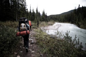
Glaciers spark our imaginations. Like monasteries atop mountaintops, alpine glaciers such as the Illecillewaet force visitors to embark on winding pilgrimages for a closer look. About one hour from the town of Revelstoke, I pull off the Trans- Canada Highway to hike to the Illecillewaet Glacier. I plan to climb up the “Perley Rock” trail and, after a few hours, hopefully, reach the receding ice above.
I am soon immersed in the forest, where large hemlocks reach over meadows of pink fireweed and purple subalpine daisies. There’s a sweet smell in the air. And not long into the hike, my senses are overwhelmed by the loud rush of a mountain stream tumbling through the forest.
Still in the trees, before the steep switchbacks ahead, I pass a fit couple wearing exercise gear. The man’s hair is held back by a headband and they both wear sunglasses and wide grins. I ask in passing how the hike was, and the man gives the “chef’s kiss” gesture before declaring it was probably the best hike they’ve ever done. High praise indeed.
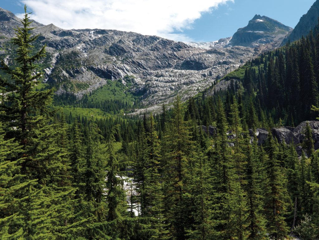
About an hour later the path turns into a gruelling set of zigzags up a steep, rocky slope. I am now above the tree line, where the sun beats down with glowing intensity. The air is warm, and I soon stop to look behind me. I am high up now, surrounded by mountain peaks, blue skies and drifting clouds. Below me, I can see the stream far away, a thin white line cutting through the valley. There is a soft silence in the air.
Over 100 years ago, in Vaux’s day, looking ahead I would have also seen the entirety of the glacial tongue before me, but what exists now is rough rock the glacier has retracted over. The rock is dark with faint streaks of red running through it and a series of parallel striations etched along the surface, as if a giant metal rake has been pulled across it.
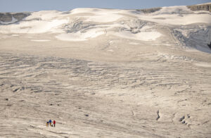
After traversing a collection of snow patches on a steep hill, I ascend what feels like the last hump before a plateau; and then, in the distance, I see a small rock cairn, and beyond it the striking white brushstroke of a distant glacier.
Some time later, after cresting the final ridge, the toe of the Illecillewaet is before me. It stands at the end of a wet, mucky terrain a few hundred metres away, where rivulets of water meander towards the cold bulky mass. The air is now crisp. As I get closer, I can see how high the terminus is — it looms perhaps 20 metres above. Midway up this ice wall are several small holes where, like the bilge of a large boat, water spouts out and falls down into a silty turquoise pool. A low rumbling sound emanates from within the glacier, along with the odd creaking noise like a tree trunk groaning in the wind.
I clamber up another ridge to get a wider view. This different angle brings a new perspective: a gentle smattering of colours on the ice. Some areas are tinged with a subtle red. It’s called “watermelon snow,” the result of a red-pigmented algae leaving a rosy tint. For the most part, the glacier is a frozen white spread with hints of blue, but there are also faded patches of black dusted on the surface, the residue of volcanic eruptions and forest fires blown across the world or pollution spewed from cars and coal-fired power plants. These black patches absorb the sun’s heat and accelerate the melt.
Every area of study is often reduced to its most known or iconic association. For glaciers, it’s climate change. And fair enough — it’s such a clear and visible link to make. But the story of glaciers is far more complex. Humans have lived in proximity to them for millennia, traversing among these crystal terrains to find food and perhaps new lands. Glaciers inspire awe. They shift, relentlessly, cracking and cleaving; they slide, surge, grind and recede. They contain life. They are also powerful vessels for inquiry and learning.
Like doctors conducting yearly physicals, glaciologists have returned to the Illecillewaet for over 130 years since Vaux’s first trip. Through this time, our knowledge of glaciers has expanded along with the technologies needed to acquire it. What’s equally fascinating is how the science Vaux conducted, with her boundless inquisitiveness and rudimentary techniques, continues to act as a key baseline and provide invaluable insight.
The work Vaux and her brothers started in the late 1800s launched the first continuous, detailed study of glaciers in Canada and was recognized soon after by the Commission Internationale des Glaciers. But by the 1920s, the photos and measurements largely stopped. The CPR train track that brought visitors near the glacier was diverted to another mountain route, restricting access to the Illecillewaet. Then came the First World War and the Great Depression, and, during these cataclysmic events, only sporadic measurements were done. Not until 1945 — over 30 years later — would researchers from the federal government’s Dominion Water and Power Bureau continue the type of consistent measurements Vaux had conducted. The bureau collected this data from 1945 to 1960, and then Parks Canada continued the research in 1972.
Scientists now had long-term empirical proof of the Illecillewaet’s recession. And in the mid-1980s, almost 100 years after Vaux first visited the glacier, her family’s work was used to assess the glacier’s total retreat. A paper in the Annals of Glaciology analyzed Vaux’s measurements through to those conducted by Parks Canada and found the glacier’s net retreat over almost a century, between 1887 and 1984, was a staggering 1,433 metres.
Indeed, Vaux saw her work as a baseline of data to build upon, purposely avoiding the deduction of new theories. “It is only by careful and accurate observations covering a series of years,” she wrote, “that the facts can be learned by which theories may be crystalized.” Over the decades, her scientific work would be referenced in Nature, the Annals of Glaciology, the Canadian Alpine Journal, the International Journal of Remote Sensing and Arctic, Antarctic, and Alpine Research.
Today, when cameras can be carried in pockets rather than on mules, Vaux’s glacier research is still being used. In a 2003 paper published in Arctic, Antarctic, and Alpine Research, scientist Daniel McCarthy used Vaux’s images to estimate the age of lichens at the Illecillewaet base. The positions of the glacier at specific times, he wrote, “are based on maps and photographs by the Vaux family.” At the end of a long day on the glacier, it was mainly Vaux who developed the images using a hotel closet converted into a darkroom.
A lot has changed in how we observe glaciers. While we once used rocks, ropes and cumbersome cameras, we now use planes, satellites and supercomputers. And while Vaux once measured the recession of the toe, scientists can now study indicators like the thaw rate, surface area and changes in glacial mass.
Combined with modern knowledge of our heating planet, these new methods reveal a worrying story. In a 2017 Parks Canada study, modern satellite images were compared with aerial photos from the 1970s, confirming that the area of ice in Glacier National Park had declined by 36.6 per cent.
The melt is also accelerating. In a recent study in Nature, millions of previously untapped NASA satellite images, taken over two decades, were used to gauge the extent of glacier loss globally. A supercomputer ran continuously for an entire year to analyze the trove of images and crunch the numbers. One alarming finding: between 2000 and 2019, the thaw rate of western North American glaciers, which includes the Illecillewaet, increased fourfold.
Another key indicator of a glacier’s health is its “mass balance.” In essence, glaciers expand and contract with the seasons, with the summer melt and the winter snow, and it’s this net change in seasonal loss and accumulation that helps to determine their mass balance. It can be measured from either planes and satellites or on the ground. Surprisingly, despite all the high-tech gadgets available, on-the- ground surface measurements are often the bread-and-butter of many glacier studies, providing more localized data. Like the accelerating thaw rate and the shrinking surface area, the Illecillewaet’s mass balance looks equally dreary. A report by Parks Canada found the glacier’s net mass balance, between 2009 and 2017, was negative, and the glacier’s overall condition was deemed to be “poor” and “declining.”
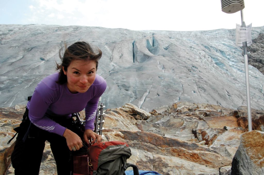
As it turns out, like Vaux’s upward slog with mules and camera equipment, these mass balance measurements are gruelling to conduct. Jocelyn Hirose, a Parks Canada scientist, conducted mass balance research on the Illecillewaet as part of her master’s thesis a decade ago. Hirose spoke to me about her physically demanding research, her love of glaciers and the inspiration she gained from Mary Vaux.
Born on the flat plains of Manitoba, Hirose, now 37, was drawn to the mountains after a family hiking vacation in the Rockies when she was a child. On a later trip in university to hike Kilimanjaro, in Tanzania, she was unnerved to see that a popular ice-climbing route was closed due to a lack of ice (it’s estimated the ice on Kilimanjaro could disappear by 2040). Following an environmental sciences degree at the University of Winnipeg, she enrolled in a master’s program at the University of Calgary to study glaciology and spent the next several years near the border between B.C. and Alberta, scouring every edge of the Illecillewaet Glacier.
As with many master’s theses, Hirose’s homed in on a small and specific part of a larger puzzle. She wanted to understand the contribution of meltwater from the Illecillewaet and nearby glaciers into the local river basin. And because the Illecillewaet sits in a particular mountain climate — with higher precipitation compared to the nearby Rockies — the data would better help future scientists understand and model the area. Part of Hirose’s meltwater study included mass balance research, which involved Hirose drilling large metal poles into the Illecillewaet — in high areas where the snow accumulated and in low areas where it melted. Throughout the year, she would check the rise and fall of the glacier’s surface against these drilled poles.
The work involved camping on the glacier. A helicopter would drop off camping gear on the ice surface, and throughout the year, Hirose would ski and hike up the face, collect data along the way, stay overnight and then ski down afterwards. One summer she went up and down the glacier at least 30 times. “I think I’ve never been more fit than that summer,” she says. Hirose spoke of skiing up in metre-high snow, through torrential rains and white-out blizzards, “not knowing up from down.” Once, she fell down a crevasse and had to climb out with help from a friend she was tied to by a rope. Another night, she stayed through a lightning storm. “It was beautiful though,” she says, “I got to see the lightning come from way down the valley and up to the glacier.”
The popular image of scientific endeavour is often a man in a white lab coat, in a sterile laboratory, hovering over an Erlenmeyer flask. Of course, it also involves a woman camping on ice sheets to collect data while thunder and lightning crackle and flash around her. Behind the headlines — glaciers melting, ice receding — there are those like Hirose skiing up and down the ice to observe and analyze their relentless transformation. To understand how the warming world affects these towers of ice, it takes demanding work, but this research brings greater clarity: about the rate of melt, the water supply, future projections and impacts on irrigation and ecosystems. Glaciers can also reveal the history of climate change. On deep ice sheets, in polar regions and in Greenland, glaciologists dig up ancient ice cores to analyze carbon dioxide concentrations, confirming that, yes, they’re at the highest level in the past million years. All this hard-won scientific data helps shape and reinforce our cultural, political and technological response to what many consider the greatest challenge of our time.
Both Mary Vaux and Jocelyn Hirose have deep wells of an attribute vital to scientific thought: curiosity. While spending so much time on the Illecillewaet a decade ago, Hirose says she immersed herself in Vaux’s story and was inspired by the pioneering woman and her curiosity and commitment. “She had a scientific and creative thought process,” Hirose says, and she wanted her time in the mountains to be “meaningful beyond just doing mountaineering. … She was a female ahead of her time.”
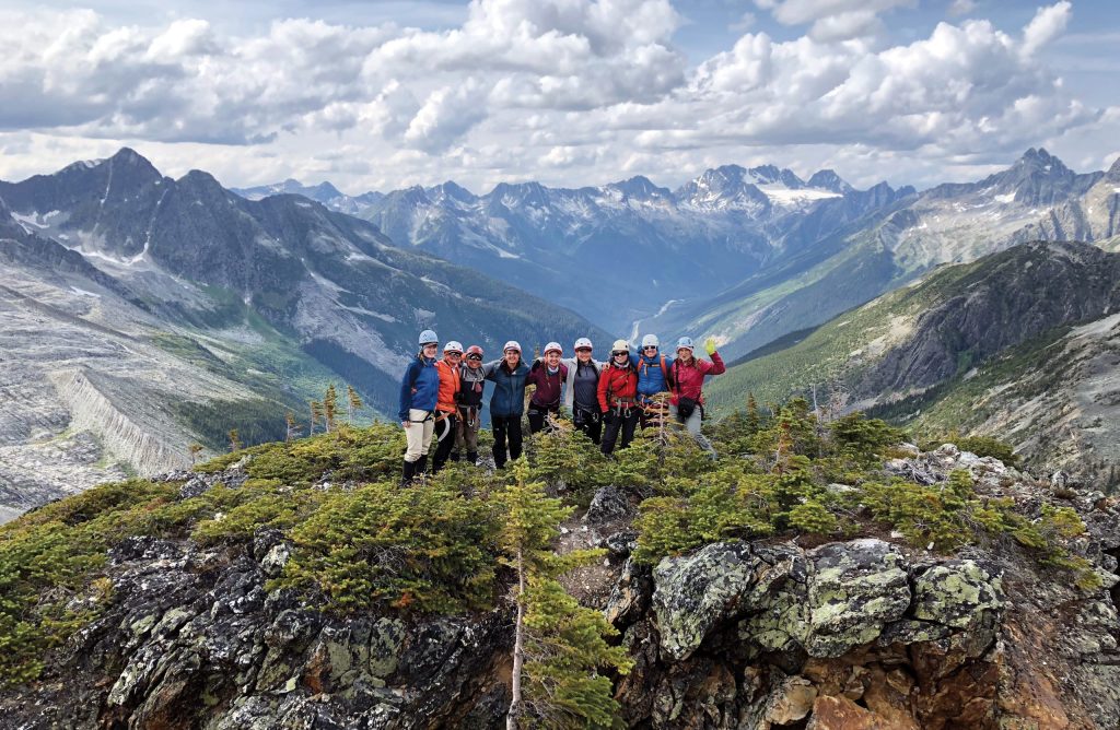
After her own experiences on the Illecillewaet, Hirose, now a mother of two, has committed to developing scientific curiosity in the next generation of young women. With friends and fellow researchers Eleanor Bash, Alison Criscitiello and Cecelia Mortenson, in 2018 she co-founded Girls* on Ice Canada, an organization that takes teenagers on 12-day scientific expeditions on the Illecillewaet and another nearby glacier. While there, they practise leadership and mountain skills while exploring the alpine environment. They also develop their own scientific questions and do field experiments.
On the same glacier Mary Vaux studied, these young women map the dynamics of glacial flow, examine layered crevasses and sample “watermelon snow” before analyzing it under microscopes. During the expeditions, Hirose says she sees many teens develop confidence and leadership qualities after first arriving shy and uncertain. “It’s so beautiful to see the confidence boosted in each of these girls through the whole 12 days.”
Vaux’s legacy of research, propelled by interest and maintained through dedication, has laid a scientific cornerstone for the work that continues now. It’s a slice of observation in a larger planetary puzzle of geologic time and climate change.
While major glacial shifts took millennia, climate change is shaping our landscape at a shocking speed. A 2015 study in Nature Geoscience found that, by the end of the 21st century, 70 per cent of glacier ice in British Columbia and Alberta could disappear, bringing profound implications for water quality, sea levels, local ecosystems and power supplies. The Rockies could lose up to 90 per cent of their glaciers.
Many of the extraordinary vistas Vaux once experienced will have to be shown to future generations through photographs — snapshots of a cryosphere that once was. If anything, this bleak thought should give us immense pause. It should also reinforce the urgent need — through effective climate policies — to lessen the disastrous impacts.
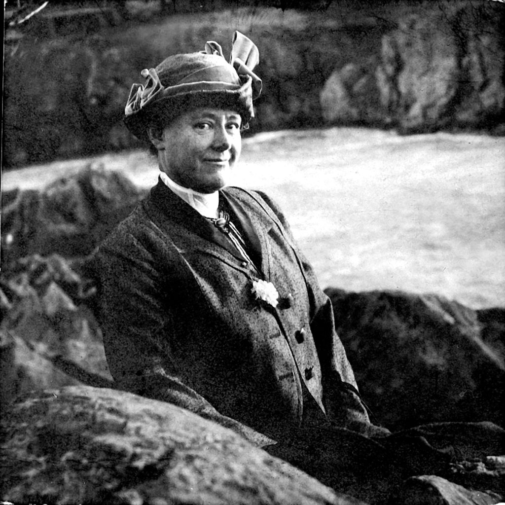
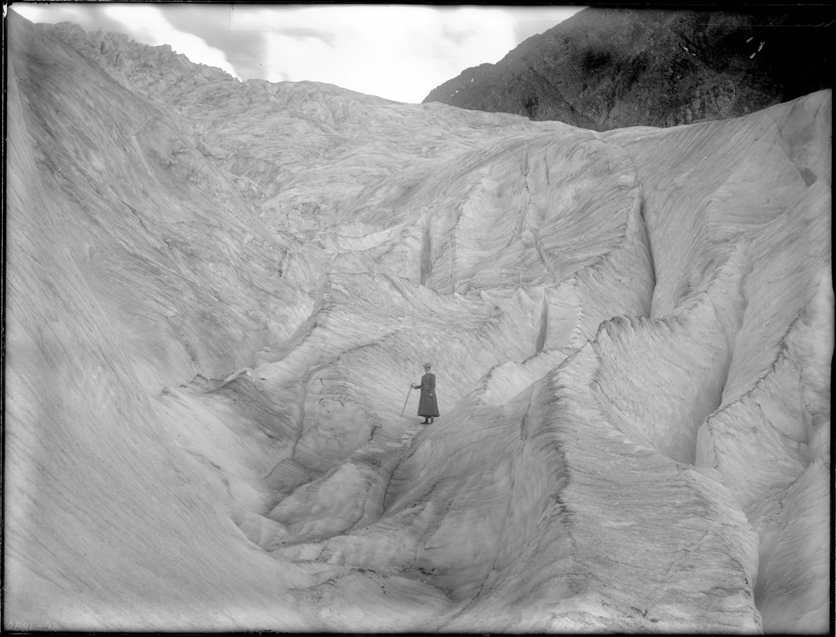
There is one glacial image, different than most, that uniquely blends author and subject. It’s an iconic photograph of Vaux visiting the toe of the Illecillewaet, clad in a dark hat and a long black dress and holding a large wooden walking stick. The sloping and crevassed glacier towers above, a section now long-melted away. The image is striking both for its scale and the antiquated style of dress she is wearing, symbolic of the era; and with a thick mountain of ice rising into the sky, Vaux and the Illecillewaet are frozen in time.
This story is from the July/August 2022 Issue
Exploration
She's also combining her knowledge and skills to uncover the secrets of climate change
Exploration
A journey of friendship, loss and healing in the footsteps of early 20th-century mountain explorer Mary Schäffer Warren
Environment
What vanishing mountain glaciers mean for river flows, groundwater and the millions who depend on them
History
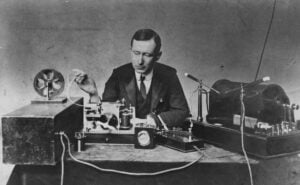
A dive into the fascinating evolution of radio, starting from the first received message at Signal Hill, Newfoundland