This article is over 5 years old and may contain outdated information.

People & Culture

Exclusive: Adam Shoalts on his epic Trans-Canadian Arctic Expedition

Explorer Adam Shoalts, who completed his monumental 4,000-kilometre journey on September 6, speaks to Canadian Geographic about an expedition that calls to mind the likes of Vilhjalmur Stefansson and Joseph Tyrrell
  • Sep 13, 2017
  • 2,702 words
  • 11 minutes
Adam Shoalts, Arctic, explorer, expedition, North, wildlife, canoe, RCGS Expand Image
Advertisement

When Adam Shoalts talks about travelling solo, he doesn’t mean in the “I backpacked across Europe to find myself” sense. The modern-day explorer and author of the bestselling book Alone Against the North: An Expedition into the Unknown (about a previous expedition into the Hudson Bay lowlands) just crossed 4,000 kilometres of remote, Arctic mainland Canada with no one to keep him company but the wolves and bears bold enough to investigate him and his canoe.

Here, in his first interview since embarking on the four-month, Royal Canadian Geographical Society sponsored Trans-Canadian Arctic Expedition, Shoalts reflects on his journey across one of the world’s vastest remaining wildernesses.

Expand Image
Adam Shoalts’s Trans-Canadian Arctic Expedition route. He departed Old Crow, Yukon, on May 13, reaching Baker Lake, Nunavut, on Sep. 6. (Map: Chris Brackley/Can Geo)
Expand Image
Shoalts holds the Compass Rose Flag of the RCGS in the eastern Arctic on the final day of his Trans-Canadian Arctic Expedition. (Photo: Adam Shoalts)

On the dangers of solo expeditions

This is something that isn’t immediately apparent from looking at an expedition map: you’re constantly confronted with important, stressful decisions, and you don’t want to make a wrong decision. Like, “Is it safer to stick to shore, or do I cut across this bay?” If you stick to the shore continuously, 1,000 kilometres turns into 3,000 kilometres; there are so many inlets, islands, bays, peninsulas. So how much open water is safe to cross in a 4½-metre canoe? One kilometre? Three? Five? Ten? These can quickly turn into white-knuckle crossings, especially when you’re getting one day of calm weather in 10. I got really good at reading the weather and shifting wind, feeling it on my cheek.

So I always erred on the side of caution, tried to avoid open-water crossings of more than three or four kilometres. And when I had to cross the really big bodies of water, I approached them Viking-style (a mini version of it) by island hopping. Even if I was marooned until the high winds and white caps died down, at least I’d be on a bit of land. I had days in the Eastern Arctic like that, where winds pinned me down. Even portaging was impossible. I would flip the canoe over and cover it with heavy rocks, because one of my greatest fears was waking up in the morning to see that it had blown away, a red speck across the lake.

Expand Image
Making camp in the northern Yukon, late May. (Photo: Adam Shoalts) 

On isolation and the odd human encounter

The only other canoeists and campers I met along my entire route came in just three parties — groups of 12, eight and six — all of them within three days of one another in late July, and all doing the same route down the Coppermine River. All of them, I think, thought I was crazy for trying to go upriver on the Coppermine, and for going alone. 

Other than those parties, I saw a few motorboats on the Mackenzie River and a handful of fly-in fishermen on Redrock and Point lakes in the eastern Northwest Territories. There were also, of course, the bush pilots who resupplied me on two occasions. For around a month at the start of the expedition and for a month near the end I didn’t see a single soul — unless you count a human skull on the tundra, somehow disturbed from its grave. That first month was the hardest of the two, but you just try to stay on an even keel and limit how much time you spend talking to yourself. I drove myself really hard and made incredible time — way better than I’d dared hope — waking up at 4 a.m. and travelling continuously. Many days I canoed for 12 hours and didn’t break until it was time to make camp: get to shore, unload and set up the tent, cook quickly, sleep, and then do it over again. That frantic pace and routine seemed to lessen the psychological effects of isolation. 

Expand Image
Expand Image

On wildlife sightings and close calls

The scariest wildlife moment in four months was actually because of a muskox. They generally seem like harmless, gentle giants, and I saw herds of 30 or more, but this one terrified me. It was a huge bull, easily 400 kilograms, that woke me up at 4:30 a.m. with his bellowing, snarling snorts. I unzipped my tent, thinking it would be grazing nearby, but he was making eye contact with me from just a few metres away, in a pose that said he was ready to charge. I slowly, quietly zipped up my tent and put my lifejacket on, so at least psychologically I felt as though had some kind of protection. He eventually backed down.

I got beautiful footage of Arctic wolves. They would cock their heads and stare, trying to figure me out. Many would follow along shore, including the mother of a family of cream-coloured wolves. The father had been standing like a sentry, and spotted me drifting by. The mother and their three pups appeared around the next bend, and as if they’d practiced it many times, the young all dove out of sight to hide in the Arctic willows. The mother followed me along shore for about 400 metres, howling and growling warnings. I had so much admiration for her and the rest of her family.

Some days I would see five or six grizzly bears. Especially in the Western Arctic, their tracks are everywhere. You read in manuals to avoid camping in areas where there are bears, but you simply cannot avoid it in these places. Grizzlies run as soon as they see or hear you. On the whole journey, the only bear that was aggressive was a black bear. They seem generally more willing than the other species to come into your camp and steal food. In June when I was on the bank of the Hare Indian River, N.W.T., where there’s black spruce and underbrush, I heard crackling and branches breaking outside my tent. This has happened many times on past expeditions, and yelling inevitably scares away whatever is outside. But this time, when I opened my screen to check, there was a black bear staring right at me. It was pretty intimidating, because he didn’t even flinch as I yelled at him. 

I had done everything to discourage bears visiting my camp — even to the point of moving my food barrels 100 metres downstream, burning off all food residue and keeping a rotten, wet log smouldering, because bears don’t like smoke. The encounter got to the point that I had to fire a bear banger right at him, but he still did not back down. That’s when I stood up, grabbed my paddle and made my most menacing roaring and screaming sounds while I banged the paddle on my canoe. He growled at me through all of it, and then very slowly, without turning tail, walked away downriver. I had to force myself to go back to sleep, saying, “You won’t succeed on this expedition without sleep. Every night could be like this, and you will never make it if you don’t sleep.”

Expand Image
Advertisement
One of Shoaltss more constant travelling companions — the Arctic wolf. (Photo: Adam Shoalts)

On racing the changing seasons

My constant mantra was “winter is coming, winter is coming, winter is coming.” I had to remind myself of that a lot, saying it aloud whenever I saw geese flying south or when the Arctic willow and bearberry leaves started turning red and yellow in August. I’ve done expeditions in the Arctic before, I’ve been through snowstorms in July and August, and there’s no way of knowing when the weather is going to turn too nasty to keep going. I was racing as fast as I could go.

Up until the end of July, I had essentially 24 hours of daylight. From August onward I started seeing longer and longer nights. I remember the night I saw a star for the first time in three months. It was so bright, it was astonishing.

On the most difficult stretches

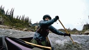
The long upriver journeys were among the most extreme aspects of the expedition. I made four major ascents: on the Mackenzie River, from the little Indigenous community of Tsiigehtchic to Fort Good Hope, N.W.T.; on the Hare Indian River to its headwaters northwest of Great Bear Lake; on the Dease River, N.W.T., to Sandy Creek, near the Nunavut border; and then soon after that on the Coppermine River, which crosses from the Northwest Territories into Nunavut and then back again. Many told me beforehand that much of this would be humanly impossible — especially the Coppermine, a huge, powerful river with strong currents, whitewater rapids, canyons and waterfalls. But I had researched my route incredibly thoroughly, and at any given time I was carrying as many as three or four trip logs from previous explorers and canoeists, ranging in date from the 18th century to 2009. The first day on the Coppermine was a brutal slog, and at times the only way to make progress was by wading along the river’s edge, through whitewater and over rocks and boulders, which was so, so taxing. There was one canyon in particular that I had to portage around four times, once with the canoe, twice for the food barrels and again for my backpack.

Traversing Great Bear Lake was another great challenge. Ice cost me several days. There was so much that my path was completely blocked and I was stranded on an island for two nights. I tried pushing it aside, breaking paths through with my canoe, but even though it was early July, the ice was more than a foot thick. It became navigable a few days into the month, and despite the fact that I had been stopped, I traversed the lake much faster than I had planned. It was scary at times, with big waves and fierce, gusting winds, but it was still a nice experience after having spent the last 600 kilometres travelling upriver, not really getting anywhere by paddling. It was like reaching an ocean. To avoid the bad wind conditions, I would sometimes wake up before 2 a.m. and paddle through the night — which was still very bright — before the winds set in again.

My philosophy is that you have to be prepared for the worst, to not take anything for granted. That meant that I was consistently ahead of my schedule.

Expand Image
Shoalts drags his canoe against the current on the Hare Indian River, N.W.T., in mid-June, seeking a route into Great Bear Lake. (Photo: Adam Shoalts)

On reviving an old technique

There were many places on the expedition where I found success by polling. For centuries, that’s actually how many Indigenous people and voyageurs travelled when it was called for, pushing themselves along the river bottom with three- or four-metre-long poles. You have to stand up in your canoe, which requires good balance — almost like a Venice gondola — but when it comes to travelling upstream, you gain much more momentum than you would otherwise. That’s how I made it up most of the Mackenzie River.

Expand Image
Shoalts polls through ice near the shore of Great Bear Lake, N.W.T. (Photo: Adam Shoalts)

On crossing paths with the greats

The Dease River was, starting around the 1830s, part of the route traders and explorers used to get from Great Bear Lake to the Arctic Coast, so I had with me the reports of explorers Thomas Simpson, Peter Warren Dease, John Rae, Vilhjalmur Stefansson, John Hornby and more … I went down to the ruins Fort Confidence, where Rae had stayed during his mid-1800s searched for Sir John Franklin, and I also followed parts of the expedition route of the legendary David Hanbury, who is remembered for his excellent relationship with the Inuit, as well as the paths of Joseph Burr Tyrrell and his brother James, Samuel Hearne and Alexander Mackenzie, to name a few.

But none of them were travelling solo. There is, however, one almost unknown explorer named Hubert Darrell — whom I would consider one of the greatest in North American exploration history — who rarely used canoes and almost always travelled on foot, and often in the winter. No one has ever written a book about him and he doesn’t even have a Wikipedia page, but when he’s mentioned in the journals of celebrity explorers like Hanbury, Tyrrell and Stefansson, he sounds practically superhuman. He vanished without a trace in 1910, at the age of 35, somewhere near the Anderson River in the Western Arctic. There were later reports, carried back to Hudson’s Bay Company posts, of strange carvings in trees, and it was speculated that he might have left them as messages.

Of course, the Dene people also travelled solo and on foot, often for thousands of kilometres. They were extremely good at building canoes, but used them more for crossing rivers, because there are no birch trees for hundreds of kilometres across the northern landscape and canoes required daily repair and rebuilding from punctures caused by rocks. Voyageurs used to carry huge amounts of surplus birch bark to perform these fixes.

Expand Image
Expand Image

On reaching the end

It was bittersweet to finally pull around a point to see Baker Lake and its modern buildings made of steel looming like a mirage on the tundra. I hadn’t seen a town for months — the last had been Fort Good Hope, N.W.T., on the Mackenzie River on June 11. On one hand, I was relieved to have made it through the journey and to feel the stress and anxiety that comes with a solo canoe expedition lifted, to go home to Sudbury to see my fiancée for the first time in four months — and to have a shower and take scissors and a razor to my beard. The last bath I had was on August 11, in a lake, and after that it was simply too cold to do that again.

On the other hand, it was hard to leave the routine of the expedition, and I didn’t want it to end. I feel a bit like I’m suffering withdrawal. That had been my life for months, and I truly love the wilderness.

Expand Image
Stepping ashore at Baker Lake, Nunavut, on September 6, the expedition’s end. (Photo: Adam Shoalts)

On the value of an unbroken, wild North

Canada’s Arctic wilderness is irreplaceable, and there’s tremendous pressure to develop the North — especially for mining — that we have to approach with great caution. If we lose even parts of this wilderness, we lose an essential part of what makes Canada “Canada” and our own heritage. Once it’s gone, it’s gone. It’s amazing to think that in our own backyard, so to speak, we still have a wilderness where wild animals roam free as they always have. This is less and less true of Africa, of the Amazon, of Siberia, of Southeast Asia — the only exception of this magnitude, perhaps, is Antarctica. As Canadians, we have a special weight on our shoulders to protect this, both for us and for the whole world.

This is the 150th anniversary of Canada’s Confederation, but rather than celebrating that part of the past, I wanted my journey to be about looking ahead to the future. I hope it makes Canadians consider what the North will look like in a century and a half. We need to think long-term, because otherwise all we’ll save is pockets of parks here and there, and parts of the North will have gone the way of the Great Plains.

Crossing more than 4,000 kilometres of Arctic wilderness has left me convinced, more than ever, that the Canadian wilderness is precious. Regardless of what part of the country we live in, we have to cherish it, because there’s nothing else like it on the planet. That is an astonishing thing.

Expand Image
Shoalts paddling his Nova Craft canoe upriver on the Coppermine, Nunavut, July 22. (Photo: Adam Shoalts)

Advertisement

Are you passionate about Canadian geography?

You can support Canadian Geographic in 3 ways:

Related Content

People & Culture

On thin ice: Who “owns” the Arctic?

As the climate heats up, so do talks over land ownership in the Arctic. What does Canadian Arctic Sovereignty look like as the ice melts?

  • 4353 words
  • 18 minutes
CAE ships anchored at Bernard Harbour, Nunavut, in 1914

Exploration

Canada’s unsung expedition

A century after the start of the thrilling expedition that strengthened claims to Canadian sovereignty in the Arctic, the first Canadian Arctic Expedition remains a largely unknown part of the country’s history

  • 1956 words
  • 8 minutes
Montréal is taking great strides to reinforce its image as the “most bike-friendly” city in North America

Environment

Clean commute

Canada's largest cities are paving the way for more eco-conscious commuting choices

  • 3352 words
  • 14 minutes
Arctic Frontiers conference 2019

Environment

Five key takeaways from the Arctic Frontiers conference

The uncertainty and change that's currently disrupting the region dominated the annual meeting's agenda

  • 2651 words
  • 11 minutes