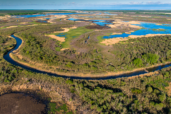
After flowing some 1,200 kilometres from Canada’s Rocky Mountains, collecting runoff from the Prairies and Boreal Plains, the Saskatchewan River spills into a maze of channels that cut across the low-lying forests and wetlands of the Saskatchewan River Delta.
At 10,000 hectares, it’s the largest inland delta in North America, and prime habitat for diverse wildlife, including one of the continent’s most important regions for migratory birds. It’s also part of Canada’s vast boreal forest, an ecosystem that stretches across the continent and soaks up so much carbon emissions it’s been called the northern lungs of the planet.
The delta and surrounding region in eastern Saskatchewan is one of several priority planning areas for the Canadian Boreal Forest Agreement (CBFA)—an ambitious pact signed in 2010 by six environmental groups and 18 forestry companies, the latter all members of the Forest Products Association of Canada.
Getting those former foes together at the same planning table was difficult enough, but it pales in comparison to the complex task of protecting and sustainably managing more than 73 million hectares of public lands—an undertaking that will take years of intensive work for full implementation.
The CBFA’s collaborative work in the delta is a case study in the importance of large-landscape planning. Although CBFA’s Saskatchewan planners are focused on the Pasquia Porcupine Forest Management Area—a 2-million-hectare region co-managed by CBFA industry signatory Weyerhaeuser—environmental and economic impacts can be traced much further west.
Starting as snowmelt in the jagged peaks along the Continental Divide, the water that flows into the delta is the lifeblood of the many communities and industries in the Saskatchewan River basin. And all that activity upstream, including extensive irrigation and multiple hydro dams, leads to major effects downstream.
“It’s astounding the impact the rest of us have on the delta,” says CBFA planner Gord Vaadeland, executive director of the Saskatchewan chapter of the Canadian Parks and Wilderness Society (CPAWS). “It’s similar in scope to the Colorado River, when you look at cumulative effects.”
The Saskatchewan planning team includes environmental groups CPAWS-Saskatchewan and Prince Albert Model Forest, along with Weyerhaeuser and Tolko Industries, another CBFA signatory. Together, the groups aim to protect the area’s biodiversity and natural landscapes, while eschewing the ecologically destructive pattern of management that has afflicted many natural ecosystems around the world.
Although it will ultimately need buy-in from First Nations and local and provincial governments, the plan they’ve proposed would ensure larger protected areas in the upland part of the delta and in the Mossy River watershed that flows into it. The plan would also protect endangered woodland caribou by prohibiting logging on any lands where the species is concentrated, and by preserving buffer zones around those areas to increase wildlife connectivity.
To create their proposals for the delta and other areas across the country, CBFA planners use a novel approach: rather than simply protecting whatever remains after industry alters the landscape, they put conservation first. That means setting aside large protected areas to ensure a healthy ecosystem over the long term, while guaranteeing sustainable resource extraction on the land that remains. Planners focus on caribou, which depend on large, intact landscapes with sufficient old-growth forest, since doing so will protect other species that depend on the same ecosystems.
In addition to these ecological considerations, CBFA signatories take into account cultural and economic factors that are important for those who live and work in the region, including First Nations people whose ancestors have existed on the land base for thousands of years.
This “whole-landscape” approach to land-use planning—designed to satisfy the agreement’s so-called twin pillars of environmental and economic sustainability—is always complex and challenging. But it’s even more so in the delta. Industrial activity throughout the Saskatchewan River basin has accelerated over the last 50 years, drastically changing the delta’s flow patterns and decimating local fish and muskrat populations. All while increasing effects from climate change threaten to complicate these issues further still, as mountain glaciers shrink and the snowmelt that replenishes the delta becomes scarcer.
Although CBFA planners have little control over these widespread environment impacts, they must consider them in planning—especially if they hope to convince local First Nations and Métis that their proposed plan will not lead to even further negative effects on the delta.
“To create effective land-use plans, you have to see the bigger picture,” says Weyerhaeuser’s CBFA planning rep John Daisley. The CBFA offers that bigger-picture view, he adds, since it considers the entire boreal landscape as an interconnected system.
Saskatchewan planners have to consider environmental impacts from across that ecosystem, but they must also be flexible enough to adjust their plans after consulting with local communities. “It all takes time,” says Daisley. “We’re working with a diverse group of individuals, who are coming at this from different points of view. We need to work until we get a consensus on these things.”


