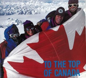
In the spring of 2021, Alison Criscitiello, the director of the Canadian Ice Core Lab at the University of Alberta, and I are teaming up to lead a group of climbers and scientists to Yukon’s Mount Logan, Canada’s highest peak. We’ll be attempting to drill a new high-resolution ice core for Criscitiello’s lab, as well as repeating historic photographs taken on the mountain’s summit plateau, so that we can explore landscape change at high altitude over time. It’s all so that we can better understand the effects of climate change on Canada’s northern mountains.
Of course, our team is climbing in the service of collaborative scientific understanding. So, at the request of Michael Schmidt, a long-time geophysicist with the Geological Survey of Canada and team leader of a 1992 Royal Canadian Geographical Society sponsored expedition that was the first to use GPS technology to establish Logan’s official height, we will also re-measure the mountain’s height.
When Schmidt’s expedition measured Logan’s snow- and ice-encrusted top at 5,959 metres above sea level (+/- three metres) nearly 30 years ago, the global positioning system — a project initiated in 1973 by the U.S. Department of Defense — was still three years away from being fully operational. Their success made their Logan summit all the more remarkable.
“[It] was no ordinary ascent,” Schmidt wrote afterward in a Canadian Geographic feature. “We were combining science with climbing and our summit bid had to be timed carefully to coincide with the position of satellites that orbited far over our heads.”
As if climbing Logan itself isn’t challenging enough.
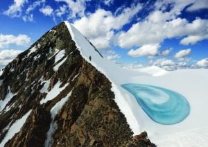
Located in Kluane National Park and Reserve in the southwestern corner of the Yukon, and within the traditional territories of three First Nations, Mount Logan stands unrivaled in physical mass — and perhaps in mountain grandeur. The massif boasts the largest base circumference of any non-volcanic mountain on Earth. Twelve distinct peaks rise above 5,000 metres from its 20-kilometre-long summit plateau. Its many saw-tooth ridges rake moisture from the almost countless, year-round storms produced over the Pacific Ocean. Average summer temperatures on the summit plateau hover around -27 C, and tremendous snowfall in the area produces an area of glaciation second only in size to those found in polar regions of Antarctica and Greenland. Few places on Earth are as high, cold and remote as Mount Logan. Together, its elevation, its size, its northern latitude (60-degrees north), and its coastal position make the peak a coveted prize for climbers from around the world. And an ideal site for studying climate change.
We’ll likely have it a wee bit easier next spring than Schmidt did if only in terms of technology.
Since its early days, GPS has come a long way, especially in terms of its ease-of-use, reliability, accuracy and data processing ability. Today’s high-quality receivers pick up all the non-military signals from the much larger Global Navigation Satellite System, an umbrella term that encompasses all global satellite positioning systems, including the American’s GPS, Russia’s GLONASS, the European Union’s Galileo, China’s BeiDou and others.
“These new systems,” according to Schmidt, “combined with advances in data processing and analysis techniques, provide incredible all-weather positions, including measuring the height of mountains down to just several centimetres.”
Making use of so much more information, modern GPS receivers can also record data 24 hours a day. All of this combined with significant improvements in satellite measurements and modeling of sea level position — that theoretical surface known as the Geoid —decreases the margin for error.
It’s exactly this type of technology that Schmidt’s colleague Gérard Lachapelle, professor emeritus of geomatics engineering at the University of Calgary, is putting to good use today. Lachapelle has been combining his love for hiking with his expertise in satellite-based navigation. In doing so, he’s been revising many of the mountain heights in the Rockies. All of Lachapelle’s re-measurements can be found on the Kananaskis Trails website.
With the assistance of Schmidt and Lachapelle, our team has been getting familiar with two high-end GNSS receivers, generously loaned to us by the University of Calgary. Just before the COVID-19 pandemic made physical isolation necessary this past spring, we ran them up onto the roof of the Tory Building, the highest structure on the University of Alberta’s north campus — and measured its elevation. (It rises to 729 (+/- 0.2) metres above sea level, if you’re interested.)
An even better test of the receivers came a few days later, this time on the border of Banff and Yoho national parks, high up on the Wapta Icefield, the southernmost of the major icefields straddling the continental divide between Jasper and Lake Louise. The Wapta is one of the most-studied icefields in Canada. In fact, one of its lower-altitude outlet glaciers, the Peyto Glacier, has been the focus of critical mass-balance studies for more than a half-century — and, as such, serves as a key regional indicator for glacial retreat. Most know the Wapta, however, as a ski-mountaineering destination, made all-the-more popular by a series of small mountain huts owned by the Alpine Club of Canada, the availability of a specialized topographic map made for climbers and skiers, and up-to-date guidebook information.
As luck would have it, joining the group for our quick Wapta reconnaissance was the guidebook author himself, the Banff-based mountain-aficionado, and recipient of the 2018 Royal Canadian Geographical Society’s Sir Christopher Ondaatje Medal for Exploration, Chic Scott. Few know the mountaineering history of the divide better than Scott. Now in his 75th year, he made easy work of the ski in from the Icefields Parkway to the Alpine Club of Canada’s Bow Hut, all the while regaling us with stories from his youth. (Like when he and three companions — most of them teenagers — took it upon themselves to become the first to traverse the long line of icefields from Jasper to Lake Louise on skis.) For Scott, a trip up to the Wapta is like visiting an old friend. “Change,” he told us, while we sat around the Bow Hut’s warm fire that evening, “is the only constant in the seemingly eternal hills.”
A day later, under a cloudless sky and with little wind, we stood, with a receiver affixed to the bedrock, on top of the dome-shaped Mount Gordon, a hulk of a peak that crests the icy watershed just inside the eastern boundary of B.C.’s Yoho National Park. The unseasonably warm February temperatures allowed us to comfortably run the instrument for a half-an-hour or so — plenty of time, we’d been told, to get a really precise result. Long enough, too, to reflect on the others who had been here to measure the heights, and why it mattered to them.
Mount Gordon’s earliest known elevation measurement comes from the peak’s first ascensionists: an 1897 party of British and American climbers. Along with a Swiss guide, the group also gave the peak its name, for the Earl of Aberdeen, John Campbell Hamilton-Gordon, Canada’s seventh Governor General. The party was comprised of top mountaineers, and like so many of the era, they had a particular proclivity for delineating things. In their exploratory zeal for measurement — with a kit of instruments that, somehow, included a barometer, sextant, plane table, chronometer, telescope, aneroids, compasses and cameras — they measured Mount Gordon at 10,600 feet, or 3,231 metres.
Turns out they weren’t far off. One hundred-plus years later, their well-earned estimate has come down, but only by about 70 metres. Current topographical maps put Gordon’s height at 3,161 metres.
A day after our visit to the Wapta, we emailed the information we had collected to the Geodetic Survey Division of Natural Resources Canada. Remarkably, within minutes, we received back a detailed breakdown of the results. The data our GNSS receiver recorded confirmed, pretty much, what the maps say — it put the top of Mount Gordon at 3,159 (+/- 1) metres above mean sea level. Lachapelle and his team generally find elevations elsewhere in the Rockies are now all fairly accurate.
It’s an exciting proposition, then, to take these new generation GPS receivers to Mount Logan, and, in particular, to its high summit plateau, a place predominantly made up of snow and ice. Now, in a climate of increasingly pronounced change, nearly 30 years after his team gave Logan’s main summit its official height, Schmidt feels “it would not be surprising to see a difference from 1992 as a result of the variability in summit snow and ice over time.” Equally exciting is the chance to measure some of the mountain’s great sub-peaks, the heights of which have never been determined with GPS.
And then, Schmidt slyly reminds us, there’s that other lingering ambiguity: the main summit’s snow depth. How deep is it? Where does the bedrock lie? And which is the official highest point, the snow or the rock?
In March 1975, Gerald Holdsworth, an eminent ice-core scientist with a long relationship with the Canadian Arctic, penned an article for Canadian Geographic titled “Taking the measure of Mount Logan.” It neatly laid out what was at that point a near century-long preoccupation among surveyors and climbers to determine the exact height of Yukon’s Saint Elias Mountains.
“An element of mystery often surrounds regions of very high altitude,” wrote Holdsworth. “Mount Logan, the highest point in Canada, is no exception.”
It’s a mystery, now complicated by climate change, we hope to help further unravel.
The University of Alberta’s Mount Logan Ice Expedition (
www.loganice.ca) is grateful for the support from The Royal Canadian Geographical Society, The Alpine Club of Canada, Mountain Hardwear, Xact Nutrition and Air North.