
People & Culture
On thin ice: Who “owns” the Arctic?
As the climate heats up, so do talks over land ownership in the Arctic. What does Canadian Arctic Sovereignty look like as the ice melts?
- 4353 words
- 18 minutes
This article is over 5 years old and may contain outdated information.
Mapping


“How do you navigate?” is a question I often get at my presentations about my Arctic expeditions. “Is it really that different from here in the South?”
My answer surprises most people: “I find it a lot easier in the North.” Granted, the basic concepts of map reading and navigation are the same. We still use maps with a key or legend, we orient the map, use landmarks and reference points, back check, and use a GPS.
And yes, despite the myth that magnetic compasses don’t work in the north, we use them too. However, when using them we need to deal with the fact that the Magnetic North Pole lies southwest of the Geographic North Pole. As a result when your red compass needle is pointing to the Magnetic North Pole, the Geographic North Pole might be off by anywhere from 15° to over 135°. If, for example, we got up in the morning and used a compass that did not account for even 15° of declination, by the end of a 12 km day we would be a little over 3km off our route! Accordingly we need to adjust our compasses to continue travelling due north. Luckily, most decent compasses have an adjustment screw somewhere on the housing so that you can account for the declination without needing to calculate it every time you take a bearing.
Other aspects of map reading and navigation in the North are very different.
Take the concept of landmarking. In the South we use landmarks like tall trees, train intersections, big hills or peaks, points of land, bays on lakes, etc. and need to refer to them frequently, almost all throughout the day, and reference the map to know where we are. Why more often? Because we often can’t see very far – all of those beautiful trees and topography get in the way!
In the North we use landmarking as well, but there are times when we can use the same landmark for 2 or 3 days. When the weather is good, its possible to see over 100 km and it can be days before you take a good look at the map, except to idly pass time in the tent. Once you set your landmark, you really just need to make small adjustments to navigate your terrain. All the while never really losing track of your landmark.
In a very significant way the scale up north is completely different. The views are vast, expansive, and breathtaking; you can see forever. At many times during the day everything you see in front of you could easily fit on a typical 1:50,000 topographical map — the same scale that would fit the entire boundaries of the city of Ottawa. In fact the scale is so big up North that we often use Aeronautical maps in the scale of 1:500,000. A trip in the South using 4 maps could be covered in the North by one.
The flip side to all of this open space in the North is that you can spend all day heading towards one point of land and feeling like you’re making very little progress. There’s a quiet solitude bordering on monotony. And then, of course, we relish those meditative days of travel when the bad weather bears down on us with all its fury.
Which brings us to the fact that when northern navigating isn’t easier, it’s a LOT harder. Once you’re heading in the right direction, the single biggest factor that will make or break your day in the north is the weather.
There have been times when I’ve been travelling by dog team in what’s known as a “white out.” How do you navigate when it feels like you’re looking into a white projector screen, except 360°? With no visible reference points, both us and the dog team began to show symptoms of vertigo – stumbling along, feeling dizzy, and slightly nauseous. A real gong show.
While weather is a consideration in all navigation and travel, many polar expeditions have underestimated the severity of arctic storms and many lives have paid the price. However, these doomed trips do occasionally leave us with tantalizing mysteries and lost ships to search for and sometimes even find.
North or south, we all still use the basics to get around. It’s using those skills effectively in the environment you’re in that makes the difference. It’s why my Qallunat friends wonder how the heck you navigate in the featureless tundra of the arctic and how my Inuk friends wonder how the heck you find your way around in the closed-in gridlock of the city. What matters the most is that we’re getting out and about using our maps and navigation skills, exploring and enjoying the landscape we’re moving though.
People & Culture
As the climate heats up, so do talks over land ownership in the Arctic. What does Canadian Arctic Sovereignty look like as the ice melts?

Environment
The uncertainty and change that's currently disrupting the region dominated the annual meeting's agenda
Environment
Ten years after the release of her seminal book Sea Sick, Alanna Mitchell again plumbs the depths of the latest research on the health of the world’s oceans — and comes up gasping
Exploration
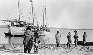
A century after the start of the thrilling expedition that strengthened claims to Canadian sovereignty in the Arctic, the first Canadian Arctic Expedition remains a largely unknown part of the country’s history