
Science & Tech
How Canada’s bridges impact energy
In a time where Canada is striving to close the gap between energy production and emissions, it seems fitting to explore how some of our country’s bridges improve urban…
- 485 words
- 2 minutes
This article is over 5 years old and may contain outdated information.
History
Today, fewer than 200 covered bridges survive in Canada.
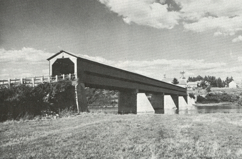
In 1805, American bridge builder Timothy Palmer put a roof on Philadelphia’s new Schuylkill Permanent Bridge, and North America’s first covered wooden bridge was born. For the next hundred years, covered bridges were built in the thousands in northeastern North America (mainly by small communities, farmers and businesses), with most of Canada’s more than 1,400 sprouting over rivers and streams in the forested farmland of Quebec and New Brunswick. And, as Montrealer Jacques Coulon explained in his August 1969 Canadian Geographical Journal cover story “Covered bridges in Canada,” roofs and siding weren’t just for looks and hiding young lovers (though they were also called “kissing bridges” for that reason): they sheltered bridge decks from sun and rain, raising life expectancy from 10 to 80 years, and much longer with maintenance.
But if a roof postponed decay, it couldn’t save the structures from being knocked down or bypassed in favour of modern highways and concrete bridges, targeted by arsonists or abandoned. By the summer of ’69, about 400 remained in Quebec and New Brunswick combined. “Always picturesque and just rare enough to arouse interest,” wrote Coulon, “covered wooden bridges seem growing in popular appeal at the very time they are dwindling in number.”
Today, fewer than 200 covered bridges survive in Canada. Yet Coulon would be happy to know that preservation societies did take action in Quebec and New Brunswick, and provincial governments instituted policies to help protect these century-old links — still there for travellers willing to explore the secondary roads.
Science & Tech
In a time where Canada is striving to close the gap between energy production and emissions, it seems fitting to explore how some of our country’s bridges improve urban…

History
When did aerial photography first emerge, and what’s happened in the years since?
Places
A look at how the Canadian Geographical Journal covered Vancouver’s 50th birthday

Mapping
Ontario has its fair share of waterways, and therefore has its fair share of bridges. This is how the provincial government keeps track of them all.