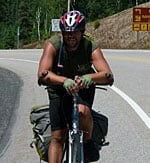
I recently had the opportunity to interview Michelle Swallow, author of the Mackenzie River Paddling Guide. A fortuitous meeting at the Yellowknife airport this past summer put Michelle in contact with paddling partners of mine, with whom I recently concluded a 50-day expedition to the Arctic Ocean via the Coppermine River.
When I came upon the guidebook in a Yellowknife bookstore, I was keen to find out more. Even just a cursory overview of the book’s contents gives one an indication that it is so much more than your standard river guide; the book is replete with historical, geographical and educational information that brings the Mackenzie’s past to life. The guidebook is a wonderful contribution to our knowledge of this region of the Canadian North.
Mackenzie River Paddling Guide Written by Michelle Swallow and Illustrated by Farah Denkovski
112 Pages Full Colour; 60 river maps
Published in July 2011
$34.95
[email protected]
www.mackenzieriverguide.ca
The Mackenzie River Paddling Guide on Facebook
River guides usually contain topographical maps and notes. Your book goes beyond that to include historical accounts and tales of the Mackenzie’s past. Why are those elements important?
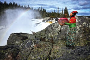
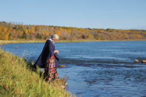
I wanted people, whether they paddle the river or not, to really get a feel for the Dehcho (Mackenzie River): The expanses of wilderness, the fur trading forts that are gone, the people that are still here and the stories that tie it all together. I love having detailed maps when I paddle but they don’t show you everything. Normally you flip to the history section or flip to the ecology section and then back to the map section, but real life isn’t like that. A historic fort, an important fishing area, a Dene legend – all of these things often occur at the same confluence, and I wanted people to see that as they paddled the river or read the guide.
Your illustrator, Farah Denkovski, accompanied you for much of the trip. But you also had other paddling companions at various legs of the trip. How did that shape your vision for the guide?
Farah was a wonderful trip partner. For the last section from Norman Wells to Tuktoyaktuk I also had my brother Bobby and his friend Sarafey join us. It was fantastic to experience the river both as a comforting memory in the places I was familiar with and through the eyes of Farah and Sarafey who had never been there.
Farah, my bro and Sarafey are also all incredibly creative which, in hindsight, was a pretty supportive and inspiring group of people to surround myself with.
Having other people on the trip also meant that we would meet more people. My brother would go for a walk and come across a community cookout and before long we were tasting moose nose and freshly caught fish. It was through those encounters that I would get a chance to talk to locals and learn more about the river sections that we were approaching and the stories behind the place names. This broadened my experiences and the information that I was able to include in the book.
The Mackenzie River is Canada’s largest river system, running an estimated length of 1850km — but remarkably, there are no portages along the way and you encounter minimal whitewater. What advice would you give a paddler embarking on a trip down the Mackenzie for the first time?
I think everyone paddling the Mackenzie River should be comfortable wilderness camping, have taken a paddling course or at least have canoe rescue techniques and the basic paddling strokes. I think you need to have common sense and the ability to be a safe and respectful camper — but you don’t need to be an expert paddler or an expedition leader. I think as long as you have sense to wait out bad weather the Dehcho is an extremely accessible river.
There are communities every few days so you don’t need to go crazy dehydrating food like on some trips; you can just pick up some eggs, bread and cheese at the store. Some communities have campgrounds where you can get a hot shower and a few even have restaurants and motels.
I suggest that everyone bring a Sat phone or a transceiver device like a SPOT, watch the weather, take your time, bring an attitude of gratitude and always stop for tea.
Besides paddlers, who else can learn from your guide book?
History follows the river, and provides a natural flow and context for the events that take place along it. Following a natural trail on the land or water is in my opinion a wonderful way to learn compared to memorizing dates along a ruler- straight, penciled timeline. I also strongly believe that we need children to know about the rivers if we ever expect them to care for them in the future.
I’ve heard through the grapevine that the guide is being used in the Northern Studies high school program, at least in Hay River, and I’ve received positive feedback from a few outdoor education programs that have taken the book along on their trips. As a future project, I would like to develop curriculum resources that could be used both in the classroom or in a canoe. There is such amazing history and beauty in the North there is no reason to exclude it from our learning.
Are there any parts of the book that you’re particular fond of, or sections that presented more difficulty than others?
I really enjoyed learning more about the stories of Yamoria. He is a cultural hero that is found in legends all across the Northwest Territories. Several of the legends are about places that you paddle by or are near the Mackenzie River – which is pretty amazing. It was also a bit of a challenge because Yamoria’s name changes as the stories pass through the different language groups down the river. As well, many of the books I was reading were English translations of French Journals so the names would all be different again, but I had a lot of fun trying to figure out who he was in the story, where the story took place and attempting to see how the stories piece together.
What other projects do you have on the horizon?
Water is so critical to the health of the North and to all of Canada, but many of our large waterways aren’t getting the distinction they deserve. There are books that talk about sections or pieces of the river but I haven’t seen a guide for the whole stretch. So I am aiming to create a guide for the Athabasca River that gives the river a little celebration. It will have a similar design to the Mackenzie River Guide but with an additional component of environmental education that like the other historical, cultural and ecological components will incorporate learning along the path of the river.