Mapping
10 fascinating historic maps of the Arctic
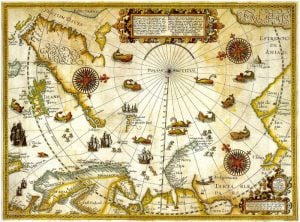
The mysteries of the Arctic have captivated explorers and mapmakers for centuries, as Europeans searched for northern sea routes to Asia.The blending of myth and fact in…
- 913 words
- 4 minutes
This article is over 5 years old and may contain outdated information.
Environment
Experts predict a busier than normal hurricane season for 2016

The Atlantic hurricane season officially begins June 1st, and experts say this could be a busier storm year than North Americans have come to expect.
The National Oceanic and Atmospheric Administration (NOAA) predicts up to 16 named storms of which four to eight could become hurricanes, and one to four could become major hurricanes. (According to the Saffir-Simpson hurricane wind scale, a storm gets a name when it has sustained winds of 68 to 118 km/h, becomes a hurricane when sustained winds reach 119 km/h, and is classified as a major hurricane when sustained winds surpass 178 km/h.)
If NOAA’s predictions come to pass, it will be a departure from the past couple of seasons, which have seen below-average activity in the Atlantic basin; 12 named storms were recorded during the 2015 season, while the 2014 season saw only nine. Of course, storm activity isn’t necessarily a predictor of storm intensity: the first named stormed of 2014, Arthur, made landfall in Nova Scotia at near Category 1 strength and dumped close to 150 mm of rain on parts of New Brunswick.
According to the Canadian Hurricane Centre, the number of storms reaching Canada each year has been on the increase since 2000, with about one hurricane making landfall every other year and one to two storms of tropical origin moving over land every year. As shown above in our map of hurricane activity over the past 148 years, a few storms have been truly devastating or noteworthy:
Mapping
The mysteries of the Arctic have captivated explorers and mapmakers for centuries, as Europeans searched for northern sea routes to Asia.The blending of myth and fact in…

Exploration
Ken Hedges of the 1968-69 British Trans Arctic Expedition reflects on the perilous and ground-breaking journey

Travel
The global explorer, adventurer, and TV host highlights his most dangerous experiences, regrets, what he has learned, and more
History
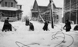
Climatologist David Phillips explores the meteorological legacy of the Great Lakes Storm of 1913